
-
-
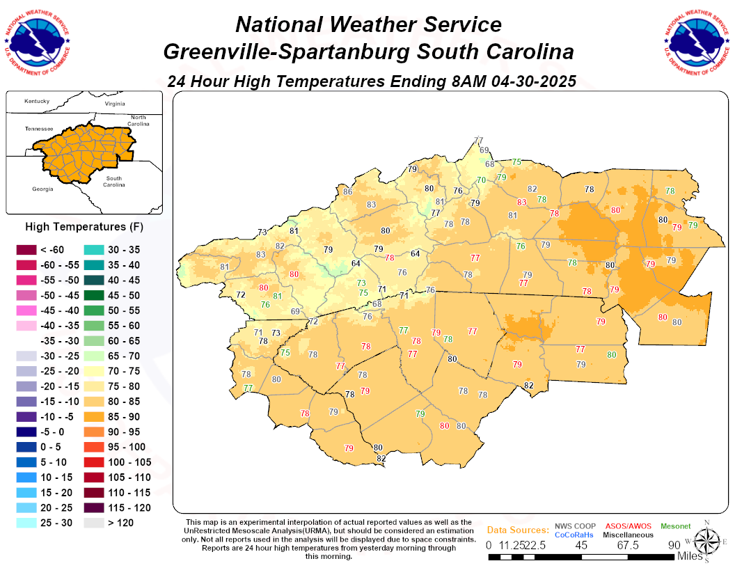
NC/SC High Temps Yesterday
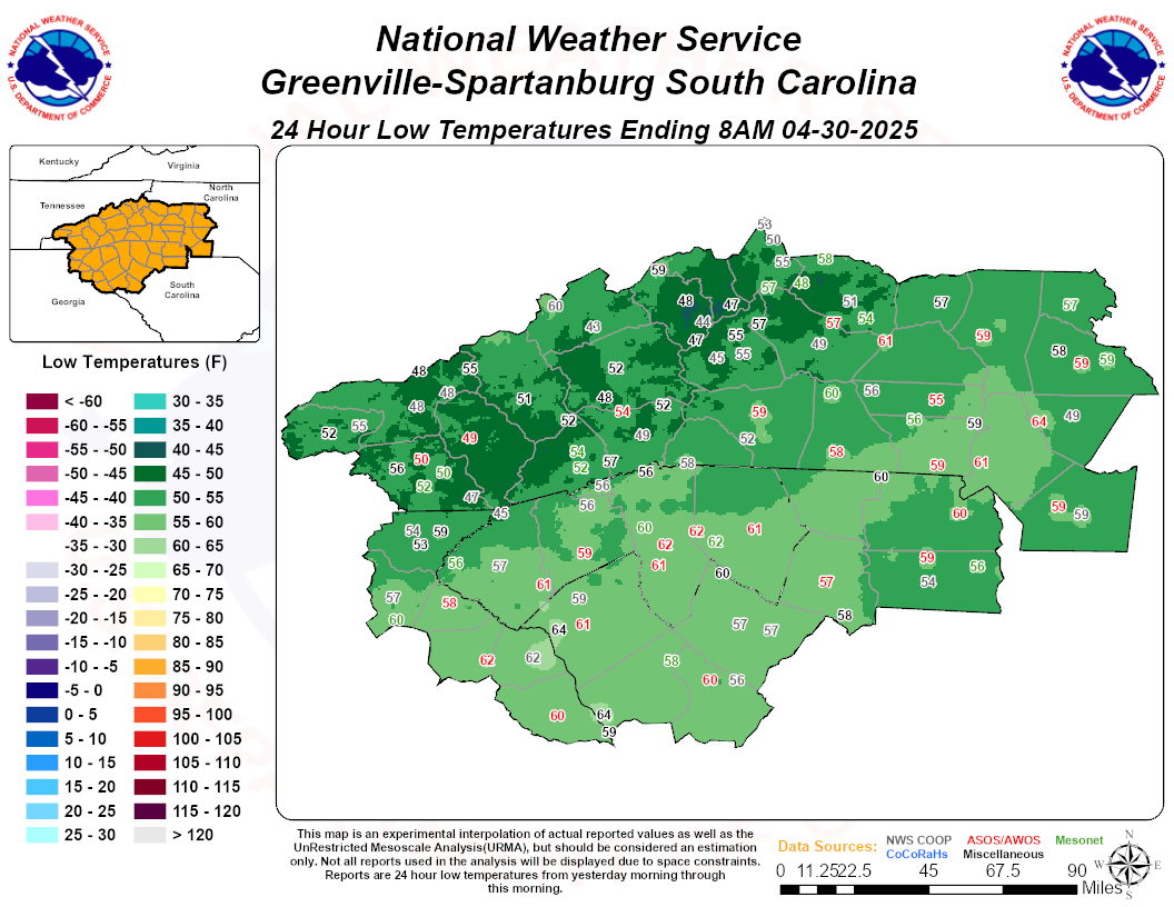
NC/SC Low Temps Yesterday
-
Blog Comments
-

-

By NorthGeorgiaWX · Posted
We went to the Great Loop Rendezvous, and here is the link to that. -
 At least living in Texas I am used to this unpleasantness.
 -
By NorthGeorgiaWX · Posted
Hey Ricky! We've headed over to Wheeler State Park in Alabama for a "Looper" Fall Rendezvous. It's a 3 day conference and there will be 25-30+ looper boats (some currently looping, others past loopers) there where you can tour and talk to the owners. I was waiting until then to "actively" start searching for a boat. I have a good idea what I'm looking for, but I'd really like to get on a few of these boats and talk with the owners about what they like, dislike, and what they would change abou -
 Steve Have you made any progress on your dream trip? It was so interesting reading of your childhood and your dad. I was not blessed to to be a part of such a lifestyle, though I wouldn’t trade the love I had at home with Dad and Mom and the spiritual background they installed in me. I have always had a mind that was full of imagination, loved to read. Louis La’mour was one of my favorite authors and I lived through his writings. I will look forward to your writings and descriptions to d
-
-
Posts
-
By NorthGeorgiaWX · Posted
SPC 1300Z Day 1 Outlook Day 1 Convective Outlook NWS Storm Prediction Center Norman OK 0749 AM CDT Fri Jul 26 2024 Valid 261300Z - 271200Z ...THERE IS A MARGINAL RISK OF SEVERE THUNDERSTORMS ACROSS THE NORTHERN PLAINS...GREAT BASIN...AND SOUTHWEST... ...SUMMARY... Isolated severe thunderstorms may occur today across the northern Plains, Great Basin, and parts of the Southwest. ...Northern Plains/Upper Midwest... A prominent upper-level trough will continue eastward today over the northern Canadian Prairies, with peripheral height falls and a strengthening of southwesterly winds aloft across the Dakotas and northern Minnesota. This will largely overlie an eastward-shifting front, that will be oriented northeast-southwestward across eastern North Dakota and roughly bisect South Dakota by late afternoon. Beneath a plume of very warm and capping elevated mixed-layer air, which will continue to advect northeastward across the northern Great Plains through the day, a seasonably moist boundary layer will support a narrow corridor of strong buoyancy across the Red River Valley vicinity by late afternoon, where forcing for ascent should support isolated to widely scattered thunderstorm development by early evening. In the presence of at least 30-40 kt deep-layer shear, a couple of supercells appear possible to the south of the international border, especially across northwest Minnesota, and perhaps as far southwest as areas near/west of Grand Forks and Fargo. Additional severe storms may also develop near/behind the front across western/central South Dakota and far eastern Wyoming into western Nebraska. ...Arizona... Cloud cover and outflows will abate across central/southern Arizona early today after a couple of relatively active thunderstorm days. This will be as the upper ridge over the Southwest further weakens and shifts southward. While thunderstorms are expected to develop/increase over the Rim this afternoon, and modestly stronger north-northeasterly steering flow may remain across far southeast Arizona, a less-active scenario seems likely as far as storms reaching the desert floor. While some strong/severe-caliber winds could occur, any such potential should remain relatively localized with a diminished overall severe risk from prior days. ...Great Basin... In the wake of a shortwave trough, storm coverage/intensity are not expected to be as active as Thursday, but moderate diurnal destabilization is expected especially across western/northern Utah, with isolated/widely scattered thunderstorm development expected this afternoon. A few of these storms could produce strong/severe-caliber downbursts. A secondary round, and perhaps somewhat greater coverage of storms, may occur tonight across Nevada into western/northern Utah, influenced by the eastward transition of the mid-level shortwave trough over northern California. ..Guyer/Grams.. 07/26/2024 Read more View the full article -
By NorthGeorgiaWX · Posted
No Mesoscale Discussions are in effect as of Fri Jul 26 08:46:01 UTC 2024.View the full article -
By NorthGeorgiaWX · Posted
Day 4-8 Outlook Day 4-8 Convective Outlook NWS Storm Prediction Center Norman OK 0340 AM CDT Fri Jul 26 2024 Valid 291200Z - 031200Z ...DISCUSSION... A low-amplitude upper-level ridge will be centered over the central CONUS on Monday and is forecast to slowly amplify through the week. As this occurs, northwest flow will strengthen from the northern Plains to the western Great Lakes and Midwest with high quality moisture in place. Severe weather may be possible during this period (most likely D5/Tue to D7/Thu). Most guidance shows convective precipitation signals and likely MCSs each afternoon, but based on the timing and amplitude of shortwave trough passages within the northwesterly flow, the uncertainty in location remains too high at this time to introduce probabilities. Farther east, an unusual progression of the upper-air pattern appears increasingly likely with a developing upper low over the Gulf Stream retrograding into New England on Monday and Tuesday. This general progression has been supported by the last several runs of the GFS and ECMWF and an even farther west shift occurred with the 00z ECMWF and EC ensemble which would bring an even larger warm sector onshore. This will need to monitored for the potential for at least some severe weather activity. Read more View the full article -
By NorthGeorgiaWX · Posted
SPC Day 2 Fire Weather Outlook Day 2 Fire Weather Outlook NWS Storm Prediction Center Norman OK 0158 AM CDT Fri Jul 26 2024 Valid 271200Z - 281200Z ...Synopsis... As a mid-level trough progresses eastward from California into the northern Great Basin on Saturday, isolated dry thunderstorms are expected across portions of eastern Idaho, southwestern Montana, western Wyoming, and portions of far northern Utah. This trough is also expected to bring dry and windy conditions to much of southern Nevada into southwestern Utah. ...Dry Thunder... An approaching trough from California is expected to bring chances for isolated dry thunderstorms to portions of Idaho, Montana, Wyoming, and Utah. Recent wetting rainfall could potentially limit some lightning ignitions, but pockets of receptive fuels still remain across much of the highlight area. Dry boundary-layer profiles will support gusty thunderstorm outflow that could contribute to wildfire spread with any lightning based ignitions. ...Southern Great Basin... Relative humidity of 5-10% and wind speeds of 25-30 MPH are expected across southern Nevada into southwestern Utah, exceeding the meteorological criteria for critical conditions. However, there is uncertainty in the receptiveness of fuels to wildfire spread due to recent significant wetting rainfall, precluding the inclusion of critical highlights at this time. ..Halbert/Weinman.. 07/26/2024 ...Please see www.spc.noaa.gov/fire for graphic product... Read more View the full article -
By NorthGeorgiaWX · Posted
No watches are valid as of Fri Jul 26 04:06:01 UTC 2024.View the full article
-

