Jump to content

2019 Tire Rack Lincoln Spring Nationals Champ Tour Weather - Sunday


NorthGeorgiaWX

656 views

Good Sunday morning to everyone!

Looks like Lincoln was brushed with some showers last night, but luckily the heavier stuff stayed to the south.

stp_lincoln-26.thumb.png.b01c810bea3b7848766f60772bdcb139.png


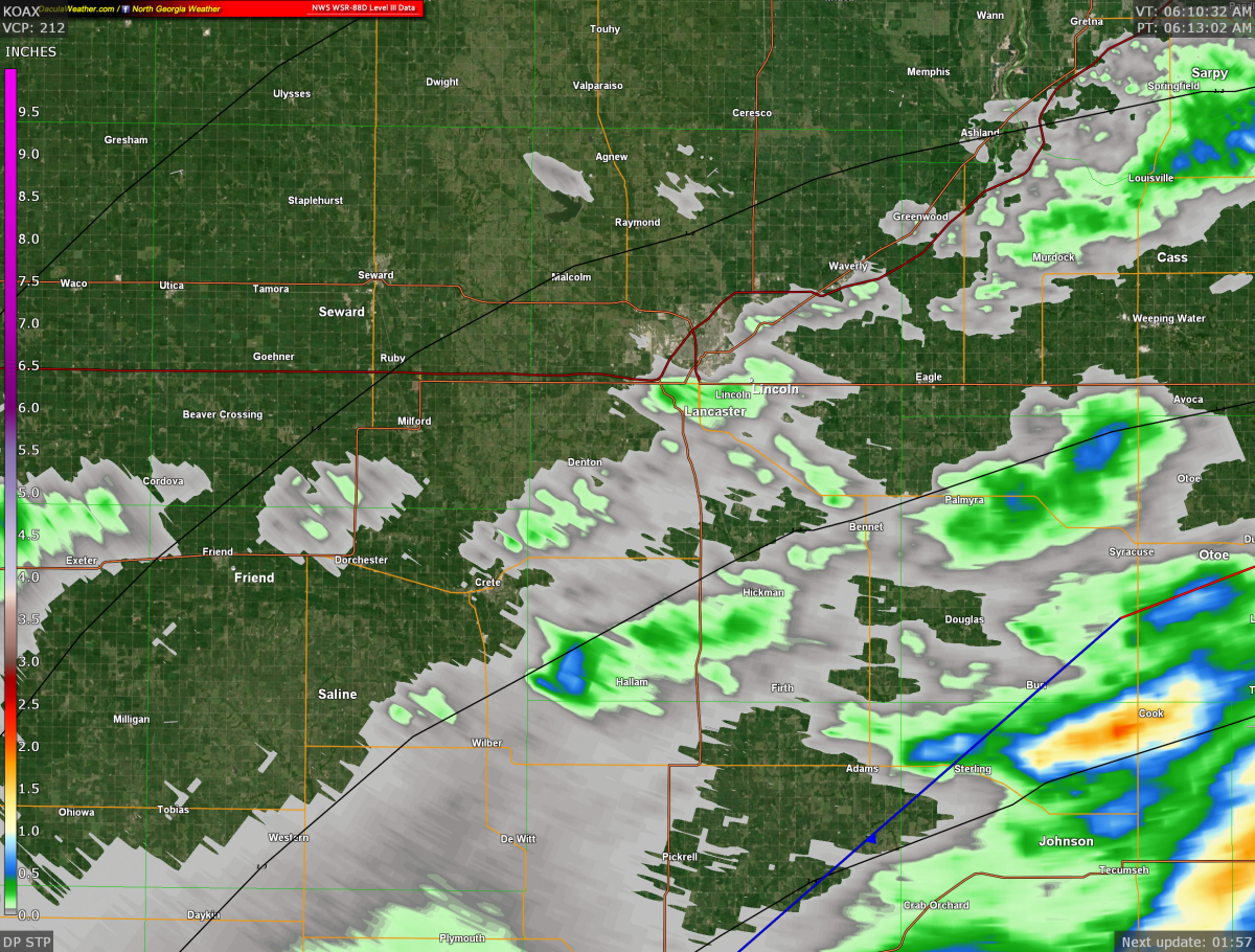
From the SPC Severe Weather Outlook maps, it appears the severe weather is dancing all around Lincoln, but it's afraid to get any closer, so it waits until Tuesday before making an appearance. 

1959176524_Tab3FileL(1).thumb.png.81f8e0a5153859270efb9a2066842cca.png


Quote

Lingering shower and thunderstorm activity will continue to
diminish through the early morning hours today. Generally dry
weather is expected today with high temperatures topping out in
the upper 70s. Precipitation chances will increase late this
evening and tonight as a shortwave surges out of the four corners
region. There is an enhanced risk for severe weather just off to
our west over south-central Nebraska, where supercells are
expected to develop this afternoon. Up to 30-40 kts of shear and
modest instability will be in place across the forecast area
Sunday evening to maintain a slight to marginal risk for severe
weather through the overnight hours. Damaging winds will be the
primary threat, as well as a chance for some large hail.

While this event appears to be fairly progressive, there is still
some concern about organized thunderstorm activity producing heavy
rainfall over areas with already saturated soil. Thankfully, the
bulk of the heaviest precip looks to set up further north, across
the middle of the CWA, which may be better set up to handle
additional rainfall. That being said, the need for another Flash
Flood Watch will have to be assessed as new model data arrives.

Remaining showers and thunderstorms will generally clear out of the
area Monday morning, giving the atmosphere an opportunity to reload.
A surface low will establish itself over eastern Colorado by Monday
afternoon, with a warm front extending from southwest Nebraska
through northern Iowa. Severe storms will be possible yet again
along this feature late Monday afternoon and evening.


All in all... not a bad day forecast. Most of the rain, if it rains, will fall in the evenings, leaving some nice dry concrete to go fast on! 

Have fun for me! 🙂

2 Comments


Recommended Comments

  • Administrators

Hope everything us secure on site. The bulk of the severe thunderstorms are about 80 miles away.

Lincoln in the upper right side of the image.

20190527_0107_kuex_BR_0.5.thumb.png.f0eb2cabe9dd5307388141bcdd6ab9e3.png


Link to comment
  • Administrators

There is a Severe Thunderstorm Watch to the west of Lincoln, but there is no indication at the moment that it will be extended east.

ww0257_radar.gif.395ce854ab663a1cc80da1941ad10d33.gif


Quote

URGENT - IMMEDIATE BROADCAST REQUESTED
   Severe Thunderstorm Watch Number 257
   NWS Storm Prediction Center Norman OK
   545 PM CDT Sun May 26 2019

   The NWS Storm Prediction Center has issued a

   * Severe Thunderstorm Watch for portions of 
     Central Kansas
     South-central Nebraska

   * Effective this Sunday afternoon from 545 PM until Midnight CDT.

   * Primary threats include...
     Scattered damaging wind gusts to 70 mph possible
     Isolated large hail events to 1.5 inches in diameter possible
     A tornado or two possible

   SUMMARY...Multiple clusters of strong to severe storms should spread
   east-northeast into central portions of Kansas and Nebraska this
   evening. Scattered severe wind gusts, isolated severe hail, and a
   brief tornado are the most likely hazards.

   The severe thunderstorm watch area is approximately along and 45
   statute miles east and west of a line from 30 miles east southeast
   of Dodge City KS to 20 miles west of Grand Island NE. For a complete
   depiction of the watch see the associated watch outline update
   (WOUS64 KWNS WOU7).

   PRECAUTIONARY/PREPAREDNESS ACTIONS...

   REMEMBER...A Severe Thunderstorm Watch means conditions are
   favorable for severe thunderstorms in and close to the watch area.
   Persons in these areas should be on the lookout for threatening
   weather conditions and listen for later statements and possible
   warnings. Severe thunderstorms can and occasionally do produce
   tornadoes.


Link to comment
Guest
Add a comment...

×   Pasted as rich text.   Paste as plain text instead

  Only 75 emoji are allowed.

×   Your link has been automatically embedded.   Display as a link instead

×   Your previous content has been restored.   Clear editor

×   You cannot paste images directly. Upload or insert images from URL.


×
×
  • Create New...