Weather on This Date - July 6
Today in Weather History
for July 6
July 6, 1893
A violent tornado killed 71 persons on its forty-mile track across northwestern Iowa. Forty-nine persons were killed around Pomeroy, where eighty percent of the buildings were destroyed, with most leveled to the ground. Photos showed most of the town without a wall or tree left standing. (The Weather Channel)
July 6, 1928
A hailstorm at Potter, NE, produced a stone which was 5.5 inches in diameter, and seventeen inches in circumference, weighing a pound and a half. (David Ludlum)
July 6, 1985
Lightning struck a large transformer in Salt Lake County sending a 200 foot fireball into the air and blacking out almost the entire state for up to five hours. (The Weather Channel)
July 6, 1986
Thunderstorm rains during the mid morning hours, and again during the evening, produced major flash-flooding at Leavenworth, KS. The official rainfall total was 10.37 inches, but unofficial totals exceeded twelve inches. At nearby Kansas City, the rainfall total of 5.08 inches was a daily record for July. (Storm Data)
July 6, 1987
Thunderstorms produced severe weather in twenty-one states east of the Rockies, with severe weather reported in Kentucky and Indiana for the second day in a row. A thunderstorm produced more than five inches of rain in one hour near Reynolds, IL. Rochester, NY, was soaked with 3.25 inches, a record 24 hour total for the month of July. (The National Weather Summary) (Storm Data)
July 6, 1988
Thirty-six cities in the north central and northeastern U.S. reported record high temperatures for the date. Afternoon highs of 98 degrees at International Falls, MN, and 101 degrees at Flint, MI, equalled all-time records. Highs of 96 degrees at Muskegon, MI, and 97 degrees at Buffalo, NY, were records for July. (The National Weather Summary)
July 6, 1989
Unseasonably hot weather prevailed in the southwestern U.S. Ten cities reported record high temperatures for the date, including Las Vegas, NV, with a reading of 115 degrees. Hanksville, UT, reached 112 degrees, Bullhead City, AZ, hit 120 degrees, and Death Valley, CA, soared to 126 degrees. (The National Weather Summary)
July 6, 2005
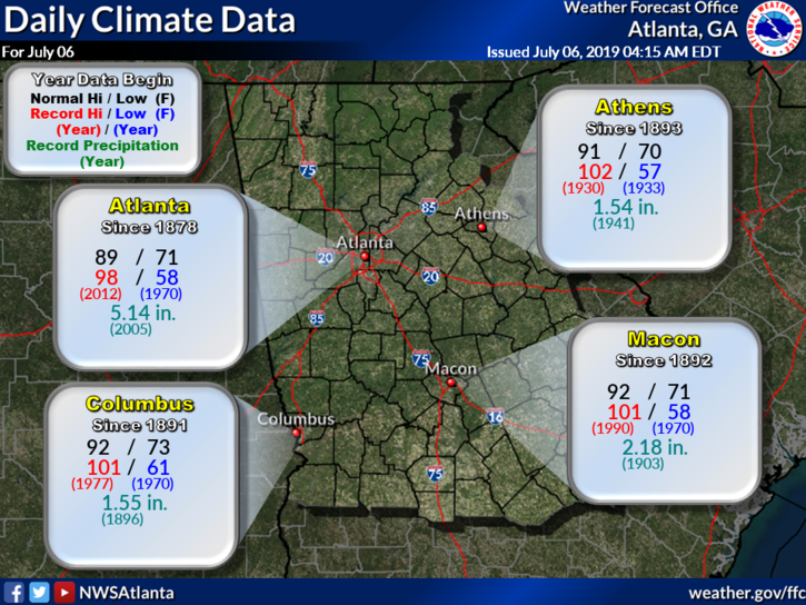
Tropical Storm Cindy moved across much of north and central Georgia producing widespread damage from winds gusting to 60 to 70 mph along with hail up to 1 inch. Several tornadoes were spawned by Cindy, the strongest being an F-2 which occurred in Hampton in Henry County. The tornado touched down at the Atlanta Motor Speedway and traveled north northwest to just east of Lovejoy in Clayton County. At the Atlanta Motor Speedway alone an estimated $40 million in damages were caused by the tornado. In its path, this tornado damaged 229 homes, with 61 homes sustaining major damage. In total, Tropical Storm Cindy caused over $75 million in damages across north and central Georgia. (NWS Atlanta)
Data courtesy of WeatherForYou


0 Comments
Recommended Comments
There are no comments to display.