

Thursday, August 29

Entry posted by NorthGeorgiaWX
750 views
Good morning fellow Solo people! 🙂 Sounds like aliens to me.
I know we have a lot of people onsite for tomorrow's ProSolo, so this section has to to with this afternoon and evening. There will be severe weather in the area, please make sure everything is secure, and the car is in a trailer if you have one.
QuoteToday`s primary weather concern will be a cold front moving south
through Iowa/Nebraska, and the potential for strong/severe storms
along the boundary later today. The overall thinking remains
similar to this time yesterday, with convection developing along
the front between 4 and 8 PM as convective temps are reached and
a weak midlevel shortwave tracks eastward out of the High Plains.
Model consensus places the boundary near the I-80 corridor during
this period, suggesting possible impacts in Omaha and Lincoln
around commute time.The atmosphere ahead or the boundary
continues to look favorable for severe convection (SBCAPE > 3,000
j/kg, mid level lapse rates around 7.5 C/km and DCAPE > 1,000
j/kg), though shear is marginal (0-6 km shear around 30 kt).
Isolated supercells are possible initially, before convection
grows upscale and pushes south under the influence of strong cold
pooling, continued frontal progression or both. The main hazards
should be hail and strong downburst winds. Isolated flash flooding
could also be a threat given PW values near 1.75 inches.
Accumulating precipitation looks like it will be limited to
locations along and south of I-80, with local 1 to 3 inch rain
totals possible. A few storms could linger into early Friday
morning. Confidence in the timing and location of potential
storms is moderate.

So please stay weather aware later this afternoon and evening. I will be around and making updates on the FB page if necessary.
Soooo, for tomorrow and Saturday.
QuoteAnother weak trough will track eastward out of the Rockies Friday
into Saturday. This, along with Thursdays frontal passage will bring
cooler and cloudier weather to the region to start the weekend.
Lift associated with the trough should also produce rain showers
(mainly Friday night and Saturday morning). Instability will be
lacking, so standard rain showers should be the prevailing weather
type as opposed to thunderstorms. Additional rainfall totals of a
quarter inch to an inch are possible. High temperatures Friday
and Saturday should be in the lower 70s. Confidence in the most
widespread precipitation being Friday night and Saturday morning
is moderate.
Looking at the NWS hour by hour forecast, Friday may be dry for most if not all of the competition.

Saturday isn't quite as good as much of the morning has damp conditions with light scattered showers around. At least we not seeing the deluge type rain that we saw last year.

Looking ahead, Tuesday and Wednesday look good for now! There is a cold front coming through that will drop the temperatures back down on Wednesday, but when or if any rain accompanies the front is this to be seen.
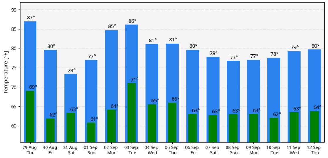
Temps may look like this.
But I know temps aren't what's really important, it's the rain.
The GFS ensembles show about 0.30" of rain during the frontal passage next week, while the Euro comes in a little less at around 0.10". So for now, let's split the difference. The exact timing of that front is of course unknown right now, but we can pretend it's overnight Wednesday into Thursday for now. Don't worry. It will change.


So that's it for now, I hope everyone got there safe and I hope the severe weather stays away from Lincoln tonight. If not, I'll be keeping you updated!
Have a great day!
0 Comments
Recommended Comments
There are no comments to display.