
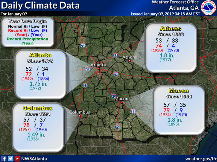
Weather on This Date - January 9

Entry posted by NorthGeorgiaWX
764 views

January 9, 1875
The temperature at Cheyenne, WY, dipped to an all-time record cold reading of -38 degrees. (The Weather Channel)
January 9, 1888
Severe cold gripped much of the western U.S. At Portland OR the Columbia River was frozen for two weeks, and in southern California temperatures dipped below freezing in some of the citrus growing areas. (David Ludlum)
January 9, 1976
Lake effect snow squalls buried the town of Adams NY under 68 inches of snow. (David Ludlum)
January 9, 1987
A winter storm spread heavy snow from the Central Plains into the Great Lakes Region. Heavier totals included 9 inches at Sun City KS, 7 inches at Columbia MO, 11 inches at Terre Haute IN, and up to 10 inches in the southern suburbs of Chicago IL. (National Weather Summary) ( Storm Data)
January 9, 1988
A storm in the northeastern U.S. produced ten inches of snow at Boston MA, and 14 inches at Worcester MA. A winter storm in the northwestern U.S. produced a foot of snow in three hours at McCall ID. (National Weather Summary) (Storm Data)
January 9, 1989
Strong winds prevailed along the eastern slopes of the Rockies in Colorado. Winds gusted to 113 mph at the Air Force Academy near Colorado Springs, and reached 115 mph at Boulder. (National Weather Summary) (Storm Data)
January 9, 1990
A third storm in four days hit the Pacific Northwest. Winds in Oregon gusted above 100 mph at Netarts and at Oceanside. Up to 8.16 inches of rain was reported around Seaside OR, and the total of 4.53 inches of rain at Astoria OR was a record for the date. Twelve cities in the western U.S. reported record high temperatures for the date. The high of 70 degrees at Cedar City UT was a record for January. (National Weather Summary) (Storm Data)
January 9, 2001
An area of light snow moved across Dade, Fannin, Gilmer, Murray, Pickens, and Union Counties. Most locations only saw a light dusting of snow, but Gilmer County reported 1 inch of snow. Road problems were limited to icy or slick spots mainly on bridges and overpasses. (NWS Atlanta)
January 9, 2011
An upper level disturbance tracked across the northern Gulf of Mexico, drawing abundant moisture into the Southeastern U.S. Prior to the arrival of the moisture, a large, cool area of high pressure was entrenched over the southern United States, and this helped set the stage for one of the more significant winter weather events in years. 2" to a foot of snow fell from just south of the metro Atlanta area to the TN border. Areas south of the snow saw ice up to 3/4" thick. Atlanta schools were closed for 5 straight days.
For the event summary, click this link
Data courtesy of WeatherForYou
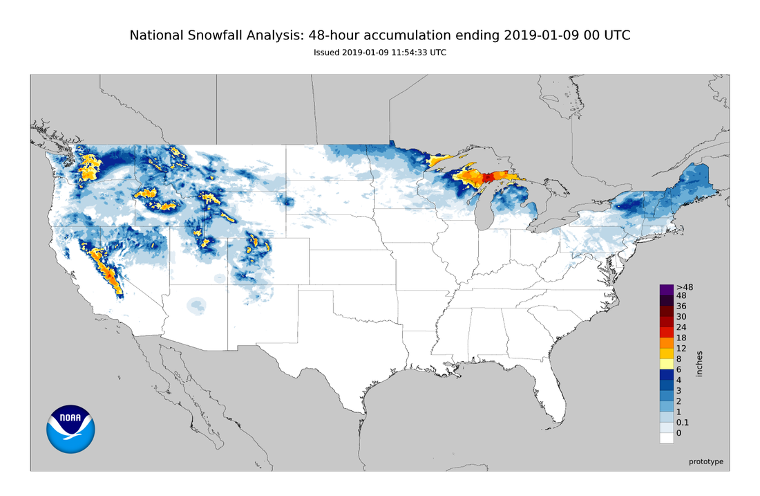
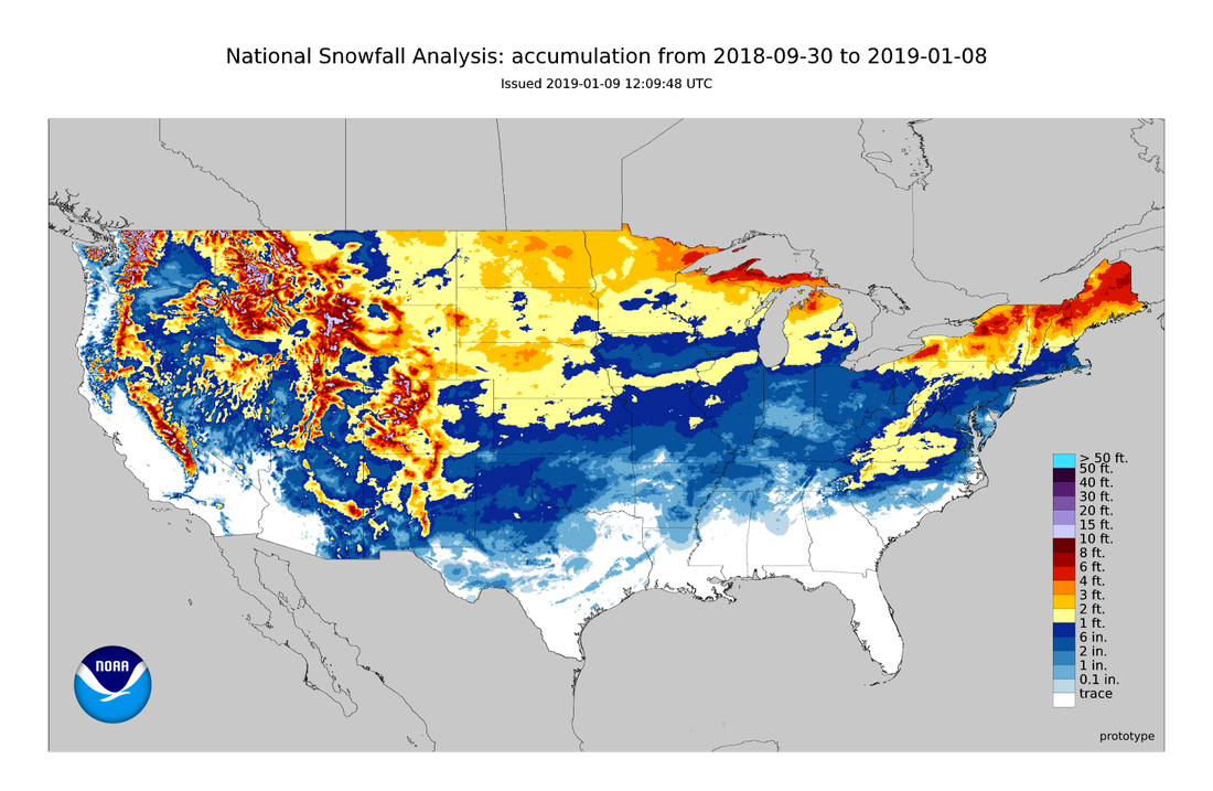
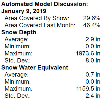
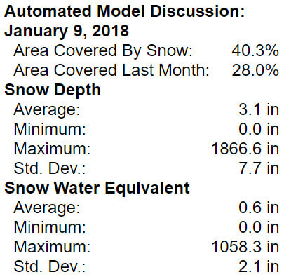
Snow Cover Analysis
|
|
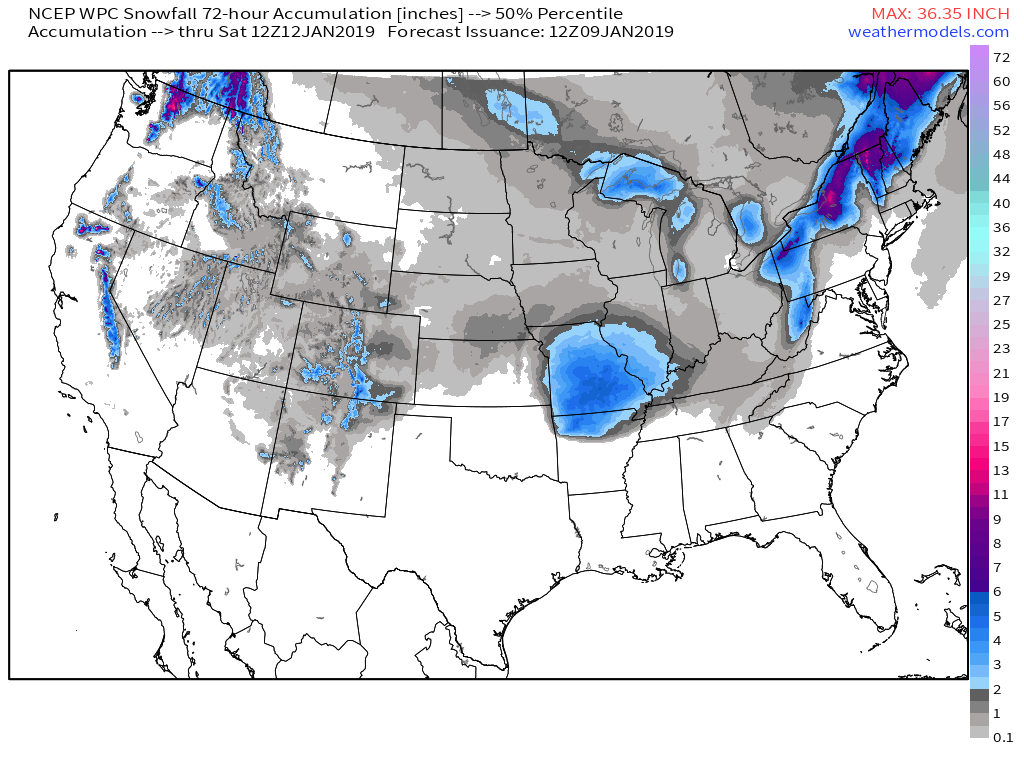
WPC 72 Hour Snow Forecast
0 Comments
Recommended Comments
There are no comments to display.