
-
National Weather Service - Morristown TN
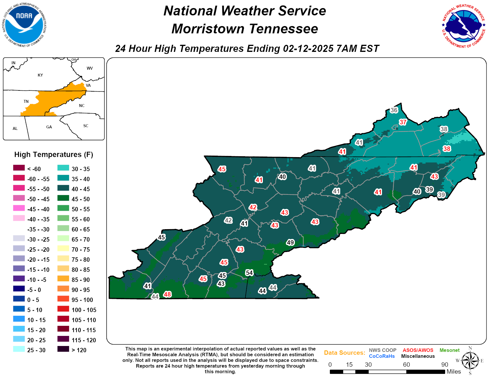
East TN High Temps Yesterday
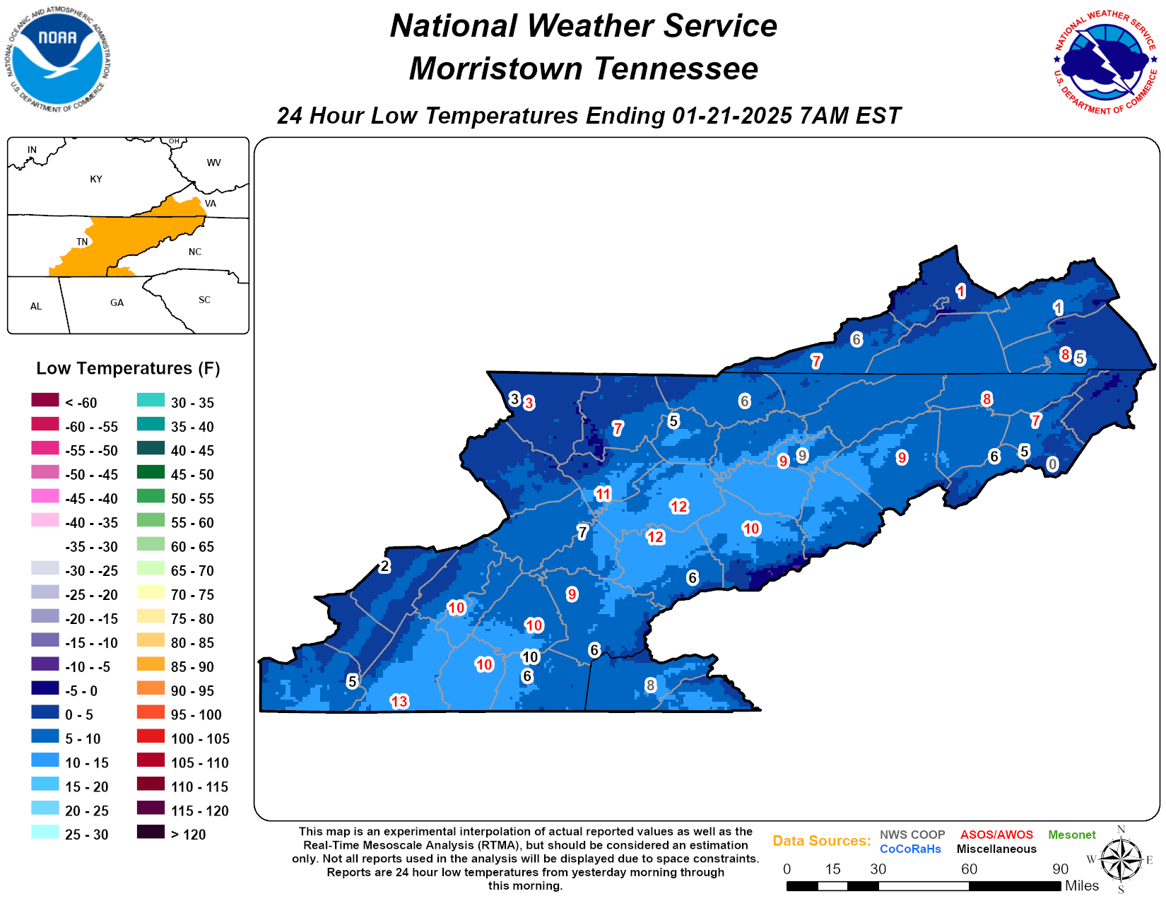
East TN Low Temps Yesterday
-
Posts
-

By Guest BryanAvaby · Posted
Hello! Do you want to become the best SEO specialist and link builder or do you want to outpace your competitors? Premium base for XRumer $119/one-time Get access to our premium database, which is updated monthly! The database contains only those resources from which you will receive active links - from profiles and postings, as well as a huge collection of contact forms. Free database updates. There is also the possibility of a one-time purchase, without updating the databases, for $38. Fresh base for XRumer $94/one-time Get access to our fresh database, updated monthly! The database includes active links from forums, guest books, blogs, etc., as well as profiles and activations. Free database updates. There is also the possibility of a one-time purchase, without updating the databases, for $25. GSA Search Engine Ranker fresh verified link list $119/one-time Get access to our fresh database, updated monthly! The fresh database includes verified and identified links, divided by engine. Free database updates. There is also the possibility of a one-time purchase, without updating the databases, for $38. GSA Search Engine Ranker activation key $65 With GSA Search Engine Ranker, you'll never have to worry about backlinks again. The software creates backlinks for you 24 hours a day, 7 days a week. By purchasing GSA Search Engine Ranker from us, you get a quality product at a competitive price, saving your resources. To contact us write to Telegram: https://t.me/DropDeadStudio -

By NorthGeorgiaWX · Posted
SPC 1930Z Day 3 Outlook Day 3 Convective Outlook NWS Storm Prediction Center Norman OK 0213 PM CDT Mon Oct 21 2024 Valid 231200Z - 241200Z ...NO SEVERE THUNDERSTORM AREAS FORECAST... ...SUMMARY... No severe thunderstorms are expected on Wednesday. ...Synopsis... A strong shortwave trough is forecast to extend from southern Hudson Bay through the Upper Great Lakes and Upper Midwest early Wednesday morning. This shortwave is expected to make steady eastward progress throughout the day, traversing across Ontario and Quebec as well as the Great Lakes and Northeast states. A cold front will accompany this system, moving just ahead of the upper trough. Current expectation is that this front will progress across the Northeast from 21Z through 03Z. Low-level moisture preceding this front across the Northeast will be modest (i.e. upper 40s/low 50s dewpoints), limiting buoyancy and likely keeping most of the convection along and ahead of the front shallow. A few deeper cores could result in isolated lightning flashes. Additionally, robust low to mid-level westerly flow could result in a few stronger, convectively augmented gusts within the deeper cores in the strongly forced convective line. Currently, minimal buoyancy and shallow nature to the convection along and ahead of the front is expected to limit the coverage of any damaging gusts. However, if greater instability and more robust convection can develop, some damaging wind gusts could be possible with this strongly forced convection. Trends within the guidance will be monitored closely to determine if low severe probabilities will be needed in later outlooks. ..Mosier.. 10/21/2024 Read more View the full article -
By NorthGeorgiaWX · Posted
MD 2155 CONCERNING SEVERE POTENTIAL...WATCH POSSIBLE FOR PARTS OF WESTERN INTO CENTRAL KANSAS AND ADJACENT SOUTHERN NEBRASKA Mesoscale Discussion 2155 NWS Storm Prediction Center Norman OK 0159 PM CDT Mon Oct 21 2024 Areas affected...parts of western into central Kansas and adjacent southern Nebraska Concerning...Severe potential...Watch possible Valid 211859Z - 212100Z Probability of Watch Issuance...40 percent SUMMARY...Widely scattered strong to severe thunderstorm development appears increasingly possible by 3-5 PM CDT. The stronger storms will probably pose the risk for severe hail, but a brief tornado or two may also be possible. It is not certain this will require a severe weather watch, but trends are being monitored for this possibility. DISCUSSION...The southwestern flank of relatively cool boundary-layer air stabilized by convective precipitation is gradually eroding, roughly from the McCook and Hill City vicinities south-southeastward toward Medicine Lodge. Along and to the immediate west, a narrow corridor of modest boundary-layer moisture (characterized by mid/upper 50s F surface dew points) is being maintained long enough to contribute to CAPE on the order of 500 to 1000 J/kg, as the leading edge of the compact mid-level cold core continues to shift across/east of the central high plains. Attempts at deepening convective development are ongoing within this corridor of destabilization, most notably to the west-southwest and southwest of Hill City. It appears the corridor of stronger destabilization will continue to develop slowly northeastward and eastward through the remainder of the afternoon. As this occurs, it probably will become increasingly supportive of thunderstorm initiation through the 20-22Z time frame. In the presence of favorable low-level and deep-layer shear, beneath 40 kt southerly 850 mb flow veering to 50-60 kt southwesterly at 500 mb, the environment appears conducive to the development of a couple of supercells. Large hail appears the primary potential severe hazard, but low-level hodographs might be conducive to a brief tornado or two. ..Kerr/Guyer.. 10/21/2024 ...Please see www.spc.noaa.gov for graphic product... ATTN...WFO...ICT...GID...DDC...GLD... LAT...LON 40270079 39959901 38909877 38119830 37299863 37139954 37909997 38460022 39200110 40270079 Read more View the full article -
By NorthGeorgiaWX · Posted
SPC 1730Z Day 2 Outlook Day 2 Convective Outlook NWS Storm Prediction Center Norman OK 1219 PM CDT Mon Oct 21 2024 Valid 221200Z - 231200Z ...NO SEVERE THUNDERSTORM AREAS FORECAST... ...SUMMARY... No severe thunderstorms are forecast on Tuesday. ...Synopsis... A shortwave trough is forecast to be over western IA early Tuesday morning before continuing northeastward throughout the day across the Mid/Upper MS Valley and Upper Great Lakes and becoming absorbed in the stronger westerlies. Isolated to widely scattered elevated thunderstorms are possible Tuesday morning ahead of this wave across the Mid MS Valley. Buoyancy will be modest, which should temper updraft strength in most of these storms. However, relatively cool mid-level temperatures and enhanced mid-level flow could result in enough buoyancy and shear for a few instances of small hail. Another shortwave trough is expected to progress through the Canadian Prairies on Tuesday. This shortwave is expected to amplify considerably as it moves into far northwestern Ontario. By 12Z Wednesday, this shortwave is expected to extend from the Hudson Bay through western Ontario and the Upper Midwest. A surface low will precede this system, with an attendant cold front pushing southeastward across the Upper Midwest and Upper Great Lakes. Low-level moisture in the vicinity of this front will be minimal, but increasing mid-level moisture coupled with cold mid-level temperatures could still promote enough buoyancy for a few deeper updrafts capable of producing lightning from northern MN into far northern WI and western upper MI. Lastly, a thunderstorm or two appears possible across southern portions of far west TX/TX Big Bend vicinity Tuesday afternoon. Here, some airmass destabilization appears possible amid strong heating, and there could be just enough low-level convergence for convective initiation. Overall coverage in this area is currently expected to be less than 10%. ..Mosier.. 10/21/2024 Read more View the full article
-
-
Blog Entries
-

