


NorthGeorgiaWX
-
Posts
34,607 -
Joined
-
Last visited
-
Days Won
1,501
Content Type
Profiles
Blogs
Forums
Gallery
Events
Store
Downloads
Posts posted by NorthGeorgiaWX
-
-
WW 0266 Status Updates

STATUS REPORT ON WW 266

SEVERE WEATHER THREAT CONTINUES RIGHT OF A LINE FROM 25 SSW CQB
TO 25 NNE CQB TO 15 SSW TUL TO 25 E TUL TO 10 E GMJ.

..GOSS..05/20/24

ATTN...WFO...TSA...OUN...


STATUS REPORT FOR WS 266

SEVERE WEATHER THREAT CONTINUES FOR THE FOLLOWING AREAS

OKC001-021-035-037-041-081-083-091-097-101-107-111-115-119-131-
143-145-201040-

OK
.    OKLAHOMA COUNTIES INCLUDED ARE

ADAIR                CHEROKEE            CRAIG
CREEK                DELAWARE            LINCOLN
LOGAN                MCINTOSH            MAYES
MUSKOGEE             OKFUSKEE            OKMULGEE
OTTAWA               PAYNE               ROGERS
TULSA                WAGONER


THE WATCH STATUS MESSAGE IS FOR GUIDANCE PURPOSES ONLY.  PLEASE
REFER TO WATCH COUNTY NOTIFICATION STATEMENTS FOR OFFICIAL
INFORMATION ON COUNTIES...INDEPENDENT CITIES AND MARINE ZONES
CLEARED FROM SEVERE THUNDERSTORM AND TORNADO WATCHES.
Read more -
WW 0266 Status Updates
STATUS REPORT ON WW 266

SEVERE WEATHER THREAT CONTINUES RIGHT OF A LINE FROM 25 SSW CQB
TO 25 NNE CQB TO 15 SSW TUL TO 25 E TUL TO 10 E GMJ.

..GOSS..05/20/24

ATTN...WFO...TSA...OUN...


STATUS REPORT FOR WS 266

SEVERE WEATHER THREAT CONTINUES FOR THE FOLLOWING AREAS

OKC001-021-035-037-041-081-083-091-097-101-107-111-115-119-131-
143-145-201040-

OK
.    OKLAHOMA COUNTIES INCLUDED ARE

ADAIR                CHEROKEE            CRAIG
CREEK                DELAWARE            LINCOLN
LOGAN                MCINTOSH            MAYES
MUSKOGEE             OKFUSKEE            OKMULGEE
OTTAWA               PAYNE               ROGERS
TULSA                WAGONER


THE WATCH STATUS MESSAGE IS FOR GUIDANCE PURPOSES ONLY.  PLEASE
REFER TO WATCH COUNTY NOTIFICATION STATEMENTS FOR OFFICIAL
INFORMATION ON COUNTIES...INDEPENDENT CITIES AND MARINE ZONES
CLEARED FROM SEVERE THUNDERSTORM AND TORNADO WATCHES.
Read more -
WW 266 SEVERE TSTM OK 200440Z - 201100Z
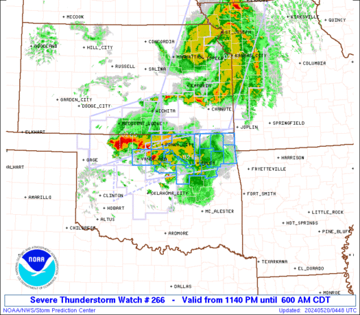
URGENT - IMMEDIATE BROADCAST REQUESTED
Severe Thunderstorm Watch Number 266
NWS Storm Prediction Center Norman OK
1140 PM CDT Sun May 19 2024

The NWS Storm Prediction Center has issued a

* Severe Thunderstorm Watch for portions of
  Northern into Northeast Oklahoma

* Effective this Sunday night and Monday morning from 1140 PM
  until 600 AM CDT.

* Primary threats include...
  Scattered large hail and isolated very large hail events to 2
    inches in diameter possible
  Scattered damaging wind gusts to 70 mph possible

SUMMARY...Scattered strong to severe thunderstorms will likely
persist tonight and gradually develop east across the Watch area.  A
west to east oriented cluster of thunderstorms, occasionally
containing a supercell or two, will potentially be capable of large
hail and severe gusts.

The severe thunderstorm watch area is approximately along and 35
statute miles north and south of a line from 45 miles southwest of
Ponca City OK to 5 miles east of Grove OK. For a complete depiction
of the watch see the associated watch outline update (WOUS64 KWNS
WOU6).

PRECAUTIONARY/PREPAREDNESS ACTIONS...

REMEMBER...A Severe Thunderstorm Watch means conditions are
favorable for severe thunderstorms in and close to the watch area.
Persons in these areas should be on the lookout for threatening
weather conditions and listen for later statements and possible
warnings. Severe thunderstorms can and occasionally do produce
tornadoes.

&&

OTHER WATCH INFORMATION...CONTINUE...WW 262...WW 264...WW 265...

AVIATION...A few severe thunderstorms with hail surface and aloft to
2 inches. Extreme turbulence and surface wind gusts to 60 knots. A
few cumulonimbi with maximum tops to 500. Mean storm motion vector
27025.

...Smith
Read more -
WW 266 SEVERE TSTM OK 200440Z - 201100Z
URGENT - IMMEDIATE BROADCAST REQUESTED
Severe Thunderstorm Watch Number 266
NWS Storm Prediction Center Norman OK
1140 PM CDT Sun May 19 2024

The NWS Storm Prediction Center has issued a

* Severe Thunderstorm Watch for portions of
  Northern into Northeast Oklahoma

* Effective this Sunday night and Monday morning from 1140 PM
  until 600 AM CDT.

* Primary threats include...
  Scattered large hail and isolated very large hail events to 2
    inches in diameter possible
  Scattered damaging wind gusts to 70 mph possible

SUMMARY...Scattered strong to severe thunderstorms will likely
persist tonight and gradually develop east across the Watch area.  A
west to east oriented cluster of thunderstorms, occasionally
containing a supercell or two, will potentially be capable of large
hail and severe gusts.

The severe thunderstorm watch area is approximately along and 35
statute miles north and south of a line from 45 miles southwest of
Ponca City OK to 5 miles east of Grove OK. For a complete depiction
of the watch see the associated watch outline update (WOUS64 KWNS
WOU6).

PRECAUTIONARY/PREPAREDNESS ACTIONS...

REMEMBER...A Severe Thunderstorm Watch means conditions are
favorable for severe thunderstorms in and close to the watch area.
Persons in these areas should be on the lookout for threatening
weather conditions and listen for later statements and possible
warnings. Severe thunderstorms can and occasionally do produce
tornadoes.

&&

OTHER WATCH INFORMATION...CONTINUE...WW 262...WW 264...WW 265...

AVIATION...A few severe thunderstorms with hail surface and aloft to
2 inches. Extreme turbulence and surface wind gusts to 60 knots. A
few cumulonimbi with maximum tops to 500. Mean storm motion vector
27025.

...Smith
Read more -
SPC Day 2 Fire Weather Outlook
Day 2 Fire Weather Outlook
NWS Storm Prediction Center Norman OK
0202 AM CDT Mon May 20 2024

Valid 211200Z - 221200Z

...Synopsis...
Moderate mid-level flow will remain across the Southwest on Tuesday
with single-digit relative humidity across New Mexico. As deep
mixing develops during the afternoon, some of this stronger flow
will mix to the surface. In addition, a secondary lee cyclone is
expected to develop in the TX/OK Panhandle vicinity. This will also
aid in stronger surface winds. 15 to 25 mph sustained surface winds
are expected across much of New Mexico. Locally critical conditions
are probable and a Critical delineation may be needed at a later
time, but for now, it is unclear where within the broader Elevated
area, the greater threat may be.

..Bentley.. 05/20/2024

...Please see www.spc.noaa.gov/fire for graphic product...
Read more -
SPC Day 1 Fire Weather Outlook
Day 1 Fire Weather Outlook
NWS Storm Prediction Center Norman OK
0202 AM CDT Mon May 20 2024

Valid 201200Z - 211200Z

...Synopsis...
A mid-level jet streak will overspread the Southwest this afternoon
as a mid-level trough amplifies across the western CONUS. A deeply
mixed boundary layer is expected across Arizona and New Mexico with
temperatures in the 90s. Some of this stronger flow will mix to the
surface amid the deep boundary layer. In addition, lee cyclogenesis
will tighten the pressure gradient in the region and aid in stronger
surface winds. Sustained surface winds of 25 to 30 mph are expected
across New Mexico with some sustained winds over 30 mph in northern
Arizona. Single-digit relative humidity is also expected across most
of the region. Fuels have started to dry to critical levels across
portions of eastern and northern Arizona. Therefore, a Critical
delineation is warranted.

..Bentley.. 05/20/2024

...Please see www.spc.noaa.gov/fire for graphic product...
Read more -
WW 0265 Status Updates
STATUS REPORT ON WW 265

SEVERE WEATHER THREAT CONTINUES RIGHT OF A LINE FROM 45 SSW AVK
TO 30 WNW AVK TO 20 E ICT.

..GOSS..05/20/24

ATTN...WFO...DDC...ICT...OUN...


STATUS REPORT FOR WS 265

SEVERE WEATHER THREAT CONTINUES FOR THE FOLLOWING AREAS

KSC015-077-191-200640-

KS
.    KANSAS COUNTIES INCLUDED ARE

BUTLER               HARPER              SUMNER


OKC003-053-093-151-200640-

OK
.    OKLAHOMA COUNTIES INCLUDED ARE

ALFALFA              GRANT               MAJOR
WOODS


THE WATCH STATUS MESSAGE IS FOR GUIDANCE PURPOSES ONLY.  PLEASE
REFER TO WATCH COUNTY NOTIFICATION STATEMENTS FOR OFFICIAL
INFORMATION ON COUNTIES...INDEPENDENT CITIES AND MARINE ZONES
CLEARED FROM SEVERE THUNDERSTORM AND TORNADO WATCHES.
Read more -
WW 0262 Status Updates
STATUS REPORT ON WW 262

SEVERE WEATHER THREAT CONTINUES RIGHT OF A LINE FROM 10 NE ICT TO
25 SSW EMP TO 50 SSE OJC TO CDJ TO 35 WNW LWD.

..GOSS..05/20/24

ATTN...WFO...DMX...OAX...ICT...TOP...EAX...SGF...


STATUS REPORT FOR WS 262

SEVERE WEATHER THREAT CONTINUES FOR THE FOLLOWING AREAS

IAC001-003-029-039-053-117-121-159-173-175-181-185-200640-

IA
.    IOWA COUNTIES INCLUDED ARE

ADAIR                ADAMS               CASS
CLARKE               DECATUR             LUCAS
MADISON              RINGGOLD            TAYLOR
UNION                WARREN              WAYNE


KSC001-011-019-021-035-037-049-073-099-107-125-133-205-207-
200640-

KS
.    KANSAS COUNTIES INCLUDED ARE

ALLEN                BOURBON             CHAUTAUQUA
CHEROKEE             COWLEY              CRAWFORD
ELK                  GREENWOOD           LABETTE
LINN                 MONTGOMERY          NEOSHO
WILSON               WOODSON


MOC011-013-033-079-081-083-101-117-129-217-227-200640-
Read more -
Flood Warning issued May 19 at 9:19PM EDT by NWS Jacksonville FL
-
Flood Warning issued May 19 at 9:06PM EDT until May 24 at 11:00PM EDT by NWS Charleston SC
-
Flood Warning issued May 19 at 9:03PM EDT until May 22 at 8:00AM EDT by NWS Tallahassee FL
-
Flood Warning issued May 19 at 9:02PM EDT by NWS Tallahassee FL
-
Flood Warning issued May 19 at 9:01PM EDT until May 23 at 6:30PM EDT by NWS Tallahassee FL
-
SPC Day 2 Fire Weather Outlook
Day 2 Fire Weather Outlook
NWS Storm Prediction Center Norman OK
0137 PM CDT Thu May 16 2024

Valid 171200Z - 181200Z

...NO CRITICAL AREAS...

...2000Z Update...
A surface low will deepen in the lee of the northern Rockies over
the High Plains of southeast Montana and northeast Wyoming Friday in
association with an approaching mid-level trough. The resulting
pressure gradient will support breezy westerly sustained surface
winds around 20 to 30 mph from central Montana into Idaho and
southwest Wyoming. There's still some disagreement on how low RH
will drop across northeast Idaho and far western/southwestern
Wyoming, as mentioned in the previous forecast. Regardless, recent
rainfall over this region and relatively low fuel receptiveness will
limit the overall fire spread threat.

..Barnes/Nauslar.. 05/16/2024

.PREV DISCUSSION... /ISSUED 0122 AM CDT Thu May 16 2024/

...Synopsis...
A pronounced mid-level trough will eject into the northern Plains
today, supporting strong surface lee troughing over the northern
High Plains tomorrow (Friday). A widespread, strong surface wind
field will develop over Wyoming and points eastward as a result.
However, guidance varies considerably in terms of how low RH will
drop by afternoon peak heating, with some guidance members showing
RH dropping as low as 15 percent in some spots, while other members
show RH staying well above 25 percent in many locales. When also
considering recent rainfall that portions of the northern Plains has
received in the past week, fuel receptiveness to wildfire spread
should also be mediocre. Fire weather highlights have been withheld
given the aforementioned uncertainties with RH and fuels.
Nonetheless, localized instances of wildfire growth cannot be ruled
out where dry fuel beds exist given the strong winds.

...Please see www.spc.noaa.gov/fire for graphic product...
Read more -
MD 0802 CONCERNING SEVERE POTENTIAL...WATCH LIKELY FOR SOUTHEAST TEXAS INTO SOUTHWEST LOUISIANA
Mesoscale Discussion 0802
NWS Storm Prediction Center Norman OK
0112 PM CDT Thu May 16 2024

Areas affected...southeast Texas into southwest Louisiana

Concerning...Severe potential...Watch likely

Valid 161812Z - 162045Z

Probability of Watch Issuance...80 percent

SUMMARY...Storms are likely to develop after 19Z from southeast
Texas into southwest Louisiana. Large hail as well as damaging gusts
will be likely, and a brief tornado will be possible as well.

DISCUSSION...A line of storms stretching from central into northeast
TX continues to shift east/southeast, with prominent outflow.
Although the air mass ahead of this line continues to gradually
destabilize due to heating, a surge of rich boundary layer moisture
is moving in from the southwest, and this will provide a greater
contribution. GPS PWAT values will increase rapidly by over 0.50" as
the mid to upper 70s F dewpoints arrive. Indicative of this robust
moisture are cells forming within the warm advection zone just off
the LA Coast.

Therefore, as the primary line of storms moves in from the
northwest, strengthening may occur especially where the line
intersects the warm front, with additional cells forming along the
length of the warm front. Damaging hail and wind will be likely.
Low-level shear along the warm front may support a brief tornado or
two as well, with 0-1 SRH values above 100 m2/s2.

..Jewell/Jewell.. 05/16/2024

...Please see www.spc.noaa.gov for graphic product...

ATTN...WFO...LIX...LCH...SHV...HGX...FWD...

LAT...LON   29719336 29609406 29229485 29779632 30349664 30739639
            31319562 31499525 31389406 31189334 30549240 29749104
            29339081 29089100 29359182 29519244 29719336
Read more -
SPC 1730Z Day 2 Outlook
Day 2 Convective Outlook
NWS Storm Prediction Center Norman OK
1226 PM CDT Thu May 16 2024

Valid 171200Z - 181200Z

...THERE IS A SLIGHT RISK OF SEVERE THUNDERSTORMS IN PARTS OF THE
GULF COAST STATES...

...SUMMARY...
Scattered severe thunderstorms with a few tornadoes, very large
hail, and damaging winds are possible across parts of the Gulf Coast
States on Friday through Friday night.

...South-central to Southeast States...
A messy severe weather setup is expected on Friday into Friday night
amid a series of low-amplitude impulses ejecting within and around
the positive-tilt, southern-stream shortwave trough across the
southern Great Plains. Synoptic surface pattern appears nebulous and
likely driven on the mesoscale by several rounds of convection today
through the end of D2. Primary changes with this outlook are to
expand severe probabilities west and east, while reducing
probabilities across the northern portion of the threat area.

An MCS or clustered remnants of an early morning one should be
ongoing at 12Z Friday across parts of the central Gulf Coast region.
Outflow from this preceding D1 activity will serve as the focus for
renewed thunderstorm development later in the day. Most guidance
suggests a separate area of upstream convection may be ongoing or
will develop by midday across parts of south TX and the TX Gulf
Coast along and behind the composite outflow/cold front that will
surge southeast in TX on D1. With the fastest mid-level
southwesterlies expected to overlie the western to central Gulf
Coast during the first half of the period, supercells capable of
very large hail will be possible. This threat should be focused in a
narrow corridor along the TX Gulf Coast initially, and then develop
later in the afternoon to evening in the central Gulf Coast. Some of
this latter activity will have relatively greater potential for
tornado/wind threats, focused along the outflow in the wake of the
early-morning MCS.

Additional isolated to scattered thunderstorm development should
occur within the post-frontal/outflow air mass centered on parts of
the Red River Valley and in south-central TX near the Rio Grande.
This activity will likely be aided by the embedded low-amplitude
impulses within the southern-stream shortwave trough. Residual
buoyancy should be adequate for an isolated hail/wind threat amid
more muted deep-layer shear closer to the trough axis.

...Northern Great Plains...
A vigorous, northern-stream shortwave trough will move across the
northern Rockies into the Prairie Provinces and adjacent parts of
MT/ND through early Saturday. Primary surface cyclone will occlude
over SK/MB, with secondary cyclogenesis occurring near the SD/WY/MT
border area along the trailing Pacific cold front. With only
modified moisture return ahead of the front, MLCAPE will remain
rather weak. Initial convective development will probably occur
within the post-frontal upslope flow regime during the early to mid
afternoon. This activity should spread east and likely expand during
the late afternoon into the evening. With deeply mixed thermodynamic
profiles ahead of the front, and steep lapse rates being maintained
behind it, high-based thunderstorms with amalgamating outflows are
expected. While the bulk of strong 700-500 mb westerlies will lag
behind the front, the strengthening flow should support a threat for
strong to isolated severe surface gusts before convection wanes
after dusk.

..Grams.. 05/16/2024
Read more -
SPC Day 1 Fire Weather Outlook
Day 1 Fire Weather Outlook
NWS Storm Prediction Center Norman OK
1141 AM CDT Thu May 16 2024

Valid 161700Z - 171200Z

...1700Z Update...
A cold front has moved through most of the Permian Basin this
morning, with a dryline already pushing eastward into the lower
Trans Pecos and Big Bend region. This eastward moving trend of the
dryline will continue through afternoon as mostly clear skies allow
for good to excellent mixing conditions. Very warm afternoon
temperatures from the Davis Mountains southward into the Big Bend,
along with dewpoints in the upper teens to low 20s, will result in
RH dropping as low as the single digits. West to northwest sustained
15-20 mph winds are still anticipated, with localized Critical
sustained winds of 20-25 mph later this afternoon near and south of
the Davis Mountains. The only minor change to the Elevated area was
to eliminate a small portion of the northern extent based on the
current position of the cold front and its slow progression to the
south throughout the afternoon.

..Barnes/Nauslar.. 05/16/2024

.PREV DISCUSSION... /ISSUED 0121 AM CDT Thu May 16 2024/

...Synopsis...
A mid-level trough will traverse the southern Plains as a weak
surface low develops near the Rio Grande today. Behind the low,
isallobaric and downslope northwesterly flow will overspread the
Trans Pecos region of Texas during the afternoon. 15+ mph sustained
northwesterly surface winds will coincide with 10-20 percent RH and
dry fuels, warranting the continuation of Elevated highlights.

...Please see www.spc.noaa.gov/fire for graphic product...
Read more -
SPC 1630Z Day 1 Outlook
Day 1 Convective Outlook
NWS Storm Prediction Center Norman OK
1133 AM CDT Thu May 16 2024

Valid 161630Z - 171200Z

...THERE IS AN ENHANCED RISK OF SEVERE THUNDERSTORMS THIS AFTERNOON
INTO EARLY TONIGHT FROM CENTRAL/SOUTHEAST TX INTO SOUTHWEST LA...

...SUMMARY...
Thunderstorms capable of large hail and damaging winds are expected
to increase across parts of central/southeastern Texas into
southwest Louisiana this afternoon into tonight. A couple of
tornadoes are also possible.

...Central TX to southern LA through tonight...
Multiple clusters of thunderstorms are ongoing this morning across
north and central TX, generally along and to the immediate cool side
of a composite outflow boundary.  Rich low-level moisture (100 mb
mean mixing ratios 16-18 g/kg), steep midlevel lapse rates of 8-9
C/km and large buoyancy (MLCAPE near or above 3000 J/kg) are present
south of the storms, along with sufficient deep-layer shear for
organized clusters/supercells.  Thus, some upscale growth and
increased storm organization is expected from late morning into the
afternoon, as storms move east-southeastward along the
moisture/buoyancy gradient across central and southeast TX.
Damaging wind of 60-75 mph will be possible with embedded bowing
segments, while isolated very large hail will be possible with
supercells on the south flank of the larger storm cluster(s).  A
couple of tornadoes will also be possible with embedded circulations
and/or favorable storm interactions near or south of the composite
outflow boundary.  One or more clusters/bowing segments could
persist into tonight across southern LA.

Other storms will likely form immediately ahead of the primary
shortwave trough moving from southern NM toward west TX.  Given the
ongoing reinforcement of the rain-cooled air mass, any convection
this afternoon from the Permian Basin into the Edwards Plateau will
likely be elevated atop the outflow spreading southwestward.  Wind
profiles will favor supercells, with the primary threat of large
hail.

...Elsewhere...
No substantial changes to the low-end severe threats in the MRGL
areas across the Ozarks, WI, and southeast FL.

..Thompson/Thornton.. 05/16/2024
Read more -
-
-
WW 248 SEVERE TSTM TX 161550Z - 162200Z
URGENT - IMMEDIATE BROADCAST REQUESTED
Severe Thunderstorm Watch Number 248
NWS Storm Prediction Center Norman OK
1050 AM CDT Thu May 16 2024

The NWS Storm Prediction Center has issued a

* Severe Thunderstorm Watch for portions of
  Central Texas

* Effective this Thursday morning and afternoon from 1050 AM
  until 500 PM CDT.

* Primary threats include...
  Scattered large hail and isolated very large hail events to 2
    inches in diameter likely
  Scattered damaging wind gusts to 70 mph likely
  A tornado or two possible

SUMMARY...Clusters of storms, including both supercells and bowing
segments, are expected to continue to increase in coverage and
intensify into the afternoon, mainly along and south of an outflow
boundary that continues to move southward.  Damaging winds of 60-70
mph will be the most common threat, though any more
discrete/supercell storms could produce large hail of 1-2 inches in
diameter.  An isolated tornado or two could also occur with
favorable storm/boundary interactions.

The severe thunderstorm watch area is approximately along and 55
statute miles north and south of a line from 60 miles north
northwest of Junction TX to 50 miles southeast of Temple TX. For a
complete depiction of the watch see the associated watch outline
update (WOUS64 KWNS WOU8).

PRECAUTIONARY/PREPAREDNESS ACTIONS...

REMEMBER...A Severe Thunderstorm Watch means conditions are
favorable for severe thunderstorms in and close to the watch area.
Persons in these areas should be on the lookout for threatening
weather conditions and listen for later statements and possible
warnings. Severe thunderstorms can and occasionally do produce
tornadoes.

&&

AVIATION...A few severe thunderstorms with hail surface and aloft to
2 inches. Extreme turbulence and surface wind gusts to 60 knots. A
few cumulonimbi with maximum tops to 600. Mean storm motion vector
29030.

...Thompson
Read more -
WW 248 SEVERE TSTM TX 161550Z - 162200Z
URGENT - IMMEDIATE BROADCAST REQUESTED
Severe Thunderstorm Watch Number 248
NWS Storm Prediction Center Norman OK
1050 AM CDT Thu May 16 2024

The NWS Storm Prediction Center has issued a

* Severe Thunderstorm Watch for portions of
  Central Texas

* Effective this Thursday morning and afternoon from 1050 AM
  until 500 PM CDT.

* Primary threats include...
  Scattered large hail and isolated very large hail events to 2
    inches in diameter likely
  Scattered damaging wind gusts to 70 mph likely
  A tornado or two possible

SUMMARY...Clusters of storms, including both supercells and bowing
segments, are expected to continue to increase in coverage and
intensify into the afternoon, mainly along and south of an outflow
boundary that continues to move southward.  Damaging winds of 60-70
mph will be the most common threat, though any more
discrete/supercell storms could produce large hail of 1-2 inches in
diameter.  An isolated tornado or two could also occur with
favorable storm/boundary interactions.

The severe thunderstorm watch area is approximately along and 55
statute miles north and south of a line from 60 miles north
northwest of Junction TX to 50 miles southeast of Temple TX. For a
complete depiction of the watch see the associated watch outline
update (WOUS64 KWNS WOU8).

PRECAUTIONARY/PREPAREDNESS ACTIONS...

REMEMBER...A Severe Thunderstorm Watch means conditions are
favorable for severe thunderstorms in and close to the watch area.
Persons in these areas should be on the lookout for threatening
weather conditions and listen for later statements and possible
warnings. Severe thunderstorms can and occasionally do produce
tornadoes.

&&

AVIATION...A few severe thunderstorms with hail surface and aloft to
2 inches. Extreme turbulence and surface wind gusts to 60 knots. A
few cumulonimbi with maximum tops to 600. Mean storm motion vector
29030.

...Thompson
Read more


SPC - No MDs are in effect as of Mon May 20 10:15:14 UTC 2024
in Storm Prediction Center RSS Feed
Posted
View the full article