


NorthGeorgiaWX
-
Posts
34,537 -
Joined
-
Last visited
-
Days Won
1,499
Content Type
Profiles
Blogs
Forums
Gallery
Events
Store
Downloads
Posts posted by NorthGeorgiaWX
-
-
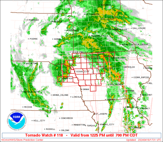
WW 118 TORNADO IA NE SD 161725Z - 170000Z

URGENT - IMMEDIATE BROADCAST REQUESTED
Tornado Watch Number 118
NWS Storm Prediction Center Norman OK
1225 PM CDT Tue Apr 16 2024

The NWS Storm Prediction Center has issued a

* Tornado Watch for portions of
  Western and Northern Iowa
  Northeast Nebraska
  Southeast South Dakota

* Effective this Tuesday afternoon and evening from 1225 PM until
  700 PM CDT.

* Primary threats include...
  A couple tornadoes possible
  Scattered large hail events to 1.5 inches in diameter possible
  Isolated damaging wind gusts to 60 mph possible

SUMMARY...A tornado/hail risk will exist through the afternoon as
far west as northeast Nebraska and southeast South Dakota near a
surface low, with other severe storms expected to develop into
additional parts of Iowa.

The tornado watch area is approximately along and 65 statute miles
north and south of a line from 30 miles north of Norfolk NE to 35
miles east of Fort Dodge IA. For a complete depiction of the watch
see the associated watch outline update (WOUS64 KWNS WOU8).

PRECAUTIONARY/PREPAREDNESS ACTIONS...

REMEMBER...A Tornado Watch means conditions are favorable for
tornadoes and severe thunderstorms in and close to the watch
area. Persons in these areas should be on the lookout for
threatening weather conditions and listen for later statements
and possible warnings.

&&

OTHER WATCH INFORMATION...CONTINUE...WW 116...WW 117...

AVIATION...Tornadoes and a few severe thunderstorms with hail
surface and aloft to 1.5 inches. Extreme turbulence and surface wind
gusts to 50 knots. A few cumulonimbi with maximum tops to 450. Mean
storm motion vector 22035.

...Guyer
Read more -
WW 0117 Status Updates
STATUS REPORT ON WW 117

THE SEVERE WEATHER THREAT CONTINUES ACROSS THE ENTIRE WATCH AREA.

..LEITMAN..04/16/24

ATTN...WFO...DVN...ARX...LSX...ILX...


STATUS REPORT FOR WT 117

SEVERE WEATHER THREAT CONTINUES FOR THE FOLLOWING AREAS

ILC001-009-011-015-017-057-067-071-073-085-095-109-123-125-131-
137-143-149-155-161-169-171-175-187-195-162140-

IL
.    ILLINOIS COUNTIES INCLUDED ARE

ADAMS                BROWN               BUREAU
CARROLL              CASS                FULTON
HANCOCK              HENDERSON           HENRY
JO DAVIESS           KNOX                MCDONOUGH
MARSHALL             MASON               MERCER
MORGAN               PEORIA              PIKE
PUTNAM               ROCK ISLAND         SCHUYLER
SCOTT                STARK               WARREN
WHITESIDE


IAC011-019-031-037-043-045-055-057-061-065-067-087-095-097-101-
103-105-107-111-113-115-139-163-177-183-162140-

IA
.    IOWA COUNTIES INCLUDED ARE

BENTON               BUCHANAN            CEDAR
CHICKASAW            CLAYTON             CLINTON
DELAWARE             DES MOINES          DUBUQUE
Read more -
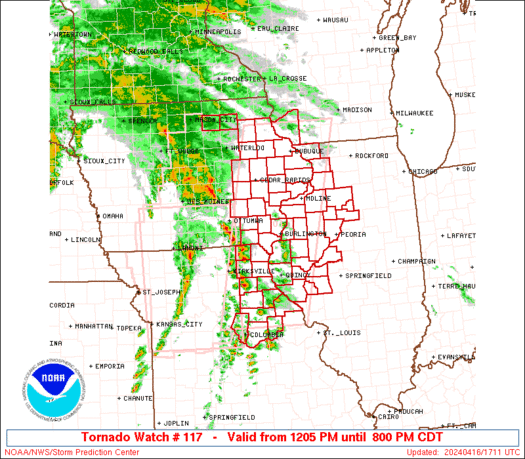
WW 117 TORNADO IA IL MO WI 161705Z - 170100Z
URGENT - IMMEDIATE BROADCAST REQUESTED
Tornado Watch Number 117
NWS Storm Prediction Center Norman OK
1205 PM CDT Tue Apr 16 2024

The NWS Storm Prediction Center has issued a

* Tornado Watch for portions of
  Eastern Iowa
  Western and Northwest Illinois
  Northeast Missouri
  Southwest Wisconsin

* Effective this Tuesday afternoon and evening from 1205 PM until
  800 PM CDT.

* Primary threats include...
  A few tornadoes likely with a couple intense tornadoes possible
  Scattered damaging wind gusts to 70 mph likely
  Scattered large hail and isolated very large hail events to 2
    inches in diameter possible

SUMMARY...Arcing bands and clusters of severe storms including
supercells will steadily move northeastward across the region
through the afternoon, with the potential for all hazards including
tornadoes, a couple of which could be strong.

The tornado watch area is approximately along and 60 statute miles
east and west of a line from 40 miles north of Dubuque IA to 75
miles south southwest of Quincy IL. For a complete depiction of the
watch see the associated watch outline update (WOUS64 KWNS WOU7).

PRECAUTIONARY/PREPAREDNESS ACTIONS...

REMEMBER...A Tornado Watch means conditions are favorable for
tornadoes and severe thunderstorms in and close to the watch
area. Persons in these areas should be on the lookout for
threatening weather conditions and listen for later statements
and possible warnings.

&&

OTHER WATCH INFORMATION...CONTINUE...WW 116...

AVIATION...Tornadoes and a few severe thunderstorms with hail
surface and aloft to 2 inches. Extreme turbulence and surface wind
gusts to 60 knots. A few cumulonimbi with maximum tops to 500. Mean
storm motion vector 23040.

...Guyer
Read more -
WW 0116 Status Updates
STATUS REPORT ON WW 116

SEVERE WEATHER THREAT CONTINUES RIGHT OF A LINE FROM 30 ESE SZL
TO 45 SW OTM TO 20 W DSM.

..LEITMAN..04/16/24

ATTN...WFO...DMX...EAX...


STATUS REPORT FOR WT 116

SEVERE WEATHER THREAT CONTINUES FOR THE FOLLOWING AREAS

IAC007-013-015-017-023-033-049-051-069-075-079-083-099-117-123-
125-127-135-153-157-169-171-179-181-197-162140-

IA
.    IOWA COUNTIES INCLUDED ARE

APPANOOSE            BLACK HAWK          BOONE
BREMER               BUTLER              CERRO GORDO
DALLAS               DAVIS               FRANKLIN
GRUNDY               HAMILTON            HARDIN
JASPER               LUCAS               MAHASKA
MARION               MARSHALL            MONROE
POLK                 POWESHIEK           STORY
TAMA                 WAPELLO             WARREN
WRIGHT


MOC001-041-053-089-121-175-197-162140-

MO
.    MISSOURI COUNTIES INCLUDED ARE

ADAIR                CHARITON            COOPER
HOWARD               MACON               RANDOLPH
SCHUYLER
Read more -
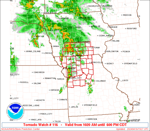
WW 116 TORNADO IA MO 161520Z - 162300Z
URGENT - IMMEDIATE BROADCAST REQUESTED
Tornado Watch Number 116
NWS Storm Prediction Center Norman OK
1020 AM CDT Tue Apr 16 2024

The NWS Storm Prediction Center has issued a

* Tornado Watch for portions of
  Southern Iowa
  Western and Northern Missouri

* Effective this Tuesday morning and evening from 1020 AM until
  600 PM CDT.

* Primary threats include...
  A few tornadoes and a couple intense tornadoes possible
  Scattered large hail and isolated very large hail events to 2
    inches in diameter possible
  Scattered damaging wind gusts to 70 mph possible

SUMMARY...Storms will likely continue to intensify and organize,
including supercells, as they further develop and move northeastward
across the region today, with steady destabilization into afternoon
as heating occurs and cloud breaks occur.

The tornado watch area is approximately along and 65 statute miles
east and west of a line from 25 miles west northwest of Knoxville IA
to 10 miles south southeast of Knob Noster MO. For a complete
depiction of the watch see the associated watch outline update
(WOUS64 KWNS WOU6).

PRECAUTIONARY/PREPAREDNESS ACTIONS...

REMEMBER...A Tornado Watch means conditions are favorable for
tornadoes and severe thunderstorms in and close to the watch
area. Persons in these areas should be on the lookout for
threatening weather conditions and listen for later statements
and possible warnings.

&&

AVIATION...Tornadoes and a few severe thunderstorms with hail
surface and aloft to 2 inches. Extreme turbulence and surface wind
gusts to 60 knots. A few cumulonimbi with maximum tops to 500. Mean
storm motion vector 23040.

...Guyer
Read more -
SPC 2000Z Day 1 Outlook
Day 1 Convective Outlook
NWS Storm Prediction Center Norman OK
0254 PM CDT Tue Apr 16 2024

Valid 162000Z - 171200Z

...THERE IS AN ENHANCED RISK OF SEVERE THUNDERSTORMS ACROSS THE
MIDWEST AND MIDDLE MISSISSIPPI VALLEY...

...SUMMARY...
Scattered severe thunderstorms are likely today, especially across
northern Missouri, Iowa, and northwestern Illinois. Large hail,
damaging winds, and tornadoes are expected. More isolated activity
could develop as far south as the Ozarks and Mid-South.

...Synopsis...
The previous forecast largely remains on track with only minor
modifications made to reflect convective trends across portions of
NE, KS, and western MO. Recent analyses show that the best kinematic
environment resides from central AR into MO and southern/southeast
IA. However, thermodynamic limitations (largely due to warm
temperatures in the 850-700 mb as sampled by the 18 UTC DVN and 19
UTC ILX soundings and modest mid-level lapse rates) and unfavorable
storm interactions have modulated convective intensity/organization
thus far. Further intensification remains possible through the
afternoon/early evening amid peak diurnal heating (see MCD 460 for
additional near-term details). Across far eastern NE into western
IA, cold temperatures aloft (supporting surface-based lifted indices
between -7 to -9 C) combined with plentiful ambient low-level
vorticity along surface boundaries continues to support a tornado
threat. See MCD 461 for additional details.

..Moore.. 04/16/2024

.PREV DISCUSSION... /ISSUED 1140 AM CDT Tue Apr 16 2024/

...Midwest/Middle Mississippi Valley...
Regenerative scattered showers and thunderstorms continue to occur
across western/northern Missouri into much of Iowa at late morning,
originating with a warm sector that narrows with north-northwestward
extent into southern Iowa and far east/northeast Nebraska in
vicinity of the surface low. Even while warm-sector cloud breaks
have been limited, steady early-spring heating and low-level
moistening is occurring with surface dewpoints rising through the
lower 60s F.

This development coincides with an intense/cyclonically curved 90+
kt polar jet and a low-level jet that will remain diurnally strong
(40+ kt). Modest cloud breaks aside, destabilization will be further
aided by a pocket of steep mid-level lapse rates and cold
temperatures aloft on the southeast side of the upper trough/low.
Scenario supports a risk for supercells especially across northern
Missouri into southern/eastern Iowa and northwest Illinois.

Steep mid-level lapse rates will aid in hail production, with a few
golf ball or 2+ inch diameter stones possible with the more robust
cores. Tornadoes will also be a concern, as the enhanced
boundary-layer flow and enlarged/curved hodographs associated with
the low-level jet will aid in updraft rotation. The main tornado
potential is still expected to be focused along/near the warm front
in southern/eastern Iowa where the stronger low-level shear is
forecast. A strong (EF2+) tornado is possible. Isolated to scattered
damaging winds are otherwise expected regionally.

Farther south toward the Ozarks and Mid-South, a potential for at
least isolated severe thunderstorms remains apparent into this
evening, with a moist/confluent regime near/ahead of the
eastward-advancing front. Mid-level lapse rates will remain limited.
However, steady low-level moistening will tend to counteract a
tendency for nocturnal boundary cooling, netting a scenario with
limited warm-sector inhibition tonight, supporting the possibility
of supercells capable of all severe hazards including a tornado
risk, even if severe storms remain relatively isolated overall.
Read more -
SPC 1730Z Day 2 Outlook
Day 2 Convective Outlook
NWS Storm Prediction Center Norman OK
1228 PM CDT Tue Apr 16 2024

Valid 171200Z - 181200Z

...THERE IS A SLIGHT RISK OF SEVERE THUNDERSTORMS NORTHEAST INDIANA
INTO SOUTHEAST LOWER MICHIGAN AND MUCH OF OHIO...

...SUMMARY...
Scattered severe thunderstorms are possible Wednesday afternoon and
evening from southern Lower Michigan into parts of the Ohio Valley.
A more isolated severe threat may materialize across parts of
Tennessee Valley into the Southwest as well as parts of the
east-central Plains and Ozark Plateau.

...Synopsis...
The upper-level wave and attendant surface low currently over the
central Plains/Midwest are forecast to weaken over the next 24-48
hours as they gradually lift to the northeast. A trailing surface
cold front associated with the low is forecast to push east across
the Great Lakes region through the day it becomes increasingly
influenced by mean westerly flow. This boundary should be the focus
for strong to severe thunderstorm development by late morning/early
afternoon across IN/OH and lower MI. Additional thunderstorm
development is anticipated by peak heating across portions of the TN
Valley as a residual outflow boundary migrates east. To the west
across the Plains, a warm advection regime should become established
by early evening as a surface low begins to deepen ahead of an
approaching upper-level wave. Isolated strong to severe
thunderstorms are possible within the warm advection regime across
parts of the Ozarks into the east-central Plains.

...Midwest/Great Lakes...
Broken cloud cover is anticipated Wednesday morning across the
Midwest/Great Lakes as a mid-level dry slot overspreads the region
in the wake of Tuesday night's convection. The north/northeast track
of the decaying surface low should allow for low to mid 60s
dewpoints to spread north into IN/OH and lower MI by late morning
ahead of the approaching cold front. Thunderstorm development may
occur by mid-morning across portions of IN, but the development and
intensification of any convection will be dependent on the degree of
subsidence within the dry slot. Diurnal heating of the low-level air
mass should allow for 1000-2000 J/kg SBCAPE by early afternoon with
decreasing inhibition. Consequently, more robust convection is
likely by early afternoon across lower MI into western OH.
Deep-layer flow off the front should favor initially discrete cells
within a broken line of storms with an attendant hail and tornado
risk. Steepening low-level lapse rates, combined with 40-50 knot
mid-level flow, should support an increasing damaging wind threat by
late afternoon. Upscale growth into one or more clusters is probable
by late afternoon into the evening hours across eastern OH and far
western PA given strong forcing along the front and similar storm
and boundary motions. Further south into the OH River Valley,
thunderstorm development is less certain given increasing
displacement from the stronger forcing for ascent. However, a
conditionally favorable environment for organized convection is
forecast, which should support a more isolated severe threat.

...Tennessee Valley region...
A residual outflow boundary from Tuesday night's convection is
expected to push east through the morning hours, reaching the
eastern TN Valley into northern AL/MS by peak heating. Thunderstorm
development and/or re-intensification is possible - especially
across AL/MS/GA where latest CAMs show reasonable agreement in
redevelopment as SBCAPE increases to around 1500 J/kg. While
low-level flow is forecast to be weak, 30-40 knot westerlies aloft,
combined with steepening low-level lapse rates by late afternoon,
should support a few stronger cells/clusters with an attendant
hail/wind risk.

...Southwest Missouri to Northeast Kansas...
An upper disturbance currently approaching northern MT is forecast
to migrate southeast over the next 48 hours. Surface pressure falls
over the Plains in response to the approach of this feature will
strengthen southerly low/mid-level winds on the western periphery of
a warm/moist air mass over the southern Plains/lower MS Valley -
especially by early evening as the nocturnal jet strengthens.
Concurrently, a cold air mass will begin migrating south along the
High Plains. Thunderstorms may develop within the warm advection
regime on the northern fringe of the returning moisture during the
00-06 UTC period across parts of the Ozark Plateau. A second round
is probable later overnight (during the 08-12 UTC period) as the
cold front impinges on the returning moisture across northeast KS.
For both regimes, sufficient deep-layer flow should be in place to
support organized cells with a severe hail risk.

..Moore.. 04/16/2024
Read more -
SPC 1630Z Day 1 Outlook
Day 1 Convective Outlook
NWS Storm Prediction Center Norman OK
1140 AM CDT Tue Apr 16 2024

Valid 161630Z - 171200Z

...THERE IS AN ENHANCED RISK OF SEVERE THUNDERSTORMS ACROSS THE
MIDWEST AND MIDDLE MISSISSIPPI VALLEY...

...SUMMARY...
Scattered severe thunderstorms are likely today, especially across
northern Missouri, Iowa, and northwestern Illinois. Large hail,
damaging winds, and tornadoes are expected. More isolated activity
could develop as far south as the Ozarks and Mid-South.

...Midwest/Middle Mississippi Valley...
Regenerative scattered showers and thunderstorms continue to occur
across western/northern Missouri into much of Iowa at late morning,
originating with a warm sector that narrows with north-northwestward
extent into southern Iowa and far east/northeast Nebraska in
vicinity of the surface low. Even while warm-sector cloud breaks
have been limited, steady early-spring heating and low-level
moistening is occurring with surface dewpoints rising through the
lower 60s F.

This development coincides with an intense/cyclonically curved 90+
kt polar jet and a low-level jet that will remain diurnally strong
(40+ kt). Modest cloud breaks aside, destabilization will be further
aided by a pocket of steep mid-level lapse rates and cold
temperatures aloft on the southeast side of the upper trough/low.
Scenario supports a risk for supercells especially across northern
Missouri into southern/eastern Iowa and northwest Illinois.

Steep mid-level lapse rates will aid in hail production, with a few
golf ball or 2+ inch diameter stones possible with the more robust
cores. Tornadoes will also be a concern, as the enhanced
boundary-layer flow and enlarged/curved hodographs associated with
the low-level jet will aid in updraft rotation. The main tornado
potential is still expected to be focused along/near the warm front
in southern/eastern Iowa where the stronger low-level shear is
forecast. A strong (EF2+) tornado is possible. Isolated to scattered
damaging winds are otherwise expected regionally.

Farther south toward the Ozarks and Mid-South, a potential for at
least isolated severe thunderstorms remains apparent into this
evening, with a moist/confluent regime near/ahead of the
eastward-advancing front. Mid-level lapse rates will remain limited.
However, steady low-level moistening will tend to counteract a
tendency for nocturnal boundary cooling, netting a scenario with
limited warm-sector inhibition tonight, supporting the possibility
of supercells capable of all severe hazards including a tornado
risk, even if severe storms remain relatively isolated overall.

..Guyer/Bentley.. 04/16/2024
Read more -
Flood Warning issued April 16 at 10:48AM EDT until April 19 at 5:36PM EDT by NWS Tallahassee FL
-
Flood Warning issued April 16 at 10:47AM EDT until April 17 at 3:00PM EDT by NWS Tallahassee FL
-
Flood Warning issued April 16 at 10:20AM EDT by NWS Jacksonville FL
-
Flood Warning issued April 16 at 10:03AM EDT until April 19 at 6:00PM EDT by NWS Charleston SC
-
Flood Warning issued April 16 at 10:03AM EDT until April 18 at 11:00AM EDT by NWS Charleston SC
-
Flood Warning issued April 16 at 9:05AM EDT by NWS Jacksonville FL
-
Flood Warning issued April 16 at 9:05AM EDT until April 20 at 2:00AM EDT by NWS Jacksonville FL
-
Flood Warning issued April 16 at 9:05AM EDT until April 18 at 5:01AM EDT by NWS Jacksonville FL
-
SPC 1300Z Day 1 Outlook
Day 1 Convective Outlook
NWS Storm Prediction Center Norman OK
0742 AM CDT Tue Apr 16 2024

Valid 161300Z - 171200Z

...THERE IS AN ENHANCED RISK OF SEVERE THUNDERSTORMS ACROSS PARTS OF
IOWA...NORTHERN MISSOURI...AND NORTHWESTERN ILLINOIS...

...SUMMARY...
Scattered severe thunderstorms appear likely today, centered mostly
over northern Missouri, Iowa, and northwestern Illinois. Large hail,
damaging winds, and tornadoes should occur in this corridor. More
isolated activity could develop as far south as the Ozarks of
northern Arkansas.

...Synopsis...
An upper trough/low over the central Plains this morning will
continue to eject east-northeastward across the mid MO Valley and
Upper Midwest through tonight. A 70-90 kt mid-level jet will
overspread parts of the Midwest through the day, contributing to
substantial deep-layer shear and thunderstorm organization. At the
surface, a 990 mb low over central NE will likewise develop
east-northeastward through the day in tandem with the upper wave. A
warm front should lift northward across parts of the Midwest, with
generally low to mid 60s surface dewpoints present across the warm
sector as far south as the Ozarks. A composite Pacific cold
front/dryline will move quickly eastward from the southern/central
Plains into the mid Ms Valley by this evening. This boundary should
stall across the southern Plains, and may begin to lift northward
late tonight.

...Midwest/Mid Mississippi Valley...
A large area of showers and thunderstorms is ongoing this morning
from parts of eastern KS/NE/SD into IA. Much of this activity across
the central Plains is being driven by large-scale ascent associated
with the ejecting upper trough/low, along with strong warm/moist
advection with a 40-50 kt southerly low-level jet. As this
convection continues to spread eastward this morning in tandem with
the migrating low-level jet axis, it will probably become more
elevated, especially as it moves into northern MO and IA and a less
unstable airmass to the north of the warm front. Still, an isolated
severe threat may persist in the short term with these
thunderstorms. The effect of this early-day convection on robust
destabilization in its wake along/ahead of the cold front remains a
concern and potentially limiting factor for additional severe
thunderstorm development this afternoon. Even so, most guidance,
including multiple recent runs of the RAP, shows a narrow corridor
of weak to moderate instability developing along/south of the warm
front in IA, and ahead of the cold front sweeping eastward across
MO/IA. This re-destabilization should be aided by a pocket of steep
mid-level lapse rates and cold temperatures aloft on the southeast
side of the upper trough/low.

Assuming that low to mid 60s surface dewpoints and modest daytime
heating can aid in this instability actually materializing, then a
risk for supercells should exist over parts of IA, northern MO, and
northwestern IL. Both low-level and deep-layer shear appear strong
enough for supercells. Steep lapse rates will aid in hail
production, with some chance for 2+ inch diameter stones with the
more robust cores. Tornadoes will also be a concern, as the enhanced
boundary-layer flow and enlarged/curved hodographs associated with a
the low-level jet will aid in updraft rotation. The best tornado
potential will probably be focused along/near the warm front in IA,
where the greatest low-level shear is forecast. Here, a strong
tornado appears possible. Isolated to scattered damaging winds may
also occur.

Farther south into the Ozarks and Mid-South, the potential for
severe thunderstorms appears more conditional. Various NAM/RAP
forecast soundings exhibit generally poor lapse rates, with at least
weak inhibition through much of the period. Given these regions
displacement from the upper trough/low to the north, it remains
unclear how robust updrafts will be in a more marginal low/mid-level
lapse rate environment. Still, have maintained the Slight Risk into
parts of the lower MS Valley, but convection may struggle to
intensify this afternoon/evening.

..Gleason/Grams.. 04/16/2024
Read more -
WW 0115 Status Updates
STATUS REPORT ON WW 115

SEVERE WEATHER THREAT CONTINUES RIGHT OF A LINE FROM 45 SSW EMP
TO 40 SSW FNB.

FOR ADDITIONAL INFORMATION SEE MESOSCALE DISCUSSION 0456.

..GRAMS..04/16/24

ATTN...WFO...ICT...TOP...


STATUS REPORT FOR WT 115

SEVERE WEATHER THREAT CONTINUES FOR THE FOLLOWING AREAS

KSC001-003-013-031-045-059-073-085-087-111-139-177-197-207-
161340-

KS
.    KANSAS COUNTIES INCLUDED ARE

ALLEN                ANDERSON            BROWN
COFFEY               DOUGLAS             FRANKLIN
GREENWOOD            JACKSON             JEFFERSON
LYON                 OSAGE               SHAWNEE
WABAUNSEE            WOODSON


THE WATCH STATUS MESSAGE IS FOR GUIDANCE PURPOSES ONLY.  PLEASE
REFER TO WATCH COUNTY NOTIFICATION STATEMENTS FOR OFFICIAL
INFORMATION ON COUNTIES...INDEPENDENT CITIES AND MARINE ZONES
CLEARED FROM SEVERE THUNDERSTORM AND TORNADO WATCHES.
Read more -
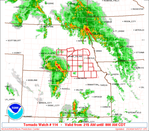
WW 115 TORNADO KS 160930Z - 161400Z
URGENT - IMMEDIATE BROADCAST REQUESTED
Tornado Watch Number 115
NWS Storm Prediction Center Norman OK
430 AM CDT Tue Apr 16 2024

The NWS Storm Prediction Center has issued a

* Tornado Watch for portions of
  Eastern Kansas

* Effective this Tuesday morning from 430 AM until 900 AM CDT.

* Primary threats include...
  A few tornadoes and a couple intense tornadoes possible
  Scattered large hail and isolated very large hail events to 2
    inches in diameter possible
  Isolated damaging wind gusts to 70 mph possible

SUMMARY...Supercells capable of producing all severe hazards will
move eastward this morning.

The tornado watch area is approximately along and 45 statute miles
east and west of a line from 35 miles north northeast of Manhattan
KS to 45 miles south of Emporia KS. For a complete depiction of the
watch see the associated watch outline update (WOUS64 KWNS WOU5).

PRECAUTIONARY/PREPAREDNESS ACTIONS...

REMEMBER...A Tornado Watch means conditions are favorable for
tornadoes and severe thunderstorms in and close to the watch
area. Persons in these areas should be on the lookout for
threatening weather conditions and listen for later statements
and possible warnings.

&&

OTHER WATCH INFORMATION...CONTINUE...WW 114...

AVIATION...Tornadoes and a few severe thunderstorms with hail
surface and aloft to 2 inches. Extreme turbulence and surface wind
gusts to 60 knots. A few cumulonimbi with maximum tops to 500. Mean
storm motion vector 22035.

...Gleason
Read more -
WW 0114 Status Updates
STATUS REPORT ON WW 114

SEVERE WEATHER THREAT CONTINUES RIGHT OF A LINE FROM 40 NW TOP TO
35 W BIE TO 10 SSW OLU.

WW 114 IS SCHEDULED TO EXPIRE AT 161300Z.

FOR ADDITIONAL INFORMATION SEE MESOSCALE DISCUSSION 0456.

..GRAMS..04/16/24

ATTN...WFO...TOP...OAX...GID...


STATUS REPORT FOR WT 114

SEVERE WEATHER THREAT CONTINUES FOR THE FOLLOWING AREAS

IAC071-085-129-155-161300-

IA
.    IOWA COUNTIES INCLUDED ARE

FREMONT              HARRISON            MILLS
POTTAWATTAMIE


KSC131-161300-

KS
.    KANSAS COUNTIES INCLUDED ARE

NEMAHA


NEC021-023-025-037-039-053-055-067-097-109-127-131-133-147-151-
153-155-159-167-177-161300-

NE
Read more


SPC Tornado Watch 118 Status Reports
in Storm Prediction Center RSS Feed
Posted
View the full article