


NorthGeorgiaWX
-
Posts
34,537 -
Joined
-
Last visited
-
Days Won
1,499
Content Type
Profiles
Blogs
Forums
Gallery
Events
Store
Downloads
Posts posted by NorthGeorgiaWX
-
-
WW 147 TORNADO IA KS MO 271840Z - 280200Z

URGENT - IMMEDIATE BROADCAST REQUESTED
Tornado Watch Number 147
NWS Storm Prediction Center Norman OK
140 PM CDT Sat Apr 27 2024

The NWS Storm Prediction Center has issued a

* Tornado Watch for portions of
  Southern Iowa
  Northeast Kansas
  Northern Missouri

* Effective this Saturday afternoon and evening from 140 PM until
  900 PM CDT.

* Primary threats include...
  A few tornadoes likely with a couple intense tornadoes possible
  Scattered large hail and isolated very large hail events to 2
    inches in diameter likely
  Scattered damaging winds likely with isolated significant gusts
    to 75 mph possible

SUMMARY...Thunderstorms will continue to develop this afternoon
along a surface boundary lying across northern Missouri and southern
Iowa.  Large hail and damaging winds are possible, along with a few
tornadoes in the strongest cells.

The tornado watch area is approximately along and 45 statute miles
north and south of a line from 35 miles west of Saint Joseph MO to
30 miles south of Ottumwa IA. For a complete depiction of the watch
see the associated watch outline update (WOUS64 KWNS WOU7).

PRECAUTIONARY/PREPAREDNESS ACTIONS...

REMEMBER...A Tornado Watch means conditions are favorable for
tornadoes and severe thunderstorms in and close to the watch
area. Persons in these areas should be on the lookout for
threatening weather conditions and listen for later statements
and possible warnings.

&&

OTHER WATCH INFORMATION...CONTINUE...WW 145...WW 146...

AVIATION...Tornadoes and a few severe thunderstorms with hail
surface and aloft to 2 inches. Extreme turbulence and surface wind
gusts to 65 knots. A few cumulonimbi with maximum tops to 500. Mean
storm motion vector 25030.

...Hart
Read more -
SPC Day 2 Fire Weather Outlook
Day 2 Fire Weather Outlook NWS Storm Prediction Center Norman OK 0109 PM CDT Sat Apr 27 2024 Valid 281200Z - 291200Z The previous forecast (see below) remains on track, with only slight modifications made to the ongoing Elevated highlights to reflect the latest guidance consensus. ..Squitieri.. 04/27/2024 .PREV DISCUSSION... /ISSUED 0159 AM CDT Sat Apr 27 2024/ ...Synopsis... Elevated fire weather conditions will be possible Sunday afternoon across eastern New Mexico and far western Texas, where a belt of increased mid-level flow will be in place with weak surface troughing. This will allow for relative humidity reductions to around 10-20 percent amid surface winds 10-15 mph (locally as high as 20 mph). Fuels in this region will likely see drying on D1 Saturday, but overall coverage of any Critical winds should remain low enough to preclude the need for a Critical delineation at this time. ...Please see www.spc.noaa.gov/fire for graphic product...
Read more -
Public Severe Weather Outlook
PUBLIC SEVERE WEATHER OUTLOOK NWS STORM PREDICTION CENTER NORMAN OK 0649 AM CDT SAT APR 27 2024 ...Severe thunderstorms expected over parts of the southern and central Great Plains today through tonight... * LOCATIONS... Oklahoma North Texas Kansas Western Missouri * HAZARDS... Several tornadoes, a few intense Widespread large hail, some baseball size Scattered damaging winds, some hurricane force * SUMMARY... Numerous severe thunderstorms are likely today and tonight across the southern and central Plains into the lower to mid Missouri Valley. The greatest potential for severe storms will be from north Texas into Oklahoma and southeast Kansas, where strong tornadoes, very large hail over 2 inches in diameter and widespread damaging winds (some over 70 mph), are expected to occur. A broader area of severe threat will extend from south-central Texas north-northeastward to the Great Lakes. Preparedness actions... Review your severe weather safety procedures for the possibility of dangerous weather today. Stay tuned to NOAA Weather Radio, weather.gov, or other media for watches and warnings. A tornado watch means that conditions are favorable for tornadoes to form during the next several hours. If a tornado warning is issued for your area, move to a place of safety, ideally in a basement or interior room on the lowest floor of a sturdy building.
Read more -
WW 0144 Status Updates
STATUS REPORT ON WW 144 THE SEVERE WEATHER THREAT CONTINUES ACROSS THE ENTIRE WATCH AREA. FOR ADDITIONAL INFORMATION SEE MESOSCALE DISCUSSION 0539. ..GRAMS..04/27/24 ATTN...WFO...OUN...LUB...AMA... STATUS REPORT FOR WT 144 SEVERE WEATHER THREAT CONTINUES FOR THE FOLLOWING AREAS OKC003-009-011-039-043-045-047-053-055-057-059-065-075-093-129- 141-149-151-153-271740- OK . OKLAHOMA COUNTIES INCLUDED ARE ALFALFA BECKHAM BLAINE CUSTER DEWEY ELLIS GARFIELD GRANT GREER HARMON HARPER JACKSON KIOWA MAJOR ROGER MILLS TILLMAN WASHITA WOODS WOODWARD TXC075-087-101-155-191-197-345-483-487-271740- TX . TEXAS COUNTIES INCLUDED ARE CHILDRESS COLLINGSWORTH COTTLE FOARD HALL HARDEMAN MOTLEY WHEELER WILBARGER
Read more -
Rip Current Statement issued April 27 at 2:33AM EDT until April 28 at 8:00PM EDT by NWS Jacksonville FL
-
SPC 1730Z Day 2 Outlook
Day 2 Convective Outlook NWS Storm Prediction Center Norman OK 1230 PM CDT Fri Apr 26 2024 Valid 271200Z - 281200Z ...THERE IS AN ENHANCED RISK OF SEVERE THUNDERSTORMS ACROSS PARTS OF THE SOUTHERN/CENTRAL PLAINS... ...SUMMARY... Numerous severe thunderstorms are likely Saturday into Saturday night. The greatest severe threat is currently anticipated across parts of the central and southern Plains, where very large hail, damaging winds, and multiple strong tornadoes will be possible. A broader area of potential threat will extend from south-central Texas north-northeastward to the Great Lakes. ...Synopsis... A shortwave trough over the Upper Midwest Saturday morning should further de-amplify as it moves across the Great Lakes through the day in tandem with a weakening surface low. A large-scale upper trough over the Southwest will eject across the southern/central Plains through the period, while an attendant 50-70 kt southwesterly mid-level jet overspreads these same regions. At the surface, lee cyclogenesis is expected to occur over western KS through Saturday afternoon, before the low eventually develops towards central KS Saturday night. A dryline will extend southward from this low across the southern/central High Plains, and a warm front will extend northeastward from the low across the central Plains into the Upper Midwest. ...Southern/Central Plains... Most guidance develops thunderstorms early Saturday morning across northwest TX into central OK. This activity will likely be related to a subtle mid-level shortwave trough ejecting northeastward across the southern High Plains, along with ascent along a westward retreating dryline and warm/moist advection attendant to a southerly low-level jet. Steep lapse rates aloft fostering moderate to strong MUCAPE, along with sufficient deep-layer shear, should support some large hail threat with this early day convection. The potential for these morning thunderstorms to continue into the afternoon across central/eastern OK and eastern KS remains uncertain. Even so, some severe threat may persist with this activity as it spreads eastward. Fairly meridional flow at low/mid levels suggests a messy mode may develop, with numerous thunderstorm mergers/interactions possible. In the wake of this activity, it still appears likely that substantial destabilization will occur along/east of the dryline and south of the warm front, with daytime heating of a moist low-level airmass supporting MLCAPE of 2000-3500 J/kg from north-central KS southward into parts of western OK and northwest TX. As ascent with the ejecting upper trough overspreads this warm sector, multiple attempts at supercell development will likely occur both along the dryline and warm front, as 40-50 kt of deep-layer shear promotes robust thunderstorm organization. Any supercells that can form and persist will be capable of producing very large hail in excess of 2 inches in diameter. With time Saturday evening, a steadily strengthening low-level jet will foster increased low-level shear, and greater tornado potential. Multiple strong tornadoes appear possible during the late afternoon to early evening time frame, as effective SRH of 150-250+ m2/s2 supports low-level updraft rotation. Locally greater low-level shear will probably be realized along/near the warm front Saturday evening, and the Enhanced Risk has been expanded slightly northward to include more of south-central/southeast NE. It remains unclear how long a discrete mode will be able to be maintained, as a tendency for convection to grow upscale into one or more bowing clusters appears likely Saturday evening/night. As this mode transition occurs and convection spreads eastward, a greater threat for severe/damaging winds will probably be realized across the southern/central Plains. Due to the influence of the morning convection and potential for messy storm modes/convective evolution Saturday afternoon, confidence was not high enough to include greater tornado and/or hail probabilities across the southern/central Plains at this time. ...Northwest Kansas into Southwest Nebraska and Northeast Colorado... Low-level easterly flow will maintain modest low-level moisture within the post-frontal regime from northwest KS/southwest NE into northeast CO. Steep midlevel lapse rates will support MLCAPE increasing to around 500 J/kg, with veering wind profiles with height through mid levels supporting some potential for organized convection. A supercell or two could evolve within this regime, with an attendant threat of large hail and possibly a tornado. ...Upper Midwest/Great Lakes... A mostly separate regime of at least isolated severe thunderstorm potential remains evident along/ahead of the front from eastern IA into parts of the Great Lakes region. While the influence of the weakening shortwave trough initially over the Upper Great Lakes may remain mostly displaced to the north of the warm sector, diurnal heating/destabilization and gradually lessening convective inhibition may support isolated storm development by late afternoon along the front. Deep-layer shear will remain sufficient for updraft organization, supporting a potential for supercells and/or stronger clusters capable of producing severe hail, damaging gusts, and possibly a tornado or two. Some increase in storm coverage will be possible into the evening as the cold front moves southeastward. Thunderstorms should weaken overnight across this region, though a stronger cluster to two could move from eastern portions of the central Plains toward the upper MS Valley before the end of the forecast period. ..Gleason.. 04/26/2024
Read more -
MD 0526 CONCERNING SEVERE POTENTIAL...TORNADO WATCH LIKELY FOR PARTS OF CENTRAL AND EASTERN NEBRASKA ...NORTHEAST KANSAS INTO SOUTHWESTERN IOWA.
Mesoscale Discussion 0526 NWS Storm Prediction Center Norman OK 1221 PM CDT Fri Apr 26 2024 Areas affected...parts of central and eastern Nebraska ...northeast Kansas into southwestern Iowa. Concerning...Severe potential...Tornado Watch likely Valid 261721Z - 261815Z Probability of Watch Issuance...95 percent SUMMARY...Scattered storm development appears likely on the dryline within central and eastern Nebraska early this afternoon. Supercells with large to very large hail and tornadoes are possible. A Tornado Watch is likely needed. DISCUSSION...Rapid destabilization is ongoing within the dry slot ahead of an upper trough moving into the central Plains. Visible imagery shows towering cumulus deepening along the bent back dryline from near Kearney, NE to the KS border. A pocket of low to mid 60s F surface dewpoints has remained sheltered from deeper vertical mixing due to lingering clouds near the surface low. As cloud breaks enlarge with the advection of dry mid-level air, insolation will support the removal of remaining MLCINH through the early afternoon. Area model sounding show 1500-2000 J/kg of MLCAPE with strongly veering wind profiles and 40-45 kt of effective shear. As large-scale ascent moves over early this afternoon, scattered supercell development is expected along the dryline. Hi-res guidance and observational trends are in good agreement that an arc of storms could develop as early as 18-19z and spread northeastward into east eastern NE and eventually western IA. With backed low-level flow near the low/warm front and strongly veering wind profiles overlapping with large low-level buoyancy, supercells appear likely to pose a risk for tornadoes (possibly significant) in addition to large to very large hail. The southern and eastern extent of the threat remains somewhat uncertain as cloud debris and outflow from the morning convection are still in place. Still, gradual destabilization is likely this afternoon as ascent and clearing arrive from the west. A tornado watch will likely be needed early this afternoon. ..Lyons/Hart.. 04/26/2024 ...Please see www.spc.noaa.gov for graphic product... ATTN...WFO...DMX...EAX...FSD...OAX...TOP...GID...LBF... LAT...LON 42649674 42299596 41909541 41399524 40729519 40129527 39949546 39889575 39859598 39829630 39859679 39889720 39979749 40089770 40329792 40639812 40869834 40979860 41019894 41179902 41629913 42149910 42239906 42579833 42739771 42749712 42649674Read more -
SPC 1630Z Day 1 Outlook
Day 1 Convective Outlook CORR 1 NWS Storm Prediction Center Norman OK 1142 AM CDT Fri Apr 26 2024 Valid 261630Z - 271200Z ...THERE IS AN ENHANCED RISK OF SEVERE THUNDERSTORMS THIS AFTERNOON AND EVENING FROM EASTERN NEBRASKA/WESTERN IOWA SOUTHWARD TO EASTERN OKLAHOMA AND NORTHEAST TEXAS... CORRECTED FOR WEB GRAPHICS ERROR ...SUMMARY... A few tornadoes, including a couple of strong tornadoes, isolated very large hail (greater than 2 inch diameter) and isolated wind damage will be possible, mainly this afternoon/evening from northeast Kansas/southeast Nebraska into western Missouri, eastern Oklahoma, western Arkansas, and northeast Texas. ...NE/IA/MO/KS... Water vapor loop shows a strong shortwave trough rotating across KS/NE. A deep surface low is analyzed ahead of this trough over central NE, with a dryline extending southward into central KS. A corridor of ample low-level moisture is present ahead of the dryline over southeast NE/northeast KS, where daytime heating will lead to moderate MLCAPE values and rapid thunderstorm development by mid-afternoon. Backed low-level winds and favorable shear profiles will promote supercells in the bent-back region of the low, with very large hail and tornadoes possible. These storms will progress eastward into western IA and northwest MO through the early evening. A strong tornado or two is possible in this region. ...OK/MO/AR... A large nocturnal MCS that affected much of OK has quickly weakened and departed, with rapid northward return of low-level moisture occurring in the wake of the system. By mid-afternoon, mid-upper 60s dewpoints are expected along the dryline over east-central OK. Forecast soundings show very steep mid-level lapse rates and favorable shear profiles to promote discrete supercells capable of all severe hazards, including very large hail and strong tornadoes. Storms will track northeastward into southwest MO and northwest AR this evening. CAM guidance varies on coverage of storms, but parameters appear quite strong and warrant an upgrade to ENH given the conditional risk of significant severe weather. ...Northeast TX... A third area of significant risk of severe storms lies across parts of northeast and east-central TX today. A cluster of severe/supercell storms has formed this morning to the west of Waco, TX. These storms are expected to increase in coverage through the afternoon and develop eastward across much of northeast TX. Forecast soundings show a very moist and unstable environment, with sufficient low-level and deep-layer shear for persistent supercell structures and risks of a few tornadoes and very large hail. Given the number of storms and the favorable environment, have also upgraded this narrow corridor to ENH. ..Hart.. 04/26/2024
Read more -
-
-
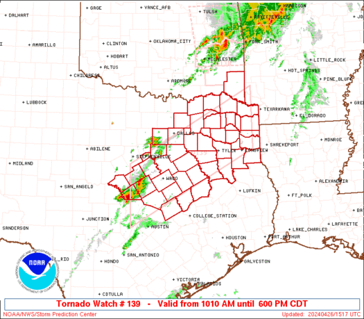
WW 139 TORNADO OK TX 261510Z - 262300Z
URGENT - IMMEDIATE BROADCAST REQUESTED Tornado Watch Number 139 NWS Storm Prediction Center Norman OK 1010 AM CDT Fri Apr 26 2024 The NWS Storm Prediction Center has issued a * Tornado Watch for portions of Southeast Oklahoma Central and Northeast Texas * Effective this Friday morning and evening from 1010 AM until 600 PM CDT. * Primary threats include... A few tornadoes possible Scattered large hail and isolated very large hail events to 2.5 inches in diameter possible Scattered damaging wind gusts to 70 mph possible SUMMARY...Thunderstorms are expected increase in coverage and intensity through the late morning and afternoon, with a few severe thunderstorms possible. Large hail, damaging winds, and a few tornadoes may occur. The tornado watch area is approximately along and 60 statute miles north and south of a line from 50 miles west of Temple TX to 65 miles north northeast of Longview TX. For a complete depiction of the watch see the associated watch outline update (WOUS64 KWNS WOU9). PRECAUTIONARY/PREPAREDNESS ACTIONS... REMEMBER...A Tornado Watch means conditions are favorable for tornadoes and severe thunderstorms in and close to the watch area. Persons in these areas should be on the lookout for threatening weather conditions and listen for later statements and possible warnings. && OTHER WATCH INFORMATION...CONTINUE...WW 138... AVIATION...Tornadoes and a few severe thunderstorms with hail surface and aloft to 2.5 inches. Extreme turbulence and surface wind gusts to 60 knots. A few cumulonimbi with maximum tops to 500. Mean storm motion vector 25030. ...HartRead more -
WW 0138 Status Updates
STATUS REPORT ON WW 138 SEVERE WEATHER THREAT CONTINUES RIGHT OF A LINE FROM 35 S MLC TO 20 SE MLC TO 25 ENE MLC TO 25 W RKR TO 20 NW RKR TO 30 WNW FSM TO 25 NNW FSM TO 30 SSW UMN. ..JEWELL..04/26/24 ATTN...WFO...TSA... STATUS REPORT FOR WT 138 SEVERE WEATHER THREAT CONTINUES FOR THE FOLLOWING AREAS OKC077-079-127-135-261440- OK . OKLAHOMA COUNTIES INCLUDED ARE LATIMER LE FLORE PUSHMATAHA SEQUOYAH THE WATCH STATUS MESSAGE IS FOR GUIDANCE PURPOSES ONLY. PLEASE REFER TO WATCH COUNTY NOTIFICATION STATEMENTS FOR OFFICIAL INFORMATION ON COUNTIES...INDEPENDENT CITIES AND MARINE ZONES CLEARED FROM SEVERE THUNDERSTORM AND TORNADO WATCHES.
Read more -
SPC 1300Z Day 1 Outlook
Day 1 Convective Outlook NWS Storm Prediction Center Norman OK 0753 AM CDT Fri Apr 26 2024 Valid 261300Z - 271200Z ...THERE IS AN ENHANCED RISK OF SEVERE THUNDERSTORMS THIS AFTERNOON/EVENING ACROSS NORTHEAST KS/SOUTHEAST NE/NORTHWEST MO/SOUTHWEST IA... ...SUMMARY... A few tornadoes, including a couple of strong tornadoes, isolated very large hail (greater than 2 inch diameter) and isolated wind damage will be possible, mainly this afternoon/evening from northeast Kansas/southeast Nebraska into northwest Missouri and southwest Iowa. Occasional severe storms are expected farther south into Arkansas, eastern Oklahoma and northeast Texas. ...Mid MO Valley to TX through tonight... A complex surface pattern is evident this morning with a cyclone in northern KS, a trailing dryline/Pacific front into western OK, and the east edge of the warm sector demarcated by a warm front from eastern OK into eastern KS. An ongoing QLCS with occasional wind damage and tornado reports is moving across eastern OK near the warm front, with an area of rain-cooled/overturned in OK in the wake of these storms. Farther north, an undisturbed portion of the warm sector extends across central KS. The eastern OK convection will likely persist through the day toward western AR, with additional expansion of rain/thunderstorms farther northeast into southwest/central MO. The OK/AR portion of this convection will be the most likely to maintain access to the surface warm sector through the day, where a mix of bowing segments or embedded supercells will be possible with all hazards. The clouds/rain will slow the northeastward progress of the warm sector, and northward advection of the overturned airmass in OK will potentially impact the breadth and quality of the unstable warm sector this afternoon. Assuming sufficient recovery during the day, there will be a window of opportunity for tornadic supercells along the dryline this afternoon/evening starting in northeast KS/southeast NE and spreading into northwest MO/southwest IA. MLCAPE at or above 2000 J/kg, boundary-layer dewpoints in the mid 60s, and sufficiently long hodographs with low-level hodograph curvature (effective bulk shear in excess of 50 kt, and effective SRH of 200-300 m2/s2) suggest the potential for a couple of strong tornadoes with any persistent, semi-discrete supercells. Isolated very large hail (in excess of 2 inches in diameter) will also be possible, while the potential for a few damaging gusts will accompany any upscale growth into line segments this evening. Additional thunderstorm development will be possible today farther southwest into TX, in association with weak height falls on the southern fringe of the ejecting midlevel trough. The 12z FWD sounding showed only a weak cap, so the SLGT has been expanded some to the southwest to account for large hail/wind damage potential today. Storms will likely weaken by this evening as weak height rises commence and the remnant dryline begins to retreat to the west. ..Thompson/Guyer.. 04/26/2024
Read more -
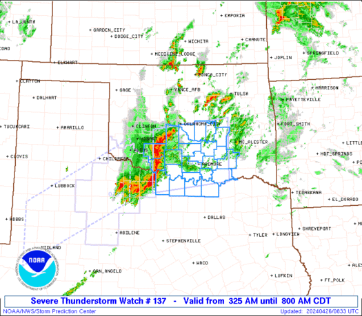
WW 0137 Status Updates
STATUS REPORT ON WW 137 SEVERE WEATHER THREAT CONTINUES RIGHT OF A LINE FROM 50 W GYI TO 10 WNW ADM TO 40 NNE ADM TO 15 N MLC. ..JEWELL..04/26/24 ATTN...WFO...OUN...FWD... STATUS REPORT FOR WS 137 SEVERE WEATHER THREAT CONTINUES FOR THE FOLLOWING AREAS OKC005-013-019-029-063-069-085-095-099-123-261440- OK . OKLAHOMA COUNTIES INCLUDED ARE ATOKA BRYAN CARTER COAL HUGHES JOHNSTON LOVE MARSHALL MURRAY PONTOTOC THE WATCH STATUS MESSAGE IS FOR GUIDANCE PURPOSES ONLY. PLEASE REFER TO WATCH COUNTY NOTIFICATION STATEMENTS FOR OFFICIAL INFORMATION ON COUNTIES...INDEPENDENT CITIES AND MARINE ZONES CLEARED FROM SEVERE THUNDERSTORM AND TORNADO WATCHES.
Read more -
SPC 1630Z Day 1 Outlook
Day 1 Convective Outlook NWS Storm Prediction Center Norman OK 1124 AM CDT Thu Apr 25 2024 Valid 251630Z - 261200Z ...THERE IS AN ENHANCED RISK OF SEVERE THUNDERSTORMS THIS EVENING ACROSS WESTERN KS AND TONIGHT ACROSS NORTHWEST TX INTO CENTRAL OK... ...SUMMARY... Very large hail up to 3 inches in diameter and a strong tornado or two will be possible this evening across western Kansas. Large hail, damaging winds to 70 mph and a few tornadoes will be possible tonight from northwest Texas into central Oklahoma. ...Synopsis... Morning water vapor imagery shows a negatively-tilted shortwave trough rotating across UT/AZ, with an associated 70kt mid-level jet max moving into NM. This system will eject into the central/southern Plains this evening/tonight, resulting in multiple clusters of severe thunderstorm activity. ...Western KS... A quasi-stationary surface boundary extends from northwest CO into northwest KS. Visible imagery shows broken cloud cover across western KS this morning, with dewpoints in the low 60s to the south of the front. Strong heating will likely ensue through the afternoon, resulting in deepening mixing to the east of the dryline and eventual isolated thunderstorm development. CAM solutions differ significantly on coverage of convection, but it appears likely that at least isolated supercells will form along the dryline, capable of very large hail, damaging winds, and a few tornadoes (possibly strong). The confidence of initiation is much higher along the warm front from northeast CO into northwest KS, and forecast soundings along this corridor show strong low-level vertical shear supporting supercell structures. It is uncertain how far north these storms can remain surface-based, but there is an apparent tornado risk (possibly strong) along the immediate boundary and a large hail risk for some distance northward. This activity will likely spread into south-central NE after dark. ...TX Panhandle/Western OK... As the primary upper trough ejects this evening, large-scale height falls and forcing will overspread the dryline across the OK/TX Panhandles. Forecast soundings show a persistent capping inversion along the dryline, and CAM guidance generally shows very isolated convective initiation. Any storm that forms will pose a risk of all severe hazards, including very large hail. Overnight, a strengthening low-level jet over west TX will likely lead to a large cluster of thunderstorm. These storms will track northeastward across northwest TX and into western/central OK in the pre-dawn hours. Large hail will be likely with these storms, but damaging winds and isolated tornadoes will also be a risk if a more organized linear MCS can evolve. ..Hart/Moore.. 04/25/2024
Read more -
SPC Day 1 Fire Weather Outlook
Day 1 Fire Weather Outlook NWS Storm Prediction Center Norman OK 1120 AM CDT Thu Apr 25 2024 Valid 251700Z - 261200Z ...CRITICAL FIRE WEATHER AREA FOR THE SOUTHERN HIGH PLAINS AND SOUTHERN NEW MEXICO... Elevated to critical conditions have started to develop across southeast New Mexico. Expect these conditions to expand/worsen through the day as mid-level flow strengthens and lee cyclogenesis continues. Expanded the Elevated delineation slightly farther north based on current and expected position of the front and dryline. Otherwise, no changes were necessary. See previous discussion below. ..Bentley.. 04/25/2024 .PREV DISCUSSION... /ISSUED 0114 AM CDT Thu Apr 25 2024/ ...Synopsis... A midlevel trough will track eastward across the Southwest, while an accompanying 60-70-kt midlevel southwesterly jet overspreads southern NM and the southern High Plains. This will promote rapid deepening of a lee cyclone over eastern CO, while a southward-extending dryline sharpens over west TX. This large-scale pattern evolution will yield an expansive area of critical fire-weather conditions across the aforementioned areas, with high-end critical conditions expected over eastern NM. ...Southern New Mexico and the Southern High Plains... Behind the sharpening dryline, strong downslope warming/drying and diurnal heating will contribute to a deep/dry boundary layer, characterized by surface temperatures in the mid/upper 80s and single-digit to lower-teens RH. Here, a tightening surface pressure gradient peripheral to the deepening lee cyclone, and mixing into the strong flow aloft, will support 25-35 mph sustained southwesterly surface winds (with gusts upwards of 45 mph). These conditions will yield an expansive area of high-end critical fire-weather conditions, given modestly receptive fuels. The overlap of strongest winds and lowest relative humidity is expected over eastern NM, where extremely critical meteorological conditions are likely. However, a lack of abundant and very dry fuels over the area precludes such highlights at this time. ...Please see www.spc.noaa.gov/fire for graphic product...
Read more -
SPC 1300Z Day 1 Outlook
Day 1 Convective Outlook NWS Storm Prediction Center Norman OK 0731 AM CDT Thu Apr 25 2024 Valid 251300Z - 261200Z ...THERE IS AN ENHANCED RISK OF SEVERE THUNDERSTORMS THIS EVENING ACROSS WESTERN KS AND TONIGHT ACROSS NORTHWEST TX INTO CENTRAL OK... ...SUMMARY... Very large hail up to 3 inches in diameter and a strong tornado or two will be possible this evening across western Kansas. Large hail up to 2.5 inches in diameter, damaging winds to 70 mph and a few tornadoes will be possible tonight from northwest Texas into central Oklahoma. ...Synopsis... A midlevel shortwave trough and associated 70 kt jet will eject northeastward toward western KS by late tonight and Friday morning. An associated lee cyclone is expected to deepen this afternoon across northeast CO, with a sharpening dryline arcing to its south across western KS and the TX/OK Panhandles. Farther east, a warm front will continue to move northward from OK into KS, though northward progress of the front will be slowed by elevated convection (posing an isolated large hail threat) that will reinforce the cool side of the boundary during the day. A somewhat bimodal threat distribution is expected - the warm sector in western KS and a second corridor overnight from northwest TX into OK. ...Western KS this afternoon/evening... An unstable warm sector will be present through this evening, with boundary-layer dewpoints in the 60s beneath steep midlevel lapse rates. The base of the elevated mixed layer will be relatively warm, suggesting the need for surface temperatures into the 80s on the immediate moist side of the dryline. The better potential for storm development this afternoon will be across western KS, where dryline parcel residence times will be longer and in closer proximity to the left-exit region of the approaching mid-upper jet. The initial dryline storms will likely become supercells capable of producing very large hail of 2-3 inches in diameter, and these storms could continue northeastward as elevated supercells atop the warm front. The potential for a strong tornado or two will increase this evening as the storms encounter richer low-level moisture and increasing low-level shear. However, the window of opportunity will not be particularly large given the presence of a rain-reinforced front to the northeast and increasing convective inhibition by late evening. ...Northwest TX into OK overnight... A general consensus of most overnight forecast guidance suggests a southern corridor of greater hail/wind threat starting early tonight just off the Caprock and then spreading northeastward over northwest TX into southwest/central OK early Friday morning. Thunderstorm initiation will become more probable by 03-06z in association with cooling/moistening at the base of the elevated mixed layer, coincident with the beginning of eastward movement of the dryline/Pacific cold front along the trailing influence of the ejecting midlevel trough. Storm mode will likely trend to clusters/line segments while spreading northeastward. Boundary-layer dewpoints approaching the upper 60s beneath steep midlevel lapse rates will contribute to MUCAPE in excess of 2000 J/kg through the overnight hours, which will favor the potential for both large hail (especially with any embedded supercells) and damaging winds of 60-70 mph. A few tornadoes may also occur with embedded circulations as low-level shear increases tonight. ...TX Panhandle/western OK this afternoon/evening... A conditionally favorable environment for supercells with very large hail and tornadoes will exist this afternoon/evening across the eastern TX Panhandle into western OK. The primary uncertainty here will be lingering convective inhibition and substantial uncertainty in storm coverage/location along the dryline. For these reasons, have lowered the overall severe threat, but maintained some conditional significant severe potential. ..Thompson/Kerr.. 04/25/2024
Read more -
No Mesoscale Discussions are in effect as of Thu Apr 25 12:01:02 UTC 2024.


SPC Tornado Watch 147
in Storm Prediction Center RSS Feed
Posted
URGENT - IMMEDIATE BROADCAST REQUESTED
Tornado Watch Number 147
NWS Storm Prediction Center Norman OK
140 PM CDT Sat Apr 27 2024

The NWS Storm Prediction Center has issued a

* Tornado Watch for portions of
  Southern Iowa
  Northeast Kansas
  Northern Missouri

* Effective this Saturday afternoon and evening from 140 PM until
  900 PM CDT.

* Primary threats include...
  A few tornadoes likely with a couple intense tornadoes possible
  Scattered large hail and isolated very large hail events to 2
    inches in diameter likely
  Scattered damaging winds likely with isolated significant gusts
    to 75 mph possible

SUMMARY...Thunderstorms will continue to develop this afternoon
along a surface boundary lying across northern Missouri and southern
Iowa.  Large hail and damaging winds are possible, along with a few
tornadoes in the strongest cells.

The tornado watch area is approximately along and 45 statute miles
north and south of a line from 35 miles west of Saint Joseph MO to
30 miles south of Ottumwa IA. For a complete depiction of the watch
see the associated watch outline update (WOUS64 KWNS WOU7).

PRECAUTIONARY/PREPAREDNESS ACTIONS...

REMEMBER...A Tornado Watch means conditions are favorable for
tornadoes and severe thunderstorms in and close to the watch
area. Persons in these areas should be on the lookout for
threatening weather conditions and listen for later statements
and possible warnings.

&&

OTHER WATCH INFORMATION...CONTINUE...WW 145...WW 146...

AVIATION...Tornadoes and a few severe thunderstorms with hail
surface and aloft to 2 inches. Extreme turbulence and surface wind
gusts to 65 knots. A few cumulonimbi with maximum tops to 500. Mean
storm motion vector 25030.

...Hart
Read moreView the full article