


NorthGeorgiaWX
-
Posts
34,537 -
Joined
-
Last visited
-
Days Won
1,499
Content Type
Profiles
Blogs
Forums
Gallery
Events
Store
Downloads
Posts posted by NorthGeorgiaWX
-
-
Special Weather Statement issued April 16 at 3:15AM EDT by NWS Peachtree City GA
-
SPC Day 2 Fire Weather Outlook

Day 2 Fire Weather Outlook
NWS Storm Prediction Center Norman OK
0200 AM CDT Tue Apr 16 2024

Valid 171200Z - 181200Z

...Synopsis...
In the mid levels, the flow pattern aloft is forecast to quickly
de-amplify and trend more zonal as the Midwest upper low rapidly
fills. Lingering strong westerly flow is likely over the southern
Rockies and High Plains through Wednesday. A weak lee cyclone is
expected to form over parts of eastern CO, supporting gusty surface
winds to the west across parts of eastern NM. Elevated fire-weather
conditions will be possible across parts of the southern High
Plains.

...Southern High Plains...
Elevated to brief locally critical fire-weather conditions appear
possible over parts of the southern High plains/Rockies as the
southeastern CO low develops on Wednesday afternoon. Winds of 15-20
mph will overlap low RH of around 10-15% atop dry fuels. Fire
weather concerns are most likely near the terrain to the southwest
of the surface low over eastern NM and far southern CO. Here winds
and downslope drying are expected to be the strongest with the
longest duration for a few hours during the afternoon.

..Lyons.. 04/16/2024

...Please see www.spc.noaa.gov/fire for graphic product...
Read more -
Flood Warning issued April 15 at 9:55PM EDT until April 19 at 11:00PM EDT by NWS Tallahassee FL
-
Flood Warning issued April 15 at 9:55PM EDT until April 17 at 12:30PM EDT by NWS Tallahassee FL
-
Flood Warning issued April 15 at 9:20PM EDT until April 19 at 8:00AM EDT by NWS Charleston SC
-
Flood Warning issued April 15 at 9:20PM EDT until April 18 at 2:00PM EDT by NWS Charleston SC
-
Flood Warning issued April 15 at 8:53PM EDT by NWS Jacksonville FL
-
-
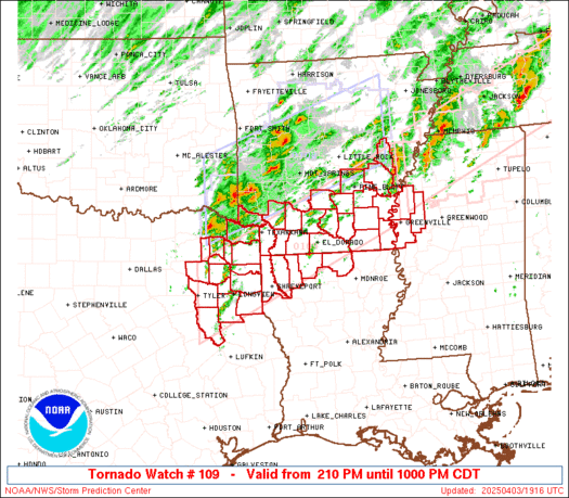
WW 109 SEVERE TSTM DC DE MD VA WV CW 151750Z - 160200Z
URGENT - IMMEDIATE BROADCAST REQUESTED
Severe Thunderstorm Watch Number 109
NWS Storm Prediction Center Norman OK
150 PM EDT Mon Apr 15 2024

The NWS Storm Prediction Center has issued a

* Severe Thunderstorm Watch for portions of
  District Of Columbia
  Southern Delaware
  Central and Eastern Maryland
  Virginia
  Central and Eastern West Virginia
  Coastal Waters

* Effective this Monday afternoon and evening from 150 PM until
  1000 PM EDT.

* Primary threats include...
  Scattered damaging wind gusts to 70 mph likely
  Scattered large hail and isolated very large hail events to 2
    inches in diameter possible

SUMMARY...Broken bands of strong to severe thunderstorms are
forecast to develop this afternoon and move east-southeast through
the mid evening.  Scattered severe gusts capable of wind damage will
be possible with the stronger cores and outflow winds.  Large hail
may accompany the early cellular storm activity.

The severe thunderstorm watch area is approximately along and 90
statute miles north and south of a line from 20 miles west northwest
of Beckley WV to 30 miles east southeast of Wallops VA. For a
complete depiction of the watch see the associated watch outline
update (WOUS64 KWNS WOU9).

PRECAUTIONARY/PREPAREDNESS ACTIONS...

REMEMBER...A Severe Thunderstorm Watch means conditions are
favorable for severe thunderstorms in and close to the watch area.
Persons in these areas should be on the lookout for threatening
weather conditions and listen for later statements and possible
warnings. Severe thunderstorms can and occasionally do produce
tornadoes.

&&

AVIATION...A few severe thunderstorms with hail surface and aloft to
2 inches. Extreme turbulence and surface wind gusts to 60 knots. A
few cumulonimbi with maximum tops to 500. Mean storm motion vector
29035.

...Smith
Read more -
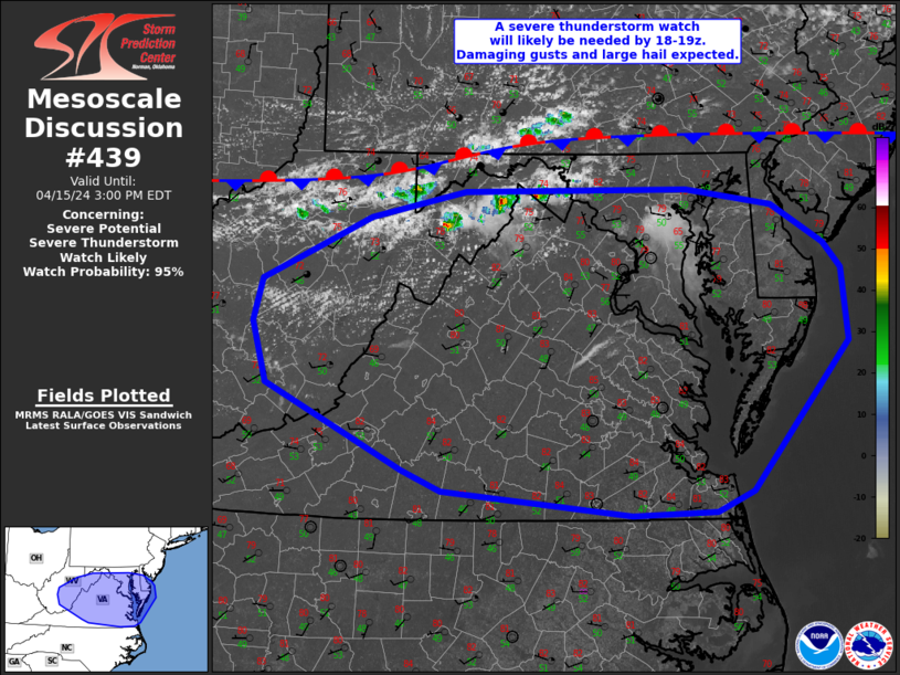
MD 0439 CONCERNING SEVERE POTENTIAL...SEVERE THUNDERSTORM WATCH LIKELY FOR PORTIONS OF WEST VIRGINIA...VIRGINIA...MARYLAND...AND DELAWARE
Mesoscale Discussion 0439
NWS Storm Prediction Center Norman OK
1203 PM CDT Mon Apr 15 2024

Areas affected...portions of West
Virginia...Virginia...Maryland...and Delaware

Concerning...Severe potential...Severe Thunderstorm Watch likely

Valid 151703Z - 151900Z

Probability of Watch Issuance...95 percent

SUMMARY...Thunderstorm activity is expected to increase by 3-4pm
EDT. Damaging gusts to 60-70 mph and large hail to 1.5 inches in
diameter will be possible through early evening.

DISCUSSION...Gradual destabilization is occurring from west to east
early this afternoon across the MCD region. Increasing cumulus
development is noted over the past hour across the higher terrain of
West Virginia into northern Virginia as temperatures have warmed
into the 70s to low 80s. The 12z MPAS-HT high-res guidance appears
to have the best handle on morning convection across the region, and
in the expected convective evolution through early evening. Based on
this guidance, and current observed trends, thunderstorm activity is
expected to increase by 19-20z/3-4pm EDT near/south of a residual
frontal boundary draped west to east across the region. This
development will be aided by continued heating/destabilization,
increasing midlevel moisture and a very steep low and midlevel lapse
rate environment (midlevel lapse rates around 8 C/km with southward
extent across VA).

While low-level winds will remain light, a belt of 30-40 kt midlevel
flow will foster effective shear magnitudes suitable for organized
convection. Initial cellular activity will pose a risk for large
hail and strong gusts. Meanwhile, a deeply mixed boundary-layer with
inverted-v sub-cloud thermodynamic profiles suggest strong outflow
winds will occur with this activity and clustering is likely to
occur via outflow interactions. A damaging wind threat will increase
with southeastward extent across Virginia toward the Chesapeake Bay
vicinity where steep low-level lapse rates and DCAPE over 1000 J/kg
will be focused.

A severe thunderstorm watch will likely be needed for portions of
the MCD vicinity by 18-19z.

..Leitman/Smith.. 04/15/2024

...Please see www.spc.noaa.gov for graphic product...

ATTN...WFO...PHI...AKQ...LWX...RNK...PBZ...RLX...

LAT...LON   39387892 39417647 39277553 38927496 38717477 38077471
            36797576 36617617 36577708 36797916 36977959 37708109
            38248124 38618114 38868058 39157996 39387892
Read more -
SPC Day 1 Fire Weather Outlook
Day 1 Fire Weather Outlook
NWS Storm Prediction Center Norman OK
1131 AM CDT Mon Apr 15 2024

Valid 151700Z - 161200Z

...CRITICAL FIRE WEATHER AREA FOR CENTRAL AND SOUTHERN HIGH
PLAINS...

Morning observed soundings within the High Plains region showed
shallow moisture along with a shallow temperature inversion. This
should allow surface temperatures to rapidly rise into the afternoon
along with moisture mixing out quite efficiently. Widespread
critical fire weather is expected today. Extremely critical
conditions appear probable at least on a localized basis.

Within the Missouri Valley, morning surface observations already
show ongoing elevated to borderline critical conditions, which is
ahead of even the drier/windier deterministic model solutions. Given
pockets of receptive fuels, particularly with southwestern extent,
several hours of elevated to locally critical conditions are
possible. RH should eventually increase from southwest to northeast
as the warm front lifts northward with time.

..Wendt.. 04/15/2024

.PREV DISCUSSION... /ISSUED 0202 AM CDT Mon Apr 15 2024/

...Synopsis...
An upper low and strong jet streak are forecast to intensify and
eject eastward over the Great Plains today and tonight. A lee low
should rapidly deepen over central High Plains with surface pressure
falls and the strong flow aloft bolstering strong surface winds over
much of the Plains. Hot and dry surface conditions atop drying fuels
will allow for widespread critical and localized extremely critical
fire-weather conditions.

...Southern and central High Plains...
As the main upper low phases with the subtropical jet, 70+ kt
mid-level flow will shift eastward and cross the Rockies late in the
afternoon and evening. The rapidly deepening lee low will force
strong west/southwest flow downslope over the High Plains behind a
dryline forecast to mix near 100 degrees west. Sustained surface
winds of 25-40 mph are possible behind the dryline given the strong
pressure falls and enhanced momentum transfer from increasing flow
aloft. Minimum RH values are also expected to be critically low,
falling to 10-15% over much of the High Plains. Widespread dry and
receptive fuels, combined with strong wind gusts and very dry
surface conditions, will support ubiquitous high-end critical
fire-weather concerns from eastern CO and western KS, into parts of
the Panhandles, and eastern NM/west TX.

Localized extremely critical conditions also appear possible as
strong winds continue to increase into the late afternoon and
evening hours. The most likely corridors for localized extreme
conditions will exist from southeastern CO into parts of western KS
and the northwestern Panhandles, and across parts of the southwest
TX. Here, the overlap of the strongest flow aloft and single digit
RH is possible for a few hours late in the afternoon. Uncertainty on
the duration of extreme conditions remains too large to introduce
any Extremely Critical areas. Considerable uncertainty also exists
on the positioning of the dryline and the amount of mid and
high-level cloud cover. Will maintain a broader Elevated area to
capture the potential for more brief fire-weather conditions should
the dryline mix farther east.

...Missouri Valley...
Locally elevated fire weather conditions are possible in parts of
northwestern Iowa into southeast South Dakota this afternoon. Dry
air ahead of the warm front and gusty winds will increase prior to
precipitation arriving during the evening/overnight. With these
dry/windy conditions occurring primarily over marginally dry fuels
and over a limited duration, the threat is likely to remain
localized.

...Please see www.spc.noaa.gov/fire for graphic product...
Read more -
Day 4-8 Outlook
Day 4-8 Convective Outlook
NWS Storm Prediction Center Norman OK
0345 AM CDT Mon Apr 15 2024

Valid 181200Z - 231200Z

...DISCUSSION...
Isolated to scattered large hail and isolated severe wind gusts are
evident on D4/Thursday from the Ozark Plateau into central TX. Low
probability severe may persist into D5-6, mainly across parts of TX,
with severe potential appearing negligible around D7-8.

A northern-stream mid/upper trough should shift east from the
Northwest into the Upper Midwest on D4. A more piecemeal eastward
evolution is progged into the weekend amid multiple embedded
impulses. The southern stream is expected to remain relatively weak
and quasi-zonal, although there are indications of lower-amplitude
impulses migrating through the flow.

The best potential for severe appears focused on D4. Both the 00Z
NAM/ECMWF hint at elevated convection developing across the central
Great Plains late D3 on Thursday morning within a strengthening
low-level warm theta-e advection regime south of the trough shifting
into the Upper Midwest. Robust diabatic heating is expected in the
warm-moist sector over the southern Great Plains, with the largest
buoyancy so far this week ahead of the dryline in TX.

As surface ridging noses down the High Plains, a lee cyclone will be
forced east-southeast into OK as a developing frontal wave.
Above-average agreement exists across guidance with surface-based
convective development along both the southwest/northeast-oriented
baroclinic zone and dryline. Primary uncertainty with southern
extent is the degree of deep-layer shear as wind profiles appear
weak to modest over most of the larger buoyancy plume. Have
delineated a 15 percent area where potential for a few supercells
and multicell clusters is evident on Thursday afternoon, with an
implied lower severe probability extending farther southwest through
much of central TX.
Read more -
SPC 0730Z Day 3 Outlook
Day 3 Convective Outlook
NWS Storm Prediction Center Norman OK
0224 AM CDT Mon Apr 15 2024

Valid 171200Z - 181200Z

...THERE IS A SLIGHT RISK OF SEVERE THUNDERSTORMS IN PARTS OF THE
LOWER OH VALLEY TO MID-SOUTH...

...SUMMARY...
Scattered severe thunderstorms are possible on Wednesday afternoon
to early evening across parts of the Lower to Central Ohio Valley
into the Mid-South.

...Parts of the Midwest to Mid-South...
Occluding surface cyclone in the northeast IA vicinity on Wednesday
morning will further dampen as it tracks towards Lower MI. Despite
weakening tropospheric flow fields, favorable low to deep-layer
shear profiles should persist into early evening. The northeast lobe
of the warm-moist sector emanating from the western Gulf should
spread across at least the Lower OH Valley. While some low-level
warm theta-e advection-driven convection may be ongoing at 12Z
Wednesday, overall signals have been for less convection impacting
the buoyancy plume compared to prior forecasts. As such, potential
for greater daytime destabilization is apparent, with a moderate
MLCAPE field from 1000-2000 J/kg likely. Most guidance suggests
early afternoon convective initiation will occur along the cold
front trailing south-southwest from the occluding cyclone. A mix of
all severe hazards appears possible with both supercells and
multicell clusters. Greatest convective concentration is expected
near/north of the Lower to Central Ohio Valley. The buoyancy plume
should be more confined within this corridor and eventually pinch
off as overturning occurs. With further diminishing of flow fields
into the evening, the severe threat will wane after dusk.

..Grams.. 04/15/2024
Read more -
SPC Day 2 Fire Weather Outlook
Day 2 Fire Weather Outlook
NWS Storm Prediction Center Norman OK
0204 AM CDT Mon Apr 15 2024

Valid 161200Z - 171200Z

...Synopsis...
As the upper low ejects eastward over the Plains and into the
Midwest, strong flow aloft will gradually weaken from west to east.
The associated surface low and trailing front/dryline will move
eastward as a secondary cold front moves in from the north. Gusty
winds and low humidity will remain possible over parts of the
southern and central Plains. However, the duration and coverage of
critical conditions is uncertain.

...Southern High Plains to the Texas Big Bend...
As the strong upper low lifts away to the northeast early
D2/Tuesday, winds aloft will slowly diminish across the southern
High Plains through the day. Still, downslope west/northwesterly
flow will favor dry and warm surface conditions over much of eastern
NM and west TX. Surface wind gusts of 15-20 mph are expected through
part of the day along with RH below 20%. While not overly robust, a
few hours of elevated to locally critical fire-weather conditions
still appear likely given widespread dry fuels.

Localized fire-weather conditions may also briefly develop farther
east into portions of central/eastern KS Tuesday afternoon. Gusty
winds and lower humidity will remain possible, ahead of the
secondary cold front moving south. However, the limited duration and
uncertainty on precipitation from the previous day suggest this
threat will be brief and localized.

..Lyons.. 04/15/2024

...Please see www.spc.noaa.gov/fire for graphic product...
Read more -
SPC Day 1 Fire Weather Outlook
Day 1 Fire Weather Outlook
NWS Storm Prediction Center Norman OK
0202 AM CDT Mon Apr 15 2024

Valid 151200Z - 161200Z

...CRITICAL FIRE WEATHER AREA FOR MUCH OF THE SOUTHERN AND CENTRAL
HIGH PLAINS...

...Synopsis...
An upper low and strong jet streak are forecast to intensify and
eject eastward over the Great Plains today and tonight. A lee low
should rapidly deepen over central High Plains with surface pressure
falls and the strong flow aloft bolstering strong surface winds over
much of the Plains. Hot and dry surface conditions atop drying fuels
will allow for widespread critical and localized extremely critical
fire-weather conditions.

...Southern and central High Plains...
As the main upper low phases with the subtropical jet, 70+ kt
mid-level flow will shift eastward and cross the Rockies late in the
afternoon and evening. The rapidly deepening lee low will force
strong west/southwest flow downslope over the High Plains behind a
dryline forecast to mix near 100 degrees west. Sustained surface
winds of 25-40 mph are possible behind the dryline given the strong
pressure falls and enhanced momentum transfer from increasing flow
aloft. Minimum RH values are also expected to be critically low,
falling to 10-15% over much of the High Plains. Widespread dry and
receptive fuels, combined with strong wind gusts and very dry
surface conditions, will support ubiquitous high-end critical
fire-weather concerns from eastern CO and western KS, into parts of
the Panhandles, and eastern NM/west TX.

Localized extremely critical conditions also appear possible as
strong winds continue to increase into the late afternoon and
evening hours. The most likely corridors for localized extreme
conditions will exist from southeastern CO into parts of western KS
and the northwestern Panhandles, and across parts of the southwest
TX. Here, the overlap of the strongest flow aloft and single digit
RH is possible for a few hours late in the afternoon. Uncertainty on
the duration of extreme conditions remains too large to introduce
any Extremely Critical areas. Considerable uncertainty also exists
on the positioning of the dryline and the amount of mid and
high-level cloud cover. Will maintain a broader Elevated area to
capture the potential for more brief fire-weather conditions should
the dryline mix farther east.

...Missouri Valley...
Locally elevated fire weather conditions are possible in parts of
northwestern Iowa into southeast South Dakota this afternoon. Dry
air ahead of the warm front and gusty winds will increase prior to
precipitation arriving during the evening/overnight. With these
dry/windy conditions occurring primarily over marginally dry fuels
and over a limited duration, the threat is likely to remain
localized.

..Lyons.. 04/15/2024

...Please see www.spc.noaa.gov/fire for graphic product...
Read more -
No watches are valid as of Mon Apr 15 03:02:01 UTC 2024.
-
No watches are valid as of Mon Apr 15 03:02:01 UTC 2024.
-
No Mesoscale Discussions are in effect as of Mon Apr 15 03:01:04 UTC 2024.
-
Flood Warning issued April 14 at 9:46PM EDT until April 19 at 4:00AM EDT by NWS Charleston SC
-
Flood Warning issued April 14 at 9:46PM EDT until April 18 at 8:00PM EDT by NWS Charleston SC
-
Flood Warning issued April 14 at 9:30PM EDT until April 19 at 8:00PM EDT by NWS Tallahassee FL
-
Flood Warning issued April 14 at 9:29PM EDT until April 16 at 6:48PM EDT by NWS Tallahassee FL
-
Flood Warning issued April 14 at 9:23PM EDT until April 15 at 5:00PM EDT by NWS Tallahassee FL
-
Flood Warning issued April 14 at 9:22PM EDT by NWS Jacksonville FL


SPC Apr 16, 2024 Day 4-8 Severe Weather Outlook
in Storm Prediction Center RSS Feed
Posted
View the full article