


NorthGeorgiaWX
-
Posts
34,537 -
Joined
-
Last visited
-
Days Won
1,499
Content Type
Profiles
Blogs
Forums
Gallery
Events
Store
Downloads
Posts posted by NorthGeorgiaWX
-
-
Flood Warning issued April 19 at 9:48AM EDT until April 19 at 10:43PM EDT by NWS Tallahassee FL
-
Flood Warning issued April 19 at 9:29AM EDT by NWS Jacksonville FL
-
Flood Warning issued April 19 at 9:29AM EDT by NWS Jacksonville FL
-
No watches are valid as of Fri Apr 19 07:02:02 UTC 2024.
-
No watches are valid as of Fri Apr 19 07:02:02 UTC 2024.
-
No Mesoscale Discussions are in effect as of Fri Apr 19 06:15:07 UTC 2024.
-
No watches are valid as of Thu Apr 18 11:02:01 UTC 2024.
-
No watches are valid as of Thu Apr 18 11:02:01 UTC 2024.
-
No Mesoscale Discussions are in effect as of Thu Apr 18 10:01:02 UTC 2024.
-
Day 4-8 Outlook

Day 4-8 Convective Outlook
NWS Storm Prediction Center Norman OK
0306 AM CDT Thu Apr 18 2024

Valid 211200Z - 261200Z

...DISCUSSION...
For much of the extended period, a deep upper low and expansive
trough will exist over eastern Canada, with moderate northwest flow
across the central and eastern CONUS with various embedded waves. A
cold front will be located roughly along the Gulf Coast on
Sunday/D4, with areas of rain and thunderstorms from eastern TX
toward the northern Gulf Coast and across northern FL. High pressure
will keep the quality low-level moisture primarily offshore, but
return flow into the southern Plains is forecast from around
Wednesday/D7 and beyond as a potential upper trough develops over
the western CONUS. As such, low severe potential is forecast for
most of the D4-8 period, with perhaps increasing potential by D8 or
beyond as the large northeastern trough dwindles.
Read more -
Dense Fog Advisory issued April 18 at 1:37AM EDT until April 18 at 10:00AM EDT by NWS Peachtree City GA
-
Flood Warning issued April 17 at 9:59PM EDT until April 19 at 12:00PM EDT by NWS Charleston SC
-
Flood Warning issued April 17 at 9:19PM EDT until April 19 at 5:00PM EDT by NWS Tallahassee FL
-
Flood Warning issued April 17 at 9:03PM EDT by NWS Jacksonville FL
-
Flood Warning issued April 17 at 9:03PM EDT until April 19 at 8:00PM EDT by NWS Jacksonville FL
-
Flood Warning issued April 17 at 8:56PM EDT by NWS Jacksonville FL
-
MD 0462 CONCERNING SEVERE POTENTIAL...WATCH UNLIKELY FOR CENTRAL AND EASTERN ARKANSAS
Mesoscale Discussion 0462
NWS Storm Prediction Center Norman OK
0316 PM CDT Tue Apr 16 2024

Areas affected...central and eastern Arkansas

Concerning...Severe potential...Watch unlikely

Valid 162016Z - 162145Z

Probability of Watch Issuance...20 percent

SUMMARY...Isolated large hail is possible this afternoon/evening.

DISCUSSION...A plume of rich low-level moisture has advected across
eastern Texas, Louisiana and into southern Arkansas. Weak isentropic
ascent has been sufficient for storm development on the leading edge
of this moist plume. Effective shear of 50 to 55 knots and will be
proficient for organized storms, including supercells. However, warm
mid-level temperatures and weak ascent will be the primary limiting
factor to a greater threat. Therefore, a few stronger storms may
develop with a threat for large hail, but this threat is expected to
remain too isolated to warrant a watch.

..Bentley/Guyer.. 04/16/2024

...Please see www.spc.noaa.gov for graphic product...

ATTN...WFO...MEG...JAN...LZK...SHV...

LAT...LON   33229391 33729381 34459361 35109322 35589276 36179209
            36469071 36329008 35878979 34549040 33619121 33179180
            32969233 32909373 33229391
Read more -
MD 0464 CONCERNING SEVERE POTENTIAL...WATCH POSSIBLE FOR PORTIONS OF NORTHERN/CENTRAL IL
Mesoscale Discussion 0464
NWS Storm Prediction Center Norman OK
0340 PM CDT Tue Apr 16 2024

Areas affected...portions of northern/central IL

Concerning...Severe potential...Watch possible

Valid 162040Z - 162215Z

Probability of Watch Issuance...40 percent

SUMMARY...Severe potential may slowly increase over the next few
hours into parts of northern and central Illinois. A watch may be
needed at some point late this afternoon, but timing remains
uncertain.

DISCUSSION...A band of storms continues to lift northeast across
eastern IA into western IL this afternoon. Much of the convection is
somewhat disorganized in a messy storm mode. Downstream into
northern/central IL, some modest increase in boundary-layer moisture
still may occur as a warm front lifts north. While strong heating
has occurred, some weak inhibition remains over parts of the area.
Nevertheless, modest boundary-layer moisture beneath midlevel lapse
rates around 7 C/km are supporting weak instability (MLCAPE 1000
J/kg or less). The initial band of convection moving toward the MCD
area may largely remain unproductive. However, as large-scale ascent
increasing toward evening, a secondary band of convection may move
into the area and post more of a severe risk. Given the somewhat
limited thermodynamic environment (despite favorable vertical
shear), severe potential may only gradually increase toward evening.
The area will be monitored for potential watch issuance, but timing
is uncertain.

..Leitman/Guyer.. 04/16/2024

...Please see www.spc.noaa.gov for graphic product...

ATTN...WFO...LOT...ILX...MKX...DVN...

LAT...LON   42588989 42398864 41868769 41098752 40288757 39768819
            39688902 40068964 41318962 42588989
Read more -
WW 0119 Status Updates
STATUS REPORT ON WW 119

THE SEVERE WEATHER THREAT CONTINUES ACROSS THE ENTIRE WATCH AREA.

..KERR..04/16/24

ATTN...WFO...LSX...ILX...


STATUS REPORT FOR WS 119

SEVERE WEATHER THREAT CONTINUES FOR THE FOLLOWING AREAS

ILC005-013-021-025-027-049-051-061-083-117-119-121-129-133-135-
157-163-167-173-189-162240-

IL
.    ILLINOIS COUNTIES INCLUDED ARE

BOND                 CALHOUN             CHRISTIAN
CLAY                 CLINTON             EFFINGHAM
FAYETTE              GREENE              JERSEY
MACOUPIN             MADISON             MARION
MENARD               MONROE              MONTGOMERY
RANDOLPH             ST. CLAIR           SANGAMON
SHELBY               WASHINGTON


MOC055-071-093-099-113-123-179-183-186-187-189-219-221-510-
162240-

MO
.    MISSOURI COUNTIES INCLUDED ARE

CRAWFORD             FRANKLIN            IRON
JEFFERSON            LINCOLN             MADISON
REYNOLDS             ST. CHARLES         STE. GENEVIEVE
ST. FRANCOIS         ST. LOUIS           WARREN
WASHINGTON
Read more -
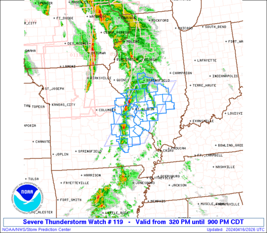
WW 119 SEVERE TSTM IL MO 162020Z - 170200Z
URGENT - IMMEDIATE BROADCAST REQUESTED
Severe Thunderstorm Watch Number 119
NWS Storm Prediction Center Norman OK
320 PM CDT Tue Apr 16 2024

The NWS Storm Prediction Center has issued a

* Severe Thunderstorm Watch for portions of
  Southern Illinois
  Southeast Missouri

* Effective this Tuesday afternoon and evening from 320 PM until
  900 PM CDT.

* Primary threats include...
  Scattered damaging wind gusts to 65 mph possible
  Scattered large hail events to 1.5 inches in diameter possible
  A tornado or two possible

SUMMARY...Strong to severe storms will continue to move
east-northeastward across the region this afternoon, with damaging
winds and hail as the primary risks.

The severe thunderstorm watch area is approximately along and 55
statute miles east and west of a line from 45 miles west northwest
of Mattoon IL to 40 miles southwest of Farmington MO. For a complete
depiction of the watch see the associated watch outline update
(WOUS64 KWNS WOU9).

PRECAUTIONARY/PREPAREDNESS ACTIONS...

REMEMBER...A Severe Thunderstorm Watch means conditions are
favorable for severe thunderstorms in and close to the watch area.
Persons in these areas should be on the lookout for threatening
weather conditions and listen for later statements and possible
warnings. Severe thunderstorms can and occasionally do produce
tornadoes.

&&

OTHER WATCH INFORMATION...CONTINUE...WW 116...WW 117...WW 118...

AVIATION...A few severe thunderstorms with hail surface and aloft to
1.5 inches. Extreme turbulence and surface wind gusts to 55 knots. A
few cumulonimbi with maximum tops to 500. Mean storm motion vector
24035.

...Guyer
Read more -
WW 0119 Status Updates
STATUS REPORT ON WW 119

THE SEVERE WEATHER THREAT CONTINUES ACROSS THE ENTIRE WATCH AREA.

..KERR..04/16/24

ATTN...WFO...LSX...ILX...


STATUS REPORT FOR WS 119

SEVERE WEATHER THREAT CONTINUES FOR THE FOLLOWING AREAS

ILC005-013-021-025-027-049-051-061-083-117-119-121-129-133-135-
157-163-167-173-189-162240-

IL
.    ILLINOIS COUNTIES INCLUDED ARE

BOND                 CALHOUN             CHRISTIAN
CLAY                 CLINTON             EFFINGHAM
FAYETTE              GREENE              JERSEY
MACOUPIN             MADISON             MARION
MENARD               MONROE              MONTGOMERY
RANDOLPH             ST. CLAIR           SANGAMON
SHELBY               WASHINGTON


MOC055-071-093-099-113-123-179-183-186-187-189-219-221-510-
162240-

MO
.    MISSOURI COUNTIES INCLUDED ARE

CRAWFORD             FRANKLIN            IRON
JEFFERSON            LINCOLN             MADISON
REYNOLDS             ST. CHARLES         STE. GENEVIEVE
ST. FRANCOIS         ST. LOUIS           WARREN
WASHINGTON
Read more -
WW 119 SEVERE TSTM IL MO 162020Z - 170200Z
URGENT - IMMEDIATE BROADCAST REQUESTED
Severe Thunderstorm Watch Number 119
NWS Storm Prediction Center Norman OK
320 PM CDT Tue Apr 16 2024

The NWS Storm Prediction Center has issued a

* Severe Thunderstorm Watch for portions of
  Southern Illinois
  Southeast Missouri

* Effective this Tuesday afternoon and evening from 320 PM until
  900 PM CDT.

* Primary threats include...
  Scattered damaging wind gusts to 65 mph possible
  Scattered large hail events to 1.5 inches in diameter possible
  A tornado or two possible

SUMMARY...Strong to severe storms will continue to move
east-northeastward across the region this afternoon, with damaging
winds and hail as the primary risks.

The severe thunderstorm watch area is approximately along and 55
statute miles east and west of a line from 45 miles west northwest
of Mattoon IL to 40 miles southwest of Farmington MO. For a complete
depiction of the watch see the associated watch outline update
(WOUS64 KWNS WOU9).

PRECAUTIONARY/PREPAREDNESS ACTIONS...

REMEMBER...A Severe Thunderstorm Watch means conditions are
favorable for severe thunderstorms in and close to the watch area.
Persons in these areas should be on the lookout for threatening
weather conditions and listen for later statements and possible
warnings. Severe thunderstorms can and occasionally do produce
tornadoes.

&&

OTHER WATCH INFORMATION...CONTINUE...WW 116...WW 117...WW 118...

AVIATION...A few severe thunderstorms with hail surface and aloft to
1.5 inches. Extreme turbulence and surface wind gusts to 55 knots. A
few cumulonimbi with maximum tops to 500. Mean storm motion vector
24035.

...Guyer
Read more -
WW 0118 Status Updates
STATUS REPORT ON WW 118

SEVERE WEATHER THREAT CONTINUES RIGHT OF A LINE FROM 25 W DSM TO
40 NW DSM TO 20 WSW FOD TO 35 WSW SPW TO 10 WNW FSD.

..BENTLEY..04/16/24

ATTN...WFO...DMX...FSD...OAX...


STATUS REPORT FOR WT 118

SEVERE WEATHER THREAT CONTINUES FOR THE FOLLOWING AREAS

IAC021-041-059-063-081-091-109-119-141-143-147-151-167-187-189-
195-162140-

IA
.    IOWA COUNTIES INCLUDED ARE

BUENA VISTA          CLAY                DICKINSON
EMMET                HANCOCK             HUMBOLDT
KOSSUTH              LYON                O'BRIEN
OSCEOLA              PALO ALTO           POCAHONTAS
SIOUX                WEBSTER             WINNEBAGO
WORTH


THE WATCH STATUS MESSAGE IS FOR GUIDANCE PURPOSES ONLY.  PLEASE
REFER TO WATCH COUNTY NOTIFICATION STATEMENTS FOR OFFICIAL
INFORMATION ON COUNTIES...INDEPENDENT CITIES AND MARINE ZONES
CLEARED FROM SEVERE THUNDERSTORM AND TORNADO WATCHES.
Read more -
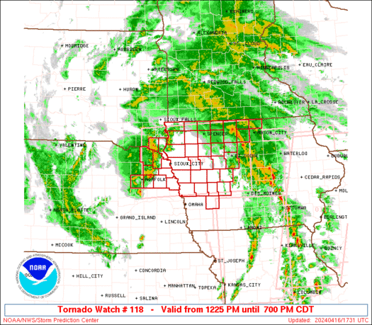
WW 118 TORNADO IA NE SD 161725Z - 170000Z
URGENT - IMMEDIATE BROADCAST REQUESTED
Tornado Watch Number 118
NWS Storm Prediction Center Norman OK
1225 PM CDT Tue Apr 16 2024

The NWS Storm Prediction Center has issued a

* Tornado Watch for portions of
  Western and Northern Iowa
  Northeast Nebraska
  Southeast South Dakota

* Effective this Tuesday afternoon and evening from 1225 PM until
  700 PM CDT.

* Primary threats include...
  A couple tornadoes possible
  Scattered large hail events to 1.5 inches in diameter possible
  Isolated damaging wind gusts to 60 mph possible

SUMMARY...A tornado/hail risk will exist through the afternoon as
far west as northeast Nebraska and southeast South Dakota near a
surface low, with other severe storms expected to develop into
additional parts of Iowa.

The tornado watch area is approximately along and 65 statute miles
north and south of a line from 30 miles north of Norfolk NE to 35
miles east of Fort Dodge IA. For a complete depiction of the watch
see the associated watch outline update (WOUS64 KWNS WOU8).

PRECAUTIONARY/PREPAREDNESS ACTIONS...

REMEMBER...A Tornado Watch means conditions are favorable for
tornadoes and severe thunderstorms in and close to the watch
area. Persons in these areas should be on the lookout for
threatening weather conditions and listen for later statements
and possible warnings.

&&

OTHER WATCH INFORMATION...CONTINUE...WW 116...WW 117...

AVIATION...Tornadoes and a few severe thunderstorms with hail
surface and aloft to 1.5 inches. Extreme turbulence and surface wind
gusts to 50 knots. A few cumulonimbi with maximum tops to 450. Mean
storm motion vector 22035.

...Guyer
Read more


SPC Day 1 Fire Weather Outlook
in Storm Prediction Center RSS Feed
Posted
View the full article