


NorthGeorgiaWX
-
Posts
34,615 -
Joined
-
Last visited
-
Days Won
1,501
Content Type
Profiles
Blogs
Forums
Gallery
Events
Store
Downloads
Posts posted by NorthGeorgiaWX
-
-
SPC 0600Z Day 2 Outlook

Day 2 Convective Outlook
NWS Storm Prediction Center Norman OK
1256 AM CDT Thu May 09 2024

Valid 101200Z - 111200Z

...THERE IS A SLIGHT RISK OF SEVERE THUNDERSTORMS ACROSS PARTS OF
NORTH FLORIDA...SOUTH GEORGIA...AND COASTAL SOUTH CAROLINA...

...SUMMARY...
Isolated to scattered severe thunderstorms appear possible Friday
across parts of the Southeast. Damaging winds should be the main
threat.

...Southeast...
A compact but intense bow/MCS may be ongoing Friday morning across
parts of south GA into north FL. The location of this bow, its
intensity, and potential longevity to the Atlantic Coast remain
rather uncertain at this time. Still, a moist and unstable airmass
should be present across the Southeast Friday morning, along and
south of a cold front. A convectively augmented mid-level vorticity
maximum should accompany the small bow across the central Gulf Coast
vicinity. This feature and attendant enhanced mid-level westerly
winds should provide sufficient deep-layer shear for continued
organization of the bow as it moves quickly eastward Friday morning
across the remainder of north FL/south GA, and eventually off the
Atlantic Coast. Severe/damaging winds will likely be the main
concern with this MCS, although an embedded tornado or two also
appears possible. Have included a Slight Risk where damaging winds
appear most likely with the morning convection. However, a faster
progression than currently forecast may require further adjustments
to the corridor of greatest severe threat.

In the wake of this morning activity, additional convective
development and evolution across the Southeast remains unclear.
Robust thunderstorms could regenerate across parts of north FL on
the outflow of the morning MCS, with both a hail and wind threat
given a favorable environment forecast. Severe probabilities have
been expanded southward some across the FL Peninsula to account for
this plausible scenario. Other isolated strong to severe convection
may develop along or just ahead of the south-southeastward moving
cold front Thursday afternoon. This seems more likely to the north
of the morning MCS across parts of the Carolinas, and perhaps
north/central GA. Occasional damaging wind gusts and hail should be
the main threats if this thunderstorms develop in this somewhat
separate regime.

...West/South-Central Texas...
A cold front should decelerate as it moves southward across TX on
Friday. Modest easterly low-level flow will impinge on the higher
terrain of northern Mexico. At this point, it appears that
large-scale ascent will remain nebulous, with a belt of modestly
enhanced westerly mid-level flow persisting. A strong thunderstorm
or two may attempt to develop either along the cold front, or across
northern Mexico in the low-level upslope flow regime. Regardless,
the threat for severe convection across west/south-central TX still
appears too uncertain/conditional for low severe probabilities at
this time.

...Upper Midwest...
A shortwave trough will dig southeastward across the Upper Midwest
Friday. Limited low-level moisture and weak instability should be in
place across this region. But, strong/gusty winds may still occur
with low-topped convection that may develop and spread quickly
southeastward as low-level lapse rates steepen with daytime heating.
The potential for severe winds currently appears too limited to
include any probabilities.

..Gleason.. 05/09/2024
Read more -
SPC 1200Z Day 1 Outlook
Day 1 Convective Outlook
NWS Storm Prediction Center Norman OK
0100 AM CDT Thu May 09 2024

Valid 091200Z - 101200Z

...THERE IS AN ENHANCED RISK OF SEVERE THUNDERSTORMS FROM
CENTRAL/NORTH TX EASTWARD ACROSS THE SOUTHEAST INTO SOUTHERN SC...

...SUMMARY...
Very large hail with multiple supercells appears probable across
parts of central Texas into the ArkLaTex vicinity Thursday afternoon
and evening. A broader corridor of severe hail and damaging-wind
potential will extend from east Texas into the lower Mississippi
Valley and Southeast.

...Synopsis...
Another very active severe weather episode is possible later today,
with the main threat expected along a generally west-to-east
corridor from parts of north/central TX into the Southeast. Some
severe potential will persist across parts of AL/GA during the day,
with at least some risk of all severe hazards. Supercells capable of
producing very large to giant hail and possibly a couple of
tornadoes are possible across parts of central/north TX during the
afternoon and early evening. One or more fast-moving MCSs may move
eastward across parts of the Southeast tonight, potentially
producing a swath of damaging wind.

A large, positively tilted upper-level trough will cover much of the
CONUS on Thursday. An embedded mid/upper-level low will move slowly
and perhaps retrograde toward the eastern Great Basin, with moderate
to strong westerly midlevel flow extending eastward across the
southern Plains and Southeast. A cold front will move across parts
of the southern Plains and Southeast through the day, with the
frontal position potentially influenced by widespread antecedent
convection that will likely last into the morning.

...MS/AL/GA/SC during the day...
A cluster of strong to potentially severe storms may be ongoing
across parts of MS/AL/GA/SC at the start of the forecast period.
This convection may expand in coverage through the morning within
broad low-level warm advection, and generally spread
east-southeastward toward the coast. Downstream of this convection,
diurnal heating of a very moist airmass will support moderate to
potentially strong buoyancy, while favorable deep-layer shear will
continue to support organized convection. A mixture of supercells
and bowing segments will be possible, with an attendant threat of
damaging gusts, hail, and possibly a few tornadoes.

...Parts of central/north TX during the afternoon...
There is some signal for isolated storm development this morning
across western portion of the Edwards Plateau, on the western fringe
of deeper low-level moisture and strong instability. Any storm that
matures in this area could quickly evolve into a supercell with a
threat of very large hail and localized severe gusts.

If any early development persists northeastward, or else does not
disrupt the warm sector, then a supercell threat is expected to
evolve into parts of central/north TX during the afternoon, both
near the dryline/front intersection and also potentially to the cool
side of the front. Strong to extreme instability (with MLCAPE across
the warm sector potentially in the 3000-4000 J/kg range), favorable
deep-layer shear, and elongated/straight hodographs will support a
threat of very large to giant hail. Low-level flow/shear will be
rather weak, but some tornado threat could also evolve, especially
where storm and/or boundary interactions take place.

...Central/north TX eastward across the Southeast during the
evening/overnight...
A majority of HREF guidance and also some larger-scale guidance
(such as the NAM/GFS/ECMWF) depict potential for development of a
fast-moving MCS that would move from parts of central/north TX
across the Southeast into the overnight hours. The pattern generally
favors this scenario, with favorable downstream moisture/instability
and moderate to strong westerly flow aloft. If this scenario pans
out, then a long swath of damaging winds will be possible from TX
across much of the Southeast, including the potential for gusts of
greater than 75 mph, and possibly brief line-embedded tornadoes.
However, given the inherent uncertainty with late-period MCS
development, combined with uncertainty regarding the evolution of
diurnal convection into MS/AL/GA, no increase in unconditional wind
probabilities has been made with this outlook. The 30% wind area has
been expanded southward, based on the latest guidance.

...North Carolina into the Mid Atlantic and Ohio Valley...
Some early convection may persist into parts of NC and the Mid
Atlantic, with a threat of isolated damaging wind. Some
redevelopment will be possible into parts of IN/OH, where weak to
moderate buoyancy may persist in advance of a cold front. Deep-layer
shear will remain sufficient for organized convection, and a few
stronger cells/clusters capable of isolated hail and damaging wind
will be possible.

..Dean/Wendt.. 05/09/2024
Read more -
SPC Day 2 Fire Weather Outlook
Day 2 Fire Weather Outlook
NWS Storm Prediction Center Norman OK
1242 AM CDT Thu May 09 2024

Valid 101200Z - 111200Z

...NO CRITICAL AREAS...

...Synopsis...
A closed low in the Great Basin will remain nearly stationary on
Friday, though upper-level winds will weaken during the day. High
pressure and cooler air will continue to be pushed against the
central/southern Rockies. Some dry and breezy conditions are
possible in the Southwest. However, the spatial extent and duration
of these conditions should be less than on Thursday. Only localized
fire weather concerns are anticipated.

..Wendt.. 05/09/2024

...Please see www.spc.noaa.gov/fire for graphic product...
Read more -
SPC Day 1 Fire Weather Outlook
Day 1 Fire Weather Outlook
NWS Storm Prediction Center Norman OK
1239 AM CDT Thu May 09 2024

Valid 091200Z - 101200Z

...NO CRITICAL AREAS...

...Synopsis...
The elongated upper trough will evolve into a closed low over the
Great Basin today. Farther east, the primary upper trough will move
into parts of the Southeast and Mid-Atlantic. At the surface, a cold
front will push south into the Southern Plains and cooler air will
push up against the southern Rockies.

Fire weather concerns are expected to remain low for most areas.
Some dry and breezy conditions are possible in the Southwest. Winds
outside of terrain-favored areas will reach 15-20 mph with RH
falling to 10-20%. Fuels in Arizona still do not support a large
fire threat. Fuels into New Mexico are drier, but the duration of
any elevated conditions appears too limited to support highlights.

..Wendt.. 05/09/2024

...Please see www.spc.noaa.gov/fire for graphic product...
Read more -
Severe Thunderstorm Warning issued May 8 at 11:41PM EDT until May 9 at 12:15AM EDT by NWS Peachtree City GA
-
MD 0719 CONCERNING TORNADO WATCH 208...210... FOR ARKLATEX VICINITY
Mesoscale Discussion 0719
NWS Storm Prediction Center Norman OK
0930 PM CDT Wed May 08 2024

Areas affected...ArkLaTex Vicinity

Concerning...Tornado Watch 208...210...

Valid 090230Z - 090430Z

The severe weather threat for Tornado Watch 208, 210 continues.

SUMMARY...The risk of large/very-large hail, isolated severe gusts,
and a tornado or two could persist beyond 03Z. Watch extensions
could be needed for southeast Arkansas into northwest Louisiana.

DISCUSSION...Two supercells continue east-southeastward in northeast
Texas. They have both shown some oscillations in intensity  and
organization over the past hour or so. The environment remains
strongly buoyant ahead of them with 40-50 kts of effective shear.
Large to possibly very large hail still may occur as could isolated
severe gusts. The tornado risk is less certain, though a modest
increase in low-level helicity is evident downstream on objective
mesoanalysis. Based on current projections, these storms will
probably effect portions of northwest Louisiana and southeast
Arkansas beyond the 03Z time frame when WW 208 and WW 210 are set to
expire. Some local extensions in time/area may be needed to account
for this possibility.

..Wendt.. 05/09/2024

...Please see www.spc.noaa.gov for graphic product...

ATTN...WFO...SHV...FWD...

LAT...LON   32539620 32769660 32879654 33079625 34089490 33479325
            32859306 32099447 32429582 32539620
Read more -
MD 0720 CONCERNING SEVERE POTENTIAL...WATCH POSSIBLE FOR FAR WESTERN NORTH CAROLINA...NORTHWESTERN SOUTH CAROLINA...AND NORTHEASTERN GEORGIA
Mesoscale Discussion 0720
NWS Storm Prediction Center Norman OK
0931 PM CDT Wed May 08 2024

Areas affected...far western North Carolina...northwestern South
Carolina...and northeastern Georgia

Concerning...Severe potential...Watch possible

Valid 090231Z - 090400Z

Probability of Watch Issuance...60 percent

SUMMARY...Severe/supercell storms moving across southern
Appalachians will begin to spread east of WW 211 in the next hour.
New WW may be required.

DISCUSSION...Latest radar shows strong/severe storms -- including
embedded supercells -- moving eastward across eastern Tennessee,
northern Alabama, and northwestern Georgia.  Hints of upscale growth
into banded structures is indicated within the overall area of
widespread convection, with likelihood that convection will continue
over the next few hours.

As such, storms will begin spreading out of WW 211 over the next
hour or so.  The downstream airmass in lee of the Appalachians is
less unstable, particularly from northeastern Tennessee into
northern and central North Carolina.  Convection moving into
northeastern Tennessee has shown a gradual weakening trend,
confirming the less-favorable airmass.

However, across far southwestern North Carolina and northwestern
South Carolina, and into northeastern Georgia, a more favorably
unstable airmass exists.  This would appear to be the most likely
area for continued severe-weather potential in the next 2 to 4
hours.  This threat -- which would include locally damaging winds,
marginal hail, and possibly a tornado or two -- may require new WW
issuance.

..Goss/Hart.. 05/09/2024

...Please see www.spc.noaa.gov for graphic product...

ATTN...WFO...CAE...GSP...MRX...FFC...

LAT...LON   35678317 35308231 34418203 33968236 34148309 34558369
            35348396 35678317
Read more -
MD 0721 CONCERNING TORNADO WATCH 212... FOR SOUTHEASTERN MISSOURI...SOUTHERN ILLINOIS...AND WESTERN KENTUCKY
Mesoscale Discussion 0721
NWS Storm Prediction Center Norman OK
1034 PM CDT Wed May 08 2024

Areas affected...southeastern Missouri...southern Illinois...and
western Kentucky

Concerning...Tornado Watch 212...

Valid 090334Z - 090500Z

The severe weather threat for Tornado Watch 212 continues.

SUMMARY...Risk for damaging winds and hail, and a couple of
tornadoes, continues across the discussion area (within Tornado
Watch 212).

DISCUSSION...A bowing band of storms is moving out of southeastern
Missouri into southern Illinois at this time, while more
isolated/rotating cells continue to gradually increase in coverage
from the Missouri Bootheel into western Kentucky.  With this area on
the northern fringe of a moderately unstable airmass, storms will
likely maintain intensity over the next couple of hours.  Aided by
veering low-level flow that increase to 50-plus kt above 4km AGL,
shear will support updraft rotation.  Resulting, all-hazards severe
risk will therefore likely continue through midnight, spreading
gradually eastward with time, toward eastern portions of the watch.

..Goss.. 05/09/2024

...Please see www.spc.noaa.gov for graphic product...

ATTN...WFO...LMK...OHX...PAH...MEG...LZK...

LAT...LON   36329120 36819087 37438989 37928945 37868884 37028704
            36548743 36329120
Read more -
Special Weather Statement issued May 8 at 11:31PM EDT by NWS Peachtree City GA
-
Severe Thunderstorm Warning issued May 8 at 11:16PM EDT until May 9 at 12:00AM EDT by NWS Peachtree City GA
-
Tornado Watch issued May 8 at 11:12PM EDT until May 9 at 4:00AM EDT by NWS Greenville-Spartanburg SC
-
Tornado Watch issued May 8 at 11:12PM EDT until May 9 at 4:00AM EDT by NWS Peachtree City GA
-
Tornado Watch issued May 8 at 11:12PM EDT until May 9 at 4:00AM EDT by NWS Peachtree City GA
-
Severe Thunderstorm Warning issued May 8 at 11:11PM EDT until May 9 at 12:15AM EDT by NWS Peachtree City GA
-
-
-
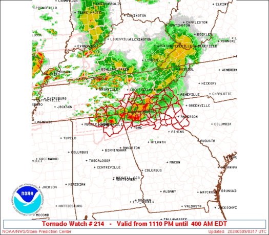
WW 214 TORNADO AL GA NC SC TN 090310Z - 090800Z
URGENT - IMMEDIATE BROADCAST REQUESTED
Tornado Watch Number 214
NWS Storm Prediction Center Norman OK
1110 PM EDT Wed May 8 2024

The NWS Storm Prediction Center has issued a

* Tornado Watch for portions of
  Northeast Alabama
  Northern Georgia
  Southwest North Carolina
  Western South Carolina
  Southeast Tennessee

* Effective this Wednesday night and Thursday morning from 1110
  PM until 400 AM EDT.

* Primary threats include...
  A few tornadoes likely with a couple intense tornadoes possible
  Scattered large hail and isolated very large hail events to 2
    inches in diameter likely
  Scattered damaging wind gusts to 70 mph likely

SUMMARY...Numerous severe thunderstorms continue from northern
Alabama into northern Georgia and southeast Tennessee.  These storms
will track eastward overnight across the watch area, while new
isolated storms develop and move in from the west.  Damaging winds
and tornadoes are possible with these storms.

The tornado watch area is approximately along and 40 statute miles
north and south of a line from 85 miles west southwest of
Chattanooga TN to 20 miles south of Asheville NC. For a complete
depiction of the watch see the associated watch outline update
(WOUS64 KWNS WOU4).

PRECAUTIONARY/PREPAREDNESS ACTIONS...

REMEMBER...A Tornado Watch means conditions are favorable for
tornadoes and severe thunderstorms in and close to the watch
area. Persons in these areas should be on the lookout for
threatening weather conditions and listen for later statements
and possible warnings.

&&

OTHER WATCH INFORMATION...CONTINUE...WW 211...WW 212...WW 213...

AVIATION...Tornadoes and a few severe thunderstorms with hail
surface and aloft to 2 inches. Extreme turbulence and surface wind
gusts to 60 knots. A few cumulonimbi with maximum tops to 500. Mean
storm motion vector 27030.

...Hart
Read more -
Flash Flood Warning issued May 8 at 11:01PM EDT until May 9 at 5:00AM EDT by NWS Peachtree City GA
-
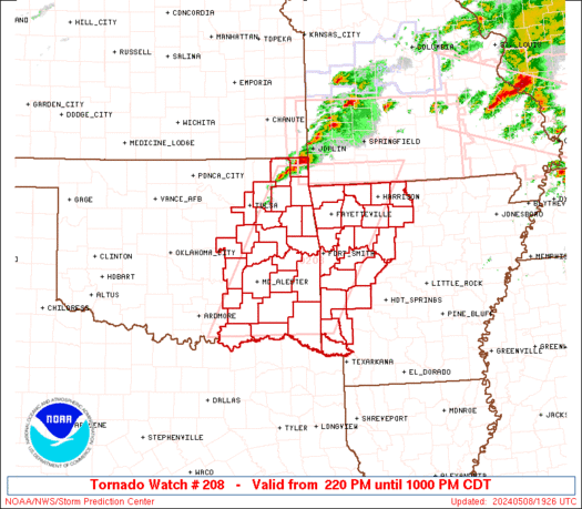
WW 0208 Status Updates
STATUS REPORT ON WW 208

SEVERE WEATHER THREAT CONTINUES RIGHT OF A LINE FROM 30 WSW DEQ
TO 10 WNW DEQ TO 25 NW RKR TO 15 SSW FYV TO 5 SSW HRO TO 15 NNW
FLP.

FOR ADDITIONAL INFORMATION SEE MESOSCALE DISCUSSION 0719

..WENDT..05/09/24

ATTN...WFO...TSA...LZK...SHV...OUN...


STATUS REPORT FOR WT 208

SEVERE WEATHER THREAT CONTINUES FOR THE FOLLOWING AREAS

ARC033-047-061-071-081-087-089-101-129-131-133-090340-

AR
.    ARKANSAS COUNTIES INCLUDED ARE

CRAWFORD             FRANKLIN            HOWARD
JOHNSON              LITTLE RIVER        MADISON
MARION               NEWTON              SEARCY
SEBASTIAN            SEVIER


OKC079-135-090340-

OK
.    OKLAHOMA COUNTIES INCLUDED ARE

LE FLORE             SEQUOYAH


THE WATCH STATUS MESSAGE IS FOR GUIDANCE PURPOSES ONLY.  PLEASE
REFER TO WATCH COUNTY NOTIFICATION STATEMENTS FOR OFFICIAL
INFORMATION ON COUNTIES...INDEPENDENT CITIES AND MARINE ZONES
Read more -
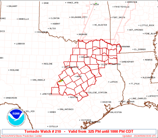
WW 0210 Status Updates
STATUS REPORT ON WW 210

SEVERE WEATHER THREAT CONTINUES RIGHT OF A LINE FROM 25 SSE TYR
TO 30 SE DAL TO 15 ESE DAL TO 15 SSW PRX TO 30 NE PRX.

FOR ADDITIONAL INFORMATION SEE MESOSCALE DISCUSSION 0719

..WENDT..05/09/24

ATTN...WFO...SHV...FWD...HGX...EWX...


STATUS REPORT FOR WT 210

SEVERE WEATHER THREAT CONTINUES FOR THE FOLLOWING AREAS

ARC091-090340-

AR
.    ARKANSAS COUNTIES INCLUDED ARE

MILLER


TXC037-063-067-119-159-183-203-223-231-257-315-343-379-387-397-
423-449-459-467-499-090340-

TX
.    TEXAS COUNTIES INCLUDED ARE

BOWIE                CAMP                CASS
DELTA                FRANKLIN            GREGG
HARRISON             HOPKINS             HUNT
KAUFMAN              MARION              MORRIS
RAINS                RED RIVER           ROCKWALL
SMITH                TITUS               UPSHUR
VAN ZANDT            WOOD
Read more -
WW 0210 Status Updates
STATUS REPORT ON WW 210

SEVERE WEATHER THREAT CONTINUES RIGHT OF A LINE FROM 25 SSE TYR
TO 30 SE DAL TO 15 ESE DAL TO 15 SSW PRX TO 30 NE PRX.

FOR ADDITIONAL INFORMATION SEE MESOSCALE DISCUSSION 0719

..WENDT..05/09/24

ATTN...WFO...SHV...FWD...HGX...EWX...


STATUS REPORT FOR WT 210

SEVERE WEATHER THREAT CONTINUES FOR THE FOLLOWING AREAS

ARC091-090340-

AR
.    ARKANSAS COUNTIES INCLUDED ARE

MILLER


TXC037-063-067-119-159-183-203-223-231-257-315-343-379-387-397-
423-449-459-467-499-090340-

TX
.    TEXAS COUNTIES INCLUDED ARE

BOWIE                CAMP                CASS
DELTA                FRANKLIN            GREGG
HARRISON             HOPKINS             HUNT
KAUFMAN              MARION              MORRIS
RAINS                RED RIVER           ROCKWALL
SMITH                TITUS               UPSHUR
VAN ZANDT            WOOD
Read more


GA - Flash Flood Warning issued May 9 at 2:42AM EDT until May 9 at 8:45AM EDT by NWS Peachtree City GA
in Georgia Weather Alerts RSS Feed
Posted
View the full article