


NorthGeorgiaWX
-
Posts
34,615 -
Joined
-
Last visited
-
Days Won
1,501
Content Type
Profiles
Blogs
Forums
Gallery
Events
Store
Downloads
Posts posted by NorthGeorgiaWX
-
-
WW 0212 Status Updates

STATUS REPORT ON WW 212

SEVERE WEATHER THREAT CONTINUES RIGHT OF A LINE FROM 5 S UMN TO
15 SE SGF TO 30 SW TBN TO 20 SSE JEF.

..BENTLEY..05/08/24

ATTN...WFO...PAH...LSX...SGF...


STATUS REPORT FOR WT 212

SEVERE WEATHER THREAT CONTINUES FOR THE FOLLOWING AREAS

ILC003-055-059-069-077-087-127-133-145-151-153-157-165-181-199-
090040-

IL
.    ILLINOIS COUNTIES INCLUDED ARE

ALEXANDER            FRANKLIN            GALLATIN
HARDIN               JACKSON             JOHNSON
MASSAC               MONROE              PERRY
POPE                 PULASKI             RANDOLPH
SALINE               UNION               WILLIAMSON


KYC007-033-035-039-047-055-075-083-105-107-139-143-145-157-177-
219-221-225-233-090040-

KY
.    KENTUCKY COUNTIES INCLUDED ARE

BALLARD              CALDWELL            CALLOWAY
CARLISLE             CHRISTIAN           CRITTENDEN
FULTON               GRAVES              HICKMAN
HOPKINS              LIVINGSTON          LYON
MCCRACKEN            MARSHALL            MUHLENBERG
TODD                 TRIGG               UNION
Read more -
SPC Day 3-8 Fire Weather Outlook
Day 3-8 Fire Weather Outlook
NWS Storm Prediction Center Norman OK
0444 PM CDT Wed May 08 2024

Valid 101200Z - 161200Z

Building surface high pressure will overspread the central/southern
Plains through much of the extended, keeping winds light and
limiting fire weather concerns where fuels are the driest.

Continued upper-level troughing over the western US and weak lee
troughing across the High Plains and will maintain areas of
dry/breezy conditions across eastern AZ/southwest NM. This may
support localized areas of Elevated fire weather concerns D3/Friday
and D4/Saturday. Rain chances are forecast to increase D3/Friday
across the Four Corners/southern High Plains, which should aid in
limiting fire potential in those regions.

As the western trough ejects into the Southern Plains D4/Saturday
into D5/Sunday, Critical conditions may return to far western
Texas/southern New Mexico. Potential for precipitation across this
region lowers confidence in including any areas with this outlook.

..Thornton.. 05/08/2024

...Please see www.spc.noaa.gov/fire for graphic product...
Read more -
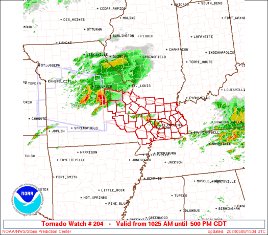
WW 0204 Status Updates
STATUS REPORT ON WW 204

SEVERE WEATHER THREAT CONTINUES RIGHT OF A LINE FROM 25 SSE TBN
TO 15 WNW FAM TO 25 S BLV TO 20 E BLV.

..BENTLEY..05/09/24

ATTN...WFO...PAH...LSX...


STATUS REPORT FOR WT 204

SEVERE WEATHER THREAT CONTINUES FOR THE FOLLOWING AREAS

ILC003-055-059-069-077-087-127-145-151-153-157-165-181-199-
090140-

IL
.    ILLINOIS COUNTIES INCLUDED ARE

ALEXANDER            FRANKLIN            GALLATIN
HARDIN               JACKSON             JOHNSON
MASSAC               PERRY               POPE
PULASKI              RANDOLPH            SALINE
UNION                WILLIAMSON


KYC007-033-035-039-055-075-083-105-139-143-145-157-221-090140-

KY
.    KENTUCKY COUNTIES INCLUDED ARE

BALLARD              CALDWELL            CALLOWAY
CARLISLE             CRITTENDEN          FULTON
GRAVES               HICKMAN             LIVINGSTON
LYON                 MCCRACKEN           MARSHALL
TRIGG
Read more -
WW 0204 Status Updates
STATUS REPORT ON WW 204

THE SEVERE WEATHER THREAT CONTINUES ACROSS THE ENTIRE WATCH AREA.

..BENTLEY..05/08/24

ATTN...WFO...PAH...LSX...


STATUS REPORT FOR WT 204

SEVERE WEATHER THREAT CONTINUES FOR THE FOLLOWING AREAS

ILC003-055-059-069-077-087-127-133-145-151-153-157-165-181-199-
082240-

IL
.    ILLINOIS COUNTIES INCLUDED ARE

ALEXANDER            FRANKLIN            GALLATIN
HARDIN               JACKSON             JOHNSON
MASSAC               MONROE              PERRY
POPE                 PULASKI             RANDOLPH
SALINE               UNION               WILLIAMSON


KYC007-033-035-039-055-075-083-105-139-143-145-157-221-082240-

KY
.    KENTUCKY COUNTIES INCLUDED ARE

BALLARD              CALDWELL            CALLOWAY
CARLISLE             CRITTENDEN          FULTON
GRAVES               HICKMAN             LIVINGSTON
LYON                 MCCRACKEN           MARSHALL
TRIGG


MOC017-031-055-071-073-093-099-123-133-143-157-179-186-187-201-
Read more -
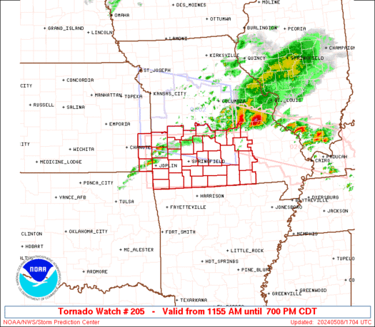
WW 0205 Status Updates
STATUS REPORT ON WW 205

SEVERE WEATHER THREAT CONTINUES RIGHT OF A LINE FROM 30 WNW JLN
TO 45 N JLN TO 40 SSE OJC.

..BENTLEY..05/08/24

ATTN...WFO...SGF...


STATUS REPORT FOR WT 205

SEVERE WEATHER THREAT CONTINUES FOR THE FOLLOWING AREAS

KSC021-082240-

KS
.    KANSAS COUNTIES INCLUDED ARE

CHEROKEE


MOC009-011-029-039-043-057-059-065-067-077-085-091-097-105-109-
119-145-149-153-161-167-169-185-203-209-213-215-217-225-229-
082240-

MO
.    MISSOURI COUNTIES INCLUDED ARE

BARRY                BARTON              CAMDEN
CEDAR                CHRISTIAN           DADE
DALLAS               DENT                DOUGLAS
GREENE               HICKORY             HOWELL
JASPER               LACLEDE             LAWRENCE
MCDONALD             NEWTON              OREGON
OZARK                PHELPS              POLK
PULASKI              ST. CLAIR           SHANNON
STONE                TANEY               TEXAS
VERNON               WEBSTER             WRIGHT
Read more -
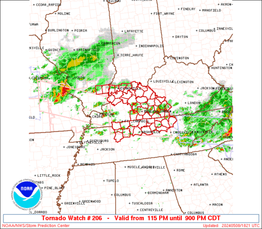
WW 0206 Status Updates
STATUS REPORT ON WW 206

THE SEVERE WEATHER THREAT CONTINUES ACROSS THE ENTIRE WATCH AREA.

..BENTLEY..05/08/24

ATTN...WFO...PAH...LMK...OHX...


STATUS REPORT FOR WT 206

SEVERE WEATHER THREAT CONTINUES FOR THE FOLLOWING AREAS

ILC065-193-082240-

IL
.    ILLINOIS COUNTIES INCLUDED ARE

HAMILTON             WHITE


INC123-129-147-163-173-082240-

IN
.    INDIANA COUNTIES INCLUDED ARE

PERRY                POSEY               SPENCER
VANDERBURGH          WARRICK


KYC001-003-009-027-031-053-057-059-061-085-087-091-093-099-101-
123-141-149-163-169-171-183-207-213-217-225-227-233-082240-

KY
.    KENTUCKY COUNTIES INCLUDED ARE

ADAIR                ALLEN               BARREN
BRECKINRIDGE         BUTLER              CLINTON
CUMBERLAND           DAVIESS             EDMONSON
Read more -
-
-
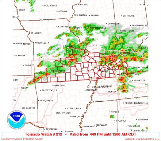
WW 212 TORNADO IL KY MO 082140Z - 090500Z
URGENT - IMMEDIATE BROADCAST REQUESTED
Tornado Watch Number 212
NWS Storm Prediction Center Norman OK
440 PM CDT Wed May 8 2024

The NWS Storm Prediction Center has issued a

* Tornado Watch for portions of
  Southern Illinois
  Western Kentucky
  Southern Missouri

* Effective this Wednesday afternoon from 440 PM until Midnight
  CDT.

* Primary threats include...
  A few tornadoes and a couple intense tornadoes likely
  Widespread large hail and scattered very large hail events to
    2.5 inches in diameter likely
  Widespread damaging winds and isolated significant gusts to 75
    mph likely

SUMMARY...Multiple rounds of severe thunderstorms will affect the
watch area through the afternoon and evening, posing a risk of large
hail and damaging winds.  A few tornadoes are also expected.

The tornado watch area is approximately along and 50 statute miles
north and south of a line from 20 miles west of Springfield MO to 40
miles north northeast of Fort Campbell KY. For a complete depiction
of the watch see the associated watch outline update (WOUS64 KWNS
WOU2).

PRECAUTIONARY/PREPAREDNESS ACTIONS...

REMEMBER...A Tornado Watch means conditions are favorable for
tornadoes and severe thunderstorms in and close to the watch
area. Persons in these areas should be on the lookout for
threatening weather conditions and listen for later statements
and possible warnings.

&&

OTHER WATCH INFORMATION...CONTINUE...WW 204...WW 205...WW
206...WW 207...WW 208...WW 209...WW 210...WW 211...

AVIATION...Tornadoes and a few severe thunderstorms with hail
surface and aloft to 2.5 inches. Extreme turbulence and surface wind
gusts to 65 knots. A few cumulonimbi with maximum tops to 500. Mean
storm motion vector 26035.

...Hart
Read more -
WW 0207 Status Updates
STATUS REPORT ON WW 207

SEVERE WEATHER THREAT CONTINUES RIGHT OF A LINE FROM 30 ESE SPA
TO 25 S CLT TO 20 ESE CLT TO 30 SW GSO.

..BENTLEY..05/08/24

ATTN...WFO...RAH...ILM...GSP...MHX...CAE...


STATUS REPORT FOR WS 207

SEVERE WEATHER THREAT CONTINUES FOR THE FOLLOWING AREAS

NCC007-017-025-051-061-085-093-105-123-125-153-155-159-163-165-
167-179-082240-

NC
.    NORTH CAROLINA COUNTIES INCLUDED ARE

ANSON                BLADEN              CABARRUS
CUMBERLAND           DUPLIN              HARNETT
HOKE                 LEE                 MONTGOMERY
MOORE                RICHMOND            ROBESON
ROWAN                SAMPSON             SCOTLAND
STANLY               UNION


SCC023-025-031-033-039-041-055-057-059-061-067-069-071-087-
082240-

SC
.    SOUTH CAROLINA COUNTIES INCLUDED ARE

CHESTER              CHESTERFIELD        DARLINGTON
DILLON               FAIRFIELD           FLORENCE
KERSHAW              LANCASTER           LAURENS
LEE                  MARION              MARLBORO
NEWBERRY             UNION
Read more -
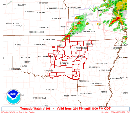
WW 0208 Status Updates
STATUS REPORT ON WW 208

THE SEVERE WEATHER THREAT CONTINUES ACROSS THE ENTIRE WATCH AREA.

..BENTLEY..05/08/24

ATTN...WFO...TSA...LZK...SHV...OUN...


STATUS REPORT FOR WT 208

SEVERE WEATHER THREAT CONTINUES FOR THE FOLLOWING AREAS

ARC007-009-015-033-047-061-071-081-083-087-089-097-101-113-115-
127-129-131-133-143-149-082240-

AR
.    ARKANSAS COUNTIES INCLUDED ARE

BENTON               BOONE               CARROLL
CRAWFORD             FRANKLIN            HOWARD
JOHNSON              LITTLE RIVER        LOGAN
MADISON              MARION              MONTGOMERY
NEWTON               POLK                POPE
SCOTT                SEARCY              SEBASTIAN
SEVIER               WASHINGTON          YELL


OKC001-005-013-021-023-029-035-041-061-063-077-079-089-091-097-
101-107-111-115-121-127-131-135-143-145-082240-

OK
.    OKLAHOMA COUNTIES INCLUDED ARE

ADAIR                ATOKA               BRYAN
CHEROKEE             CHOCTAW             COAL
CRAIG                DELAWARE            HASKELL
HUGHES               LATIMER             LE FLORE
MCCURTAIN            MCINTOSH            MAYES
Read more -
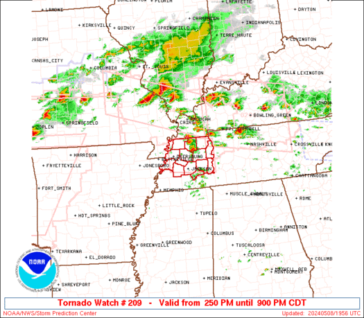
WW 0209 Status Updates
STATUS REPORT ON WW 209

THE SEVERE WEATHER THREAT CONTINUES ACROSS THE ENTIRE WATCH AREA.

..BENTLEY..05/08/24

ATTN...WFO...MEG...


STATUS REPORT FOR WT 209

SEVERE WEATHER THREAT CONTINUES FOR THE FOLLOWING AREAS

TNC005-017-023-033-039-045-053-075-077-079-095-097-113-131-183-
082240-

TN
.    TENNESSEE COUNTIES INCLUDED ARE

BENTON               CARROLL             CHESTER
CROCKETT             DECATUR             DYER
GIBSON               HAYWOOD             HENDERSON
HENRY                LAKE                LAUDERDALE
MADISON              OBION               WEAKLEY


THE WATCH STATUS MESSAGE IS FOR GUIDANCE PURPOSES ONLY.  PLEASE
REFER TO WATCH COUNTY NOTIFICATION STATEMENTS FOR OFFICIAL
INFORMATION ON COUNTIES...INDEPENDENT CITIES AND MARINE ZONES
CLEARED FROM SEVERE THUNDERSTORM AND TORNADO WATCHES.
Read more -
WW 0210 Status Updates
STATUS REPORT ON WW 210

THE SEVERE WEATHER THREAT CONTINUES ACROSS THE ENTIRE WATCH AREA.

..BENTLEY..05/08/24

ATTN...WFO...SHV...FWD...HGX...EWX...


STATUS REPORT FOR WT 210

SEVERE WEATHER THREAT CONTINUES FOR THE FOLLOWING AREAS

ARC091-082240-

AR
.    ARKANSAS COUNTIES INCLUDED ARE

MILLER


TXC001-027-035-037-051-053-063-067-085-099-113-119-121-139-145-
147-159-161-181-183-193-203-213-217-221-223-231-251-257-277-281-
287-289-293-299-309-315-331-343-349-379-387-395-397-423-425-439-
449-459-467-491-499-082240-

TX
.    TEXAS COUNTIES INCLUDED ARE

ANDERSON             BELL                BOSQUE
BOWIE                BURLESON            BURNET
CAMP                 CASS                COLLIN
CORYELL              DALLAS              DELTA
DENTON               ELLIS               FALLS
FANNIN               FRANKLIN            FREESTONE
GRAYSON              GREGG               HAMILTON
HARRISON             HENDERSON           HILL
HOOD                 HOPKINS             HUNT
JOHNSON              KAUFMAN             LAMAR
Read more -
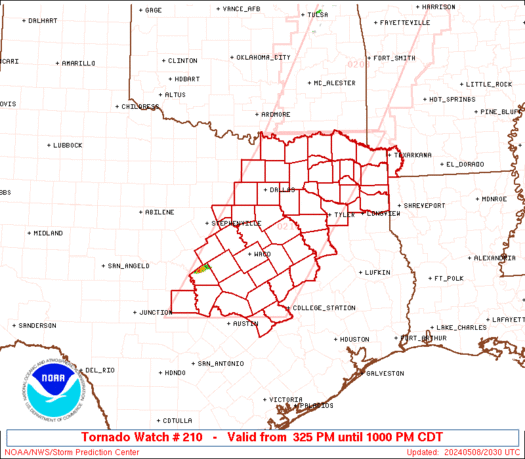
WW 210 TORNADO AR TX 082025Z - 090300Z
URGENT - IMMEDIATE BROADCAST REQUESTED
Tornado Watch Number 210
NWS Storm Prediction Center Norman OK
325 PM CDT Wed May 8 2024

The NWS Storm Prediction Center has issued a

* Tornado Watch for portions of
  Southwest Arkansas
  Central and North and Northeast Texas

* Effective this Wednesday afternoon and evening from 325 PM
  until 1000 PM CDT.

* Primary threats include...
  A couple tornadoes possible
  Scattered large hail and isolated very large hail events to 4
    inches in diameter likely
  Scattered damaging wind gusts to 70 mph likely

SUMMARY...Isolated supercells are forecast to develop southward
along the dryline in north and central Texas this afternoon.  A very
moist and extremely unstable airmass will be favorable for giant
hail with the more intense updrafts.  The risk for a tornado may
maximize with any mature supercell that can locally augment
low-level shear later this afternoon into the evening.  A cluster of
severe storms may develop towards evening over northeast Texas and
pose a risk for all severe hazards.

The tornado watch area is approximately along and 80 statute miles
east and west of a line from 20 miles north of Paris TX to 55 miles
south southwest of Temple TX. For a complete depiction of the watch
see the associated watch outline update (WOUS64 KWNS WOU0).

PRECAUTIONARY/PREPAREDNESS ACTIONS...

REMEMBER...A Tornado Watch means conditions are favorable for
tornadoes and severe thunderstorms in and close to the watch
area. Persons in these areas should be on the lookout for
threatening weather conditions and listen for later statements
and possible warnings.

&&

OTHER WATCH INFORMATION...CONTINUE...WW 204...WW 205...WW
206...WW 207...WW 208...WW 209...

AVIATION...Tornadoes and a few severe thunderstorms with hail
surface and aloft to 4 inches. Extreme turbulence and surface wind
gusts to 60 knots. A few cumulonimbi with maximum tops to 500. Mean
storm motion vector 24025.

...Smith
Read more


SPC Tornado Watch 212 Status Reports
in Storm Prediction Center RSS Feed
Posted
View the full article