


NorthGeorgiaWX
-
Posts
34,615 -
Joined
-
Last visited
-
Days Won
1,501
Content Type
Profiles
Blogs
Forums
Gallery
Events
Store
Downloads
Posts posted by NorthGeorgiaWX
-
-
Severe Thunderstorm Warning issued May 8 at 9:54PM EDT until May 8 at 10:30PM EDT by NWS Peachtree City GA
-
SPC 0100Z Day 1 Outlook

Day 1 Convective Outlook CORR 1 NWS Storm Prediction Center Norman OK 0842 PM CDT Wed May 08 2024 Valid 090100Z - 091200Z ...THERE IS A MODERATE RISK OF SEVERE THUNDERSTORMS FROM SOUTHEAST MO INTO WESTERN KY...WESTERN/MIDDLE TN...NORTHERN AL...FAR NORTHWEST GA... CORRECTED FOR WIND GRAPHIC ...SUMMARY... Severe thunderstorms remain likely this evening from parts of the mid Mississippi, Ohio, and Tennessee Valleys into the southern Plains. All severe hazards, including tornadoes, very large hail, and potentially significant damaging winds are possible. Some tornadoes may be strong, especially this evening from far northern Alabama into southeast Tennessee. ...Ozarks into the TN Valley and Carolinas... Numerous strong to severe storms are ongoing this evening from the Ozark region east-southeastward through the TN Valley and Carolinas. Convection has largely remained semi-discrete thus far, but a gradual transition to more of a linear or cluster mode (still with embedded supercells) will be possible tonight. Very large hail and tornadoes (possibly strong) will continue to be a threat with any persistent supercells, with some increase in the damaging wind threat possible if organized upscale growth occurs. Some severe threat may spread eastward across areas of eastern TN into the Carolinas that were affected by earlier severe storms. With intense storms ongoing across southern MO and recent HRRR runs depicting bow echo development across southeast MO, a portion of the Moderate Risk has been maintained. Parts of the Enhanced and Moderate Risks have also been expanded southeastward, with regenerative supercell development possible this evening from southern middle and southeast TN into far northern AL. A small 15% tornado area has been added in this area as well, due to the potential for tornadic supercells into mid/late evening. ...ArkLaTex vicinity into central TX... Isolated storms have developed along/ahead of a front from eastern OK into north-central/northeast TX. Extreme instability and strong deep-layer shear will support a threat of very large hail with any sustained supercell, along with a risk for localized severe gusts. The extreme instability and primarily supercell mode will also support some tornado threat, even though low-level flow/shear is generally modest across the region. Storm coverage and intensity should diminish by late evening into the overnight, as MLCINH gradually increases. ..Dean.. 05/09/2024
Read more -
WW 0212 Status Updates
STATUS REPORT ON WW 212 SEVERE WEATHER THREAT CONTINUES RIGHT OF A LINE FROM 10 N HRO TO 35 N FLP TO 20 NNW UNO TO 45 NNE UNO TO 35 WSW FAM TO 25 NE FAM. ..BENTLEY..05/09/24 ATTN...WFO...PAH...LSX...SGF... STATUS REPORT FOR WT 212 SEVERE WEATHER THREAT CONTINUES FOR THE FOLLOWING AREAS ILC003-047-059-065-069-077-087-127-151-153-165-181-185-193-199- 090240- IL . ILLINOIS COUNTIES INCLUDED ARE ALEXANDER EDWARDS GALLATIN HAMILTON HARDIN JACKSON JOHNSON MASSAC POPE PULASKI SALINE UNION WABASH WHITE WILLIAMSON INC051-125-129-147-163-173-090240- IN . INDIANA COUNTIES INCLUDED ARE GIBSON PIKE POSEY SPENCER VANDERBURGH WARRICK KYC007-033-035-039-047-055-059-075-083-101-105-107-139-143-145- 149-157-177-219-221-225-233-090240-
Read more -
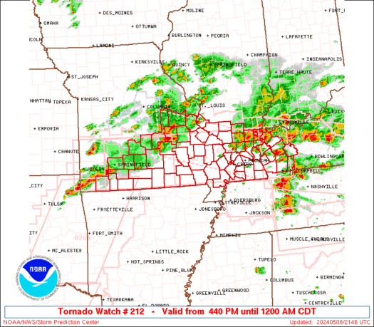
WW 212 TORNADO IL KY MO 082140Z - 090500Z
URGENT - IMMEDIATE BROADCAST REQUESTED Tornado Watch Number 212 NWS Storm Prediction Center Norman OK 440 PM CDT Wed May 8 2024 The NWS Storm Prediction Center has issued a * Tornado Watch for portions of Southern Illinois Western Kentucky Southern Missouri * Effective this Wednesday afternoon from 440 PM until Midnight CDT. * Primary threats include... A few tornadoes and a couple intense tornadoes likely Widespread large hail and scattered very large hail events to 2.5 inches in diameter likely Widespread damaging winds and isolated significant gusts to 75 mph likely SUMMARY...Multiple rounds of severe thunderstorms will affect the watch area through the afternoon and evening, posing a risk of large hail and damaging winds. A few tornadoes are also expected. The tornado watch area is approximately along and 50 statute miles north and south of a line from 20 miles west of Springfield MO to 40 miles north northeast of Fort Campbell KY. For a complete depiction of the watch see the associated watch outline update (WOUS64 KWNS WOU2). PRECAUTIONARY/PREPAREDNESS ACTIONS... REMEMBER...A Tornado Watch means conditions are favorable for tornadoes and severe thunderstorms in and close to the watch area. Persons in these areas should be on the lookout for threatening weather conditions and listen for later statements and possible warnings. && OTHER WATCH INFORMATION...CONTINUE...WW 204...WW 205...WW 206...WW 207...WW 208...WW 209...WW 210...WW 211... AVIATION...Tornadoes and a few severe thunderstorms with hail surface and aloft to 2.5 inches. Extreme turbulence and surface wind gusts to 65 knots. A few cumulonimbi with maximum tops to 500. Mean storm motion vector 26035. ...HartRead more -
WW 0212 Status Updates
STATUS REPORT ON WW 212 SEVERE WEATHER THREAT CONTINUES RIGHT OF A LINE FROM 10 N HRO TO 35 N FLP TO 20 NNW UNO TO 45 NNE UNO TO 35 WSW FAM TO 25 NE FAM. ..BENTLEY..05/09/24 ATTN...WFO...PAH...LSX...SGF... STATUS REPORT FOR WT 212 SEVERE WEATHER THREAT CONTINUES FOR THE FOLLOWING AREAS ILC003-047-059-065-069-077-087-127-151-153-165-181-185-193-199- 090240- IL . ILLINOIS COUNTIES INCLUDED ARE ALEXANDER EDWARDS GALLATIN HAMILTON HARDIN JACKSON JOHNSON MASSAC POPE PULASKI SALINE UNION WABASH WHITE WILLIAMSON INC051-125-129-147-163-173-090240- IN . INDIANA COUNTIES INCLUDED ARE GIBSON PIKE POSEY SPENCER VANDERBURGH WARRICK KYC007-033-035-039-047-055-059-075-083-101-105-107-139-143-145- 149-157-177-219-221-225-233-090240-
Read more -
WW 212 TORNADO IL KY MO 082140Z - 090500Z
URGENT - IMMEDIATE BROADCAST REQUESTED Tornado Watch Number 212 NWS Storm Prediction Center Norman OK 440 PM CDT Wed May 8 2024 The NWS Storm Prediction Center has issued a * Tornado Watch for portions of Southern Illinois Western Kentucky Southern Missouri * Effective this Wednesday afternoon from 440 PM until Midnight CDT. * Primary threats include... A few tornadoes and a couple intense tornadoes likely Widespread large hail and scattered very large hail events to 2.5 inches in diameter likely Widespread damaging winds and isolated significant gusts to 75 mph likely SUMMARY...Multiple rounds of severe thunderstorms will affect the watch area through the afternoon and evening, posing a risk of large hail and damaging winds. A few tornadoes are also expected. The tornado watch area is approximately along and 50 statute miles north and south of a line from 20 miles west of Springfield MO to 40 miles north northeast of Fort Campbell KY. For a complete depiction of the watch see the associated watch outline update (WOUS64 KWNS WOU2). PRECAUTIONARY/PREPAREDNESS ACTIONS... REMEMBER...A Tornado Watch means conditions are favorable for tornadoes and severe thunderstorms in and close to the watch area. Persons in these areas should be on the lookout for threatening weather conditions and listen for later statements and possible warnings. && OTHER WATCH INFORMATION...CONTINUE...WW 204...WW 205...WW 206...WW 207...WW 208...WW 209...WW 210...WW 211... AVIATION...Tornadoes and a few severe thunderstorms with hail surface and aloft to 2.5 inches. Extreme turbulence and surface wind gusts to 65 knots. A few cumulonimbi with maximum tops to 500. Mean storm motion vector 26035. ...HartRead more -
WW 0213 Status Updates
STATUS REPORT ON WW 213 THE SEVERE WEATHER THREAT CONTINUES ACROSS THE ENTIRE WATCH AREA. ..BENTLEY..05/09/24 ATTN...WFO...LZK...MEG...OHX... STATUS REPORT FOR WT 213 SEVERE WEATHER THREAT CONTINUES FOR THE FOLLOWING AREAS ARC001-005-019-021-023-029-031-035-037-045-049-051-053-055-059- 063-065-067-069-075-077-083-085-093-095-097-105-107-109-111-113- 115-117-119-121-123-125-127-135-137-141-145-147-149-090240- AR . ARKANSAS COUNTIES INCLUDED ARE ARKANSAS BAXTER CLARK CLAY CLEBURNE CONWAY CRAIGHEAD CRITTENDEN CROSS FAULKNER FULTON GARLAND GRANT GREENE HOT SPRING INDEPENDENCE IZARD JACKSON JEFFERSON LAWRENCE LEE LOGAN LONOKE MISSISSIPPI MONROE MONTGOMERY PERRY PHILLIPS PIKE POINSETT POLK POPE PRAIRIE PULASKI RANDOLPH ST. FRANCIS SALINE SCOTT SHARP STONE VAN BUREN WHITE WOODRUFF YELL MSC033-143-090240-
Read more -
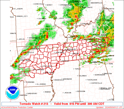
WW 213 TORNADO AR MO MS TN 090115Z - 090800Z
URGENT - IMMEDIATE BROADCAST REQUESTED Tornado Watch Number 213 NWS Storm Prediction Center Norman OK 815 PM CDT Wed May 8 2024 The NWS Storm Prediction Center has issued a * Tornado Watch for portions of Central and Northern Arkansas Missouri Bootheel Northwest Mississippi Western and Middle Tennessee * Effective this Wednesday night and Thursday morning from 815 PM until 300 AM CDT. * Primary threats include... A few tornadoes likely with a couple intense tornadoes possible Widespread large hail and scattered very large hail events to 3 inches in diameter likely Widespread damaging winds and isolated significant gusts to 80 mph likely SUMMARY...Multiple rounds of severe thunderstorms will continue to occur across the watch area into the overnight period. Supercells and bowing storms capable of damaging winds, large hail, and tornadoes will be possible. The tornado watch area is approximately along and 55 statute miles north and south of a line from 50 miles west of Russellville AR to 10 miles north northeast of Crossville TN. For a complete depiction of the watch see the associated watch outline update (WOUS64 KWNS WOU3). PRECAUTIONARY/PREPAREDNESS ACTIONS... REMEMBER...A Tornado Watch means conditions are favorable for tornadoes and severe thunderstorms in and close to the watch area. Persons in these areas should be on the lookout for threatening weather conditions and listen for later statements and possible warnings. && OTHER WATCH INFORMATION...CONTINUE...WW 206...WW 208...WW 209...WW 210...WW 211...WW 212... AVIATION...Tornadoes and a few severe thunderstorms with hail surface and aloft to 3 inches. Extreme turbulence and surface wind gusts to 70 knots. A few cumulonimbi with maximum tops to 500. Mean storm motion vector 27035. ...HartRead more -
WW 0213 Status Updates
STATUS REPORT ON WW 213 THE SEVERE WEATHER THREAT CONTINUES ACROSS THE ENTIRE WATCH AREA. ..BENTLEY..05/09/24 ATTN...WFO...LZK...MEG...OHX... STATUS REPORT FOR WT 213 SEVERE WEATHER THREAT CONTINUES FOR THE FOLLOWING AREAS ARC001-005-019-021-023-029-031-035-037-045-049-051-053-055-059- 063-065-067-069-075-077-083-085-093-095-097-105-107-109-111-113- 115-117-119-121-123-125-127-135-137-141-145-147-149-090240- AR . ARKANSAS COUNTIES INCLUDED ARE ARKANSAS BAXTER CLARK CLAY CLEBURNE CONWAY CRAIGHEAD CRITTENDEN CROSS FAULKNER FULTON GARLAND GRANT GREENE HOT SPRING INDEPENDENCE IZARD JACKSON JEFFERSON LAWRENCE LEE LOGAN LONOKE MISSISSIPPI MONROE MONTGOMERY PERRY PHILLIPS PIKE POINSETT POLK POPE PRAIRIE PULASKI RANDOLPH ST. FRANCIS SALINE SCOTT SHARP STONE VAN BUREN WHITE WOODRUFF YELL MSC033-143-090240-
Read more -
WW 213 TORNADO AR MO MS TN 090115Z - 090800Z
URGENT - IMMEDIATE BROADCAST REQUESTED Tornado Watch Number 213 NWS Storm Prediction Center Norman OK 815 PM CDT Wed May 8 2024 The NWS Storm Prediction Center has issued a * Tornado Watch for portions of Central and Northern Arkansas Missouri Bootheel Northwest Mississippi Western and Middle Tennessee * Effective this Wednesday night and Thursday morning from 815 PM until 300 AM CDT. * Primary threats include... A few tornadoes likely with a couple intense tornadoes possible Widespread large hail and scattered very large hail events to 3 inches in diameter likely Widespread damaging winds and isolated significant gusts to 80 mph likely SUMMARY...Multiple rounds of severe thunderstorms will continue to occur across the watch area into the overnight period. Supercells and bowing storms capable of damaging winds, large hail, and tornadoes will be possible. The tornado watch area is approximately along and 55 statute miles north and south of a line from 50 miles west of Russellville AR to 10 miles north northeast of Crossville TN. For a complete depiction of the watch see the associated watch outline update (WOUS64 KWNS WOU3). PRECAUTIONARY/PREPAREDNESS ACTIONS... REMEMBER...A Tornado Watch means conditions are favorable for tornadoes and severe thunderstorms in and close to the watch area. Persons in these areas should be on the lookout for threatening weather conditions and listen for later statements and possible warnings. && OTHER WATCH INFORMATION...CONTINUE...WW 206...WW 208...WW 209...WW 210...WW 211...WW 212... AVIATION...Tornadoes and a few severe thunderstorms with hail surface and aloft to 3 inches. Extreme turbulence and surface wind gusts to 70 knots. A few cumulonimbi with maximum tops to 500. Mean storm motion vector 27035. ...HartRead more -
WW 0211 Status Updates
STATUS REPORT ON WW 211 THE SEVERE WEATHER THREAT CONTINUES ACROSS THE ENTIRE WATCH AREA. ..BENTLEY..05/09/24 ATTN...WFO...HUN...FFC...MRX... STATUS REPORT FOR WT 211 SEVERE WEATHER THREAT CONTINUES FOR THE FOLLOWING AREAS ALC033-043-049-059-071-077-079-083-089-095-103-090240- AL . ALABAMA COUNTIES INCLUDED ARE COLBERT CULLMAN DEKALB FRANKLIN JACKSON LAUDERDALE LAWRENCE LIMESTONE MADISON MARSHALL MORGAN GAC047-055-083-085-111-123-129-187-213-227-281-291-295-311-313- 090240- GA . GEORGIA COUNTIES INCLUDED ARE CATOOSA CHATTOOGA DADE DAWSON FANNIN GILMER GORDON LUMPKIN MURRAY PICKENS TOWNS UNION WALKER WHITE WHITFIELD NCC039-043-090240-
Read more -
WW 211 TORNADO AL GA NC TN 082115Z - 090400Z
URGENT - IMMEDIATE BROADCAST REQUESTED Tornado Watch Number 211 NWS Storm Prediction Center Norman OK 515 PM EDT Wed May 8 2024 The NWS Storm Prediction Center has issued a * Tornado Watch for portions of Northern Alabama Northern Georgia Far western North Carolina Eastern Tennessee * Effective this Wednesday afternoon from 515 PM until Midnight EDT. * Primary threats include... A couple tornadoes possible Scattered large hail likely with isolated very large hail events to 2 inches in diameter possible Scattered damaging wind gusts to 70 mph likely SUMMARY...A few supercells will be possible this evening along a remnant outflow boundary, where a couple of tornadoes will be possible. Otherwise, additional storms could spread into this area later this evening with an accompanying threat for damaging winds up to 70 mph and large hail up to 2 inches in diameter. The tornado watch area is approximately along and 40 statute miles north and south of a line from 25 miles northwest of Muscle Shoals AL to 75 miles east of Chattanooga TN. For a complete depiction of the watch see the associated watch outline update (WOUS64 KWNS WOU1). PRECAUTIONARY/PREPAREDNESS ACTIONS... REMEMBER...A Tornado Watch means conditions are favorable for tornadoes and severe thunderstorms in and close to the watch area. Persons in these areas should be on the lookout for threatening weather conditions and listen for later statements and possible warnings. && OTHER WATCH INFORMATION...CONTINUE...WW 204...WW 205...WW 206...WW 207...WW 208...WW 209...WW 210... AVIATION...Tornadoes and a few severe thunderstorms with hail surface and aloft to 2 inches. Extreme turbulence and surface wind gusts to 60 knots. A few cumulonimbi with maximum tops to 550. Mean storm motion vector 27025. ...ThompsonRead more -
WW 0208 Status Updates
STATUS REPORT ON WW 208 SEVERE WEATHER THREAT CONTINUES RIGHT OF A LINE FROM 20 NW PRX TO 40 SE MLC TO 30 W RKR TO 25 NNW FSM TO 15 NE FYV TO 25 NNE HRO. ..BENTLEY..05/09/24 ATTN...WFO...TSA...LZK...SHV...OUN... STATUS REPORT FOR WT 208 SEVERE WEATHER THREAT CONTINUES FOR THE FOLLOWING AREAS ARC009-015-033-047-061-071-081-087-089-101-129-131-133-143- 090240- AR . ARKANSAS COUNTIES INCLUDED ARE BOONE CARROLL CRAWFORD FRANKLIN HOWARD JOHNSON LITTLE RIVER MADISON MARION NEWTON SEARCY SEBASTIAN SEVIER WASHINGTON OKC023-061-077-079-089-127-135-090240- OK . OKLAHOMA COUNTIES INCLUDED ARE CHOCTAW HASKELL LATIMER LE FLORE MCCURTAIN PUSHMATAHA SEQUOYAH THE WATCH STATUS MESSAGE IS FOR GUIDANCE PURPOSES ONLY. PLEASE REFER TO WATCH COUNTY NOTIFICATION STATEMENTS FOR OFFICIAL
Read more -
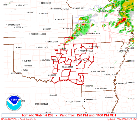
WW 208 TORNADO AR OK 081920Z - 090300Z
URGENT - IMMEDIATE BROADCAST REQUESTED Tornado Watch Number 208 NWS Storm Prediction Center Norman OK 220 PM CDT Wed May 8 2024 The NWS Storm Prediction Center has issued a * Tornado Watch for portions of Western Arkansas Eastern Oklahoma * Effective this Wednesday afternoon and evening from 220 PM until 1000 PM CDT. * Primary threats include... A few tornadoes likely with a couple intense tornadoes possible Scattered damaging winds and isolated significant gusts to 75 mph likely Scattered large hail and isolated very large hail events to 4 inches in diameter likely SUMMARY...Scattered supercells are forecast to develop across eastern Oklahoma late this afternoon and move into western Arkansas late this afternoon into the evening. Giant hail is possible with the more intense supercells, in addition to the risk for a strong tornado. The tornado watch area is approximately along and 75 statute miles east and west of a line from Monett MO to 50 miles east of Durant OK. For a complete depiction of the watch see the associated watch outline update (WOUS64 KWNS WOU8). PRECAUTIONARY/PREPAREDNESS ACTIONS... REMEMBER...A Tornado Watch means conditions are favorable for tornadoes and severe thunderstorms in and close to the watch area. Persons in these areas should be on the lookout for threatening weather conditions and listen for later statements and possible warnings. && OTHER WATCH INFORMATION...CONTINUE...WW 203...WW 204...WW 205...WW 206...WW 207... AVIATION...Tornadoes and a few severe thunderstorms with hail surface and aloft to 4 inches. Extreme turbulence and surface wind gusts to 65 knots. A few cumulonimbi with maximum tops to 500. Mean storm motion vector 25030. ...SmithRead more -
WW 0210 Status Updates
STATUS REPORT ON WW 210 SEVERE WEATHER THREAT CONTINUES RIGHT OF A LINE FROM 50 S TYR TO 30 NW CRS TO 20 SSW DAL TO 10 NW DAL TO 40 NNW PRX. ..BENTLEY..05/09/24 ATTN...WFO...SHV...FWD...HGX...EWX... STATUS REPORT FOR WT 210 SEVERE WEATHER THREAT CONTINUES FOR THE FOLLOWING AREAS ARC091-090240- AR . ARKANSAS COUNTIES INCLUDED ARE MILLER TXC001-037-063-067-085-119-147-159-183-203-213-223-231-257-277- 315-343-379-387-397-423-449-459-467-499-090240- TX . TEXAS COUNTIES INCLUDED ARE ANDERSON BOWIE CAMP CASS COLLIN DELTA FANNIN FRANKLIN GREGG HARRISON HENDERSON HOPKINS HUNT KAUFMAN LAMAR MARION MORRIS RAINS RED RIVER ROCKWALL SMITH TITUS UPSHUR VAN ZANDT WOOD
Read more -
WW 210 TORNADO AR TX 082025Z - 090300Z
URGENT - IMMEDIATE BROADCAST REQUESTED
Tornado Watch Number 210
NWS Storm Prediction Center Norman OK
325 PM CDT Wed May 8 2024

The NWS Storm Prediction Center has issued a

* Tornado Watch for portions of
  Southwest Arkansas
  Central and North and Northeast Texas

* Effective this Wednesday afternoon and evening from 325 PM
  until 1000 PM CDT.

* Primary threats include...
  A couple tornadoes possible
  Scattered large hail and isolated very large hail events to 4
    inches in diameter likely
  Scattered damaging wind gusts to 70 mph likely

SUMMARY...Isolated supercells are forecast to develop southward
along the dryline in north and central Texas this afternoon.  A very
moist and extremely unstable airmass will be favorable for giant
hail with the more intense updrafts.  The risk for a tornado may
maximize with any mature supercell that can locally augment
low-level shear later this afternoon into the evening.  A cluster of
severe storms may develop towards evening over northeast Texas and
pose a risk for all severe hazards.

The tornado watch area is approximately along and 80 statute miles
east and west of a line from 20 miles north of Paris TX to 55 miles
south southwest of Temple TX. For a complete depiction of the watch
see the associated watch outline update (WOUS64 KWNS WOU0).

PRECAUTIONARY/PREPAREDNESS ACTIONS...

REMEMBER...A Tornado Watch means conditions are favorable for
tornadoes and severe thunderstorms in and close to the watch
area. Persons in these areas should be on the lookout for
threatening weather conditions and listen for later statements
and possible warnings.

&&

OTHER WATCH INFORMATION...CONTINUE...WW 204...WW 205...WW
206...WW 207...WW 208...WW 209...

AVIATION...Tornadoes and a few severe thunderstorms with hail
surface and aloft to 4 inches. Extreme turbulence and surface wind
gusts to 60 knots. A few cumulonimbi with maximum tops to 500. Mean
storm motion vector 24025.

...Smith
Read more -
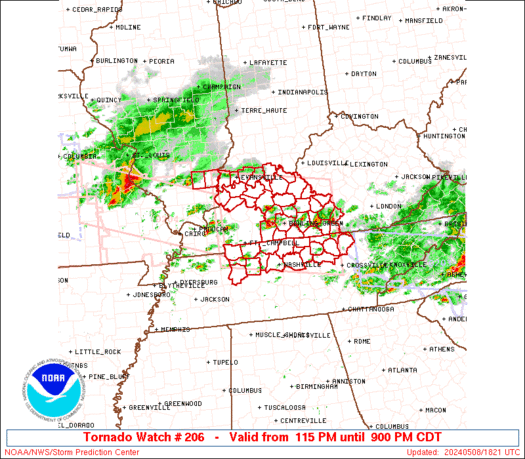
WW 0206 Status Updates
STATUS REPORT ON WW 206 THE SEVERE WEATHER THREAT CONTINUES ACROSS THE ENTIRE WATCH AREA. ..BENTLEY..05/09/24 ATTN...WFO...PAH...LMK...OHX... STATUS REPORT FOR WT 206 SEVERE WEATHER THREAT CONTINUES FOR THE FOLLOWING AREAS ILC065-193-090240- IL . ILLINOIS COUNTIES INCLUDED ARE HAMILTON WHITE INC123-129-147-163-173-090240- IN . INDIANA COUNTIES INCLUDED ARE PERRY POSEY SPENCER VANDERBURGH WARRICK KYC001-003-009-027-031-053-057-059-061-085-087-091-093-099-101- 123-141-149-163-169-171-183-207-213-217-225-227-233-090240- KY . KENTUCKY COUNTIES INCLUDED ARE ADAIR ALLEN BARREN BRECKINRIDGE BUTLER CLINTON CUMBERLAND DAVIESS EDMONSON
Read more -
WW 0206 Status Updates
STATUS REPORT ON WW 206 THE SEVERE WEATHER THREAT CONTINUES ACROSS THE ENTIRE WATCH AREA. ..BENTLEY..05/09/24 ATTN...WFO...PAH...LMK...OHX... STATUS REPORT FOR WT 206 SEVERE WEATHER THREAT CONTINUES FOR THE FOLLOWING AREAS ILC065-193-090240- IL . ILLINOIS COUNTIES INCLUDED ARE HAMILTON WHITE INC123-129-147-163-173-090240- IN . INDIANA COUNTIES INCLUDED ARE PERRY POSEY SPENCER VANDERBURGH WARRICK KYC001-003-009-027-031-053-057-059-061-085-087-091-093-099-101- 123-141-149-163-169-171-183-207-213-217-225-227-233-090240- KY . KENTUCKY COUNTIES INCLUDED ARE ADAIR ALLEN BARREN BRECKINRIDGE BUTLER CLINTON CUMBERLAND DAVIESS EDMONSON
Read more


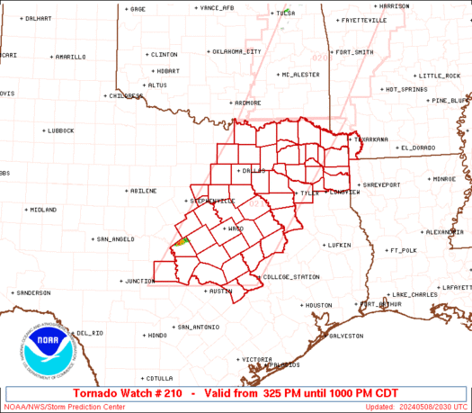
SPC Tornado Watch 210
in Storm Prediction Center RSS Feed
Posted
URGENT - IMMEDIATE BROADCAST REQUESTED
Tornado Watch Number 210
NWS Storm Prediction Center Norman OK
325 PM CDT Wed May 8 2024

The NWS Storm Prediction Center has issued a

* Tornado Watch for portions of
  Southwest Arkansas
  Central and North and Northeast Texas

* Effective this Wednesday afternoon and evening from 325 PM
  until 1000 PM CDT.

* Primary threats include...
  A couple tornadoes possible
  Scattered large hail and isolated very large hail events to 4
    inches in diameter likely
  Scattered damaging wind gusts to 70 mph likely

SUMMARY...Isolated supercells are forecast to develop southward
along the dryline in north and central Texas this afternoon.  A very
moist and extremely unstable airmass will be favorable for giant
hail with the more intense updrafts.  The risk for a tornado may
maximize with any mature supercell that can locally augment
low-level shear later this afternoon into the evening.  A cluster of
severe storms may develop towards evening over northeast Texas and
pose a risk for all severe hazards.

The tornado watch area is approximately along and 80 statute miles
east and west of a line from 20 miles north of Paris TX to 55 miles
south southwest of Temple TX. For a complete depiction of the watch
see the associated watch outline update (WOUS64 KWNS WOU0).

PRECAUTIONARY/PREPAREDNESS ACTIONS...

REMEMBER...A Tornado Watch means conditions are favorable for
tornadoes and severe thunderstorms in and close to the watch
area. Persons in these areas should be on the lookout for
threatening weather conditions and listen for later statements
and possible warnings.

&&

OTHER WATCH INFORMATION...CONTINUE...WW 204...WW 205...WW
206...WW 207...WW 208...WW 209...

AVIATION...Tornadoes and a few severe thunderstorms with hail
surface and aloft to 4 inches. Extreme turbulence and surface wind
gusts to 60 knots. A few cumulonimbi with maximum tops to 500. Mean
storm motion vector 24025.

...Smith
Read moreView the full article