


NorthGeorgiaWX
-
Posts
34,600 -
Joined
-
Last visited
-
Days Won
1,500
Content Type
Profiles
Blogs
Forums
Gallery
Events
Store
Downloads
Posts posted by NorthGeorgiaWX
-
-
WW 0207 Status Updates

STATUS REPORT ON WW 207 SEVERE WEATHER THREAT CONTINUES RIGHT OF A LINE FROM 30 ESE SPA TO 25 S CLT TO 20 ESE CLT TO 30 SW GSO. ..BENTLEY..05/08/24 ATTN...WFO...RAH...ILM...GSP...MHX...CAE... STATUS REPORT FOR WS 207 SEVERE WEATHER THREAT CONTINUES FOR THE FOLLOWING AREAS NCC007-017-025-051-061-085-093-105-123-125-153-155-159-163-165- 167-179-082240- NC . NORTH CAROLINA COUNTIES INCLUDED ARE ANSON BLADEN CABARRUS CUMBERLAND DUPLIN HARNETT HOKE LEE MONTGOMERY MOORE RICHMOND ROBESON ROWAN SAMPSON SCOTLAND STANLY UNION SCC023-025-031-033-039-041-055-057-059-061-067-069-071-087- 082240- SC . SOUTH CAROLINA COUNTIES INCLUDED ARE CHESTER CHESTERFIELD DARLINGTON DILLON FAIRFIELD FLORENCE KERSHAW LANCASTER LAURENS LEE MARION MARLBORO NEWBERRY UNION
Read more -
WW 0207 Status Updates
STATUS REPORT ON WW 207 SEVERE WEATHER THREAT CONTINUES RIGHT OF A LINE FROM 30 ESE SPA TO 25 S CLT TO 20 ESE CLT TO 30 SW GSO. ..BENTLEY..05/08/24 ATTN...WFO...RAH...ILM...GSP...MHX...CAE... STATUS REPORT FOR WS 207 SEVERE WEATHER THREAT CONTINUES FOR THE FOLLOWING AREAS NCC007-017-025-051-061-085-093-105-123-125-153-155-159-163-165- 167-179-082240- NC . NORTH CAROLINA COUNTIES INCLUDED ARE ANSON BLADEN CABARRUS CUMBERLAND DUPLIN HARNETT HOKE LEE MONTGOMERY MOORE RICHMOND ROBESON ROWAN SAMPSON SCOTLAND STANLY UNION SCC023-025-031-033-039-041-055-057-059-061-067-069-071-087- 082240- SC . SOUTH CAROLINA COUNTIES INCLUDED ARE CHESTER CHESTERFIELD DARLINGTON DILLON FAIRFIELD FLORENCE KERSHAW LANCASTER LAURENS LEE MARION MARLBORO NEWBERRY UNION
Read more -
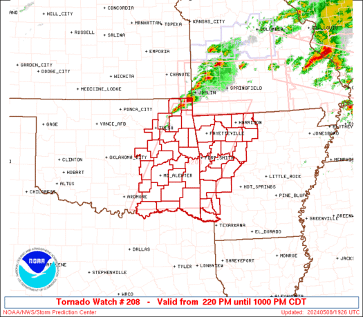
WW 0208 Status Updates
STATUS REPORT ON WW 208 THE SEVERE WEATHER THREAT CONTINUES ACROSS THE ENTIRE WATCH AREA. ..BENTLEY..05/08/24 ATTN...WFO...TSA...LZK...SHV...OUN... STATUS REPORT FOR WT 208 SEVERE WEATHER THREAT CONTINUES FOR THE FOLLOWING AREAS ARC007-009-015-033-047-061-071-081-083-087-089-097-101-113-115- 127-129-131-133-143-149-082240- AR . ARKANSAS COUNTIES INCLUDED ARE BENTON BOONE CARROLL CRAWFORD FRANKLIN HOWARD JOHNSON LITTLE RIVER LOGAN MADISON MARION MONTGOMERY NEWTON POLK POPE SCOTT SEARCY SEBASTIAN SEVIER WASHINGTON YELL OKC001-005-013-021-023-029-035-041-061-063-077-079-089-091-097- 101-107-111-115-121-127-131-135-143-145-082240- OK . OKLAHOMA COUNTIES INCLUDED ARE ADAIR ATOKA BRYAN CHEROKEE CHOCTAW COAL CRAIG DELAWARE HASKELL HUGHES LATIMER LE FLORE MCCURTAIN MCINTOSH MAYES
Read more -
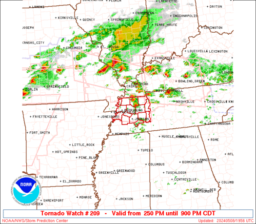
WW 0209 Status Updates
STATUS REPORT ON WW 209 THE SEVERE WEATHER THREAT CONTINUES ACROSS THE ENTIRE WATCH AREA. ..BENTLEY..05/08/24 ATTN...WFO...MEG... STATUS REPORT FOR WT 209 SEVERE WEATHER THREAT CONTINUES FOR THE FOLLOWING AREAS TNC005-017-023-033-039-045-053-075-077-079-095-097-113-131-183- 082240- TN . TENNESSEE COUNTIES INCLUDED ARE BENTON CARROLL CHESTER CROCKETT DECATUR DYER GIBSON HAYWOOD HENDERSON HENRY LAKE LAUDERDALE MADISON OBION WEAKLEY THE WATCH STATUS MESSAGE IS FOR GUIDANCE PURPOSES ONLY. PLEASE REFER TO WATCH COUNTY NOTIFICATION STATEMENTS FOR OFFICIAL INFORMATION ON COUNTIES...INDEPENDENT CITIES AND MARINE ZONES CLEARED FROM SEVERE THUNDERSTORM AND TORNADO WATCHES.
Read more -
WW 0210 Status Updates
STATUS REPORT ON WW 210 THE SEVERE WEATHER THREAT CONTINUES ACROSS THE ENTIRE WATCH AREA. ..BENTLEY..05/08/24 ATTN...WFO...SHV...FWD...HGX...EWX... STATUS REPORT FOR WT 210 SEVERE WEATHER THREAT CONTINUES FOR THE FOLLOWING AREAS ARC091-082240- AR . ARKANSAS COUNTIES INCLUDED ARE MILLER TXC001-027-035-037-051-053-063-067-085-099-113-119-121-139-145- 147-159-161-181-183-193-203-213-217-221-223-231-251-257-277-281- 287-289-293-299-309-315-331-343-349-379-387-395-397-423-425-439- 449-459-467-491-499-082240- TX . TEXAS COUNTIES INCLUDED ARE ANDERSON BELL BOSQUE BOWIE BURLESON BURNET CAMP CASS COLLIN CORYELL DALLAS DELTA DENTON ELLIS FALLS FANNIN FRANKLIN FREESTONE GRAYSON GREGG HAMILTON HARRISON HENDERSON HILL HOOD HOPKINS HUNT JOHNSON KAUFMAN LAMAR
Read more -
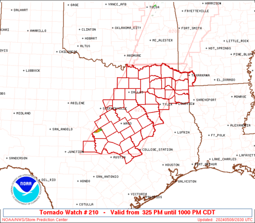
WW 210 TORNADO AR TX 082025Z - 090300Z
URGENT - IMMEDIATE BROADCAST REQUESTED Tornado Watch Number 210 NWS Storm Prediction Center Norman OK 325 PM CDT Wed May 8 2024 The NWS Storm Prediction Center has issued a * Tornado Watch for portions of Southwest Arkansas Central and North and Northeast Texas * Effective this Wednesday afternoon and evening from 325 PM until 1000 PM CDT. * Primary threats include... A couple tornadoes possible Scattered large hail and isolated very large hail events to 4 inches in diameter likely Scattered damaging wind gusts to 70 mph likely SUMMARY...Isolated supercells are forecast to develop southward along the dryline in north and central Texas this afternoon. A very moist and extremely unstable airmass will be favorable for giant hail with the more intense updrafts. The risk for a tornado may maximize with any mature supercell that can locally augment low-level shear later this afternoon into the evening. A cluster of severe storms may develop towards evening over northeast Texas and pose a risk for all severe hazards. The tornado watch area is approximately along and 80 statute miles east and west of a line from 20 miles north of Paris TX to 55 miles south southwest of Temple TX. For a complete depiction of the watch see the associated watch outline update (WOUS64 KWNS WOU0). PRECAUTIONARY/PREPAREDNESS ACTIONS... REMEMBER...A Tornado Watch means conditions are favorable for tornadoes and severe thunderstorms in and close to the watch area. Persons in these areas should be on the lookout for threatening weather conditions and listen for later statements and possible warnings. && OTHER WATCH INFORMATION...CONTINUE...WW 204...WW 205...WW 206...WW 207...WW 208...WW 209... AVIATION...Tornadoes and a few severe thunderstorms with hail surface and aloft to 4 inches. Extreme turbulence and surface wind gusts to 60 knots. A few cumulonimbi with maximum tops to 500. Mean storm motion vector 24025. ...SmithRead more -
WW 0210 Status Updates
STATUS REPORT ON WW 210 THE SEVERE WEATHER THREAT CONTINUES ACROSS THE ENTIRE WATCH AREA. ..BENTLEY..05/08/24 ATTN...WFO...SHV...FWD...HGX...EWX... STATUS REPORT FOR WT 210 SEVERE WEATHER THREAT CONTINUES FOR THE FOLLOWING AREAS ARC091-082240- AR . ARKANSAS COUNTIES INCLUDED ARE MILLER TXC001-027-035-037-051-053-063-067-085-099-113-119-121-139-145- 147-159-161-181-183-193-203-213-217-221-223-231-251-257-277-281- 287-289-293-299-309-315-331-343-349-379-387-395-397-423-425-439- 449-459-467-491-499-082240- TX . TEXAS COUNTIES INCLUDED ARE ANDERSON BELL BOSQUE BOWIE BURLESON BURNET CAMP CASS COLLIN CORYELL DALLAS DELTA DENTON ELLIS FALLS FANNIN FRANKLIN FREESTONE GRAYSON GREGG HAMILTON HARRISON HENDERSON HILL HOOD HOPKINS HUNT JOHNSON KAUFMAN LAMAR
Read more -
WW 0211 Status Updates
STATUS REPORT ON WW 211 THE SEVERE WEATHER THREAT CONTINUES ACROSS THE ENTIRE WATCH AREA. ..BENTLEY..05/08/24 ATTN...WFO...HUN...FFC...MRX... STATUS REPORT FOR WT 211 SEVERE WEATHER THREAT CONTINUES FOR THE FOLLOWING AREAS ALC033-043-049-059-071-077-079-083-089-095-103-082240- AL . ALABAMA COUNTIES INCLUDED ARE COLBERT CULLMAN DEKALB FRANKLIN JACKSON LAUDERDALE LAWRENCE LIMESTONE MADISON MARSHALL MORGAN GAC047-055-083-085-111-123-129-187-213-227-281-291-295-311-313- 082240- GA . GEORGIA COUNTIES INCLUDED ARE CATOOSA CHATTOOGA DADE DAWSON FANNIN GILMER GORDON LUMPKIN MURRAY PICKENS TOWNS UNION WALKER WHITE WHITFIELD NCC039-043-082240-
Read more -
WW 211 TORNADO AL GA NC TN 082115Z - 090400Z
URGENT - IMMEDIATE BROADCAST REQUESTED Tornado Watch Number 211 NWS Storm Prediction Center Norman OK 515 PM EDT Wed May 8 2024 The NWS Storm Prediction Center has issued a * Tornado Watch for portions of Northern Alabama Northern Georgia Far western North Carolina Eastern Tennessee * Effective this Wednesday afternoon from 515 PM until Midnight EDT. * Primary threats include... A couple tornadoes possible Scattered large hail likely with isolated very large hail events to 2 inches in diameter possible Scattered damaging wind gusts to 70 mph likely SUMMARY...A few supercells will be possible this evening along a remnant outflow boundary, where a couple of tornadoes will be possible. Otherwise, additional storms could spread into this area later this evening with an accompanying threat for damaging winds up to 70 mph and large hail up to 2 inches in diameter. The tornado watch area is approximately along and 40 statute miles north and south of a line from 25 miles northwest of Muscle Shoals AL to 75 miles east of Chattanooga TN. For a complete depiction of the watch see the associated watch outline update (WOUS64 KWNS WOU1). PRECAUTIONARY/PREPAREDNESS ACTIONS... REMEMBER...A Tornado Watch means conditions are favorable for tornadoes and severe thunderstorms in and close to the watch area. Persons in these areas should be on the lookout for threatening weather conditions and listen for later statements and possible warnings. && OTHER WATCH INFORMATION...CONTINUE...WW 204...WW 205...WW 206...WW 207...WW 208...WW 209...WW 210... AVIATION...Tornadoes and a few severe thunderstorms with hail surface and aloft to 2 inches. Extreme turbulence and surface wind gusts to 60 knots. A few cumulonimbi with maximum tops to 550. Mean storm motion vector 27025. ...ThompsonRead more -
MD 0710 CONCERNING SEVERE POTENTIAL...WATCH UNLIKELY FOR SOUTHEAST VIRGINIA
Mesoscale Discussion 0710 NWS Storm Prediction Center Norman OK 0428 PM CDT Wed May 08 2024 Areas affected...southeast Virginia Concerning...Severe potential...Watch unlikely Valid 082128Z - 082230Z Probability of Watch Issuance...5 percent SUMMARY...An isolated storm across southeast Virginia will pose a large hail and damaging wind threat through the evening. DISCUSSION...A storm has formed within an area of weak low-level confluence across south-central Virginia. The airmass ahead of this storm is very unstable with 1500 to 2500 J/kg MLCAPE. This storm appears to be mostly multi-cellular at this time which is consistent with around 25 to 30 knots of effective shear (per SPC mesoanalysis). Greater storm organization is possible as this storm cluster moves east into greater instability this evening. The environment will support both large hail and damaging wind gusts. Given the isolated nature of the threat, no watch is expected. ..Bentley/Hart.. 05/08/2024 ...Please see www.spc.noaa.gov for graphic product... ATTN...WFO...AKQ...RAH...RNK... LAT...LON 36827883 37707752 37747595 37027568 36537591 36527799 36597882 36827883Read more -
Tornado Watch issued May 8 at 5:16PM EDT until May 9 at 12:00AM EDT by NWS Peachtree City GA
-
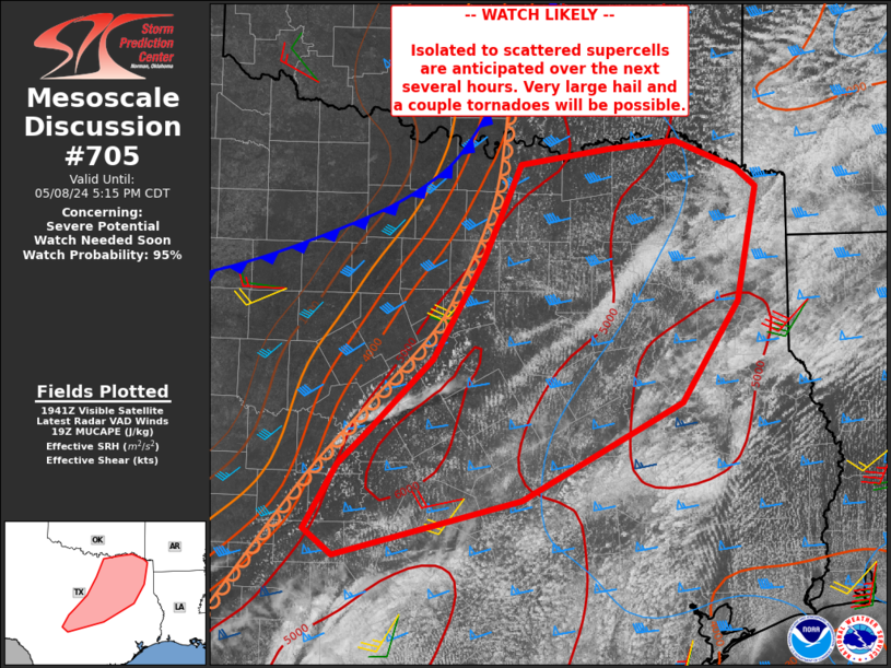
MD 0705 CONCERNING SEVERE POTENTIAL...WATCH NEEDED SOON FOR PARTS OF NORTHERN INTO CENTRAL TEXAS
Mesoscale Discussion 0705 NWS Storm Prediction Center Norman OK 0246 PM CDT Wed May 08 2024 Areas affected...parts of northern into central Texas Concerning...Severe potential...Watch needed soon Valid 081946Z - 082215Z Probability of Watch Issuance...95 percent SUMMARY...Isolated to perhaps scattered severe storms capable of very large hail and a tornado or two are expected over the next several hours from parts of central into northeast Texas. DISCUSSION...Deeper convection is beginning to form along the dryline near San Saba and Mills Counties, with increasing Cu depth extending northeastward along the dryline. A very moist and extremely unstable air mass resides east of the dryline, with MLCAPE in excess of 4000 J/kg. Effective deep-layer shear up to 50 kt with a large cross component to the boundary will favor supercell storm mode, with very large hail expected. A few tornadoes may occur as well, perhaps brief but locally intense, given extreme instability and sufficient low-level shear. An expansive, uncapped warm sector suggests cells may remain severe for a long duration. ..Jewell/Smith.. 05/08/2024 ...Please see www.spc.noaa.gov for graphic product... ATTN...WFO...SHV...HGX...FWD...OUN...EWX...SJT... LAT...LON 31569513 30709679 30209871 30439902 31019868 31289838 31949771 32819719 33669681 33799589 33869520 33629455 33469435 32449456 31569513Read more -
MD 0706 CONCERNING SEVERE THUNDERSTORM WATCH 207... FOR SOUTHERN NC AND NORTHERN SC
Mesoscale Discussion 0706 NWS Storm Prediction Center Norman OK 0258 PM CDT Wed May 08 2024 Areas affected...Southern NC and northern SC Concerning...Severe Thunderstorm Watch 207... Valid 081958Z - 082130Z The severe weather threat for Severe Thunderstorm Watch 207 continues. SUMMARY...A swath of large hail from 1-1.75 inches in diameter and damaging winds of 55-70 mph will remain likely as organized clusters across western parts of North Carolina and South Carolina progress east into this evening. DISCUSSION...An organized, outflow-dominated cluster is currently approaching Charlotte, while a separate supercell exists south of Spartanburg. Low-level shear/SRH remains quite weak in area VWP data, suggesting that this outflow-dominated evolution will persist downstream across the rest of the Piedmont towards the coastal plain. With surface temperatures peaking in the upper 80s to low 90s, MLCAPE of 2000-2500 J/kg has become common. With enhanced westerly mid/upper flow over the southern Appalachians, a continued severe hail/wind threat is expected straddling the Carolina border area for the next several hours. ..Grams.. 05/08/2024 ...Please see www.spc.noaa.gov for graphic product... ATTN...WFO...MHX...RAH...ILM...CAE...GSP... LAT...LON 35648110 35557992 35387847 35187763 35097735 34987728 34787734 34067894 34058012 34418171 34618204 34658203 35648110Read more -
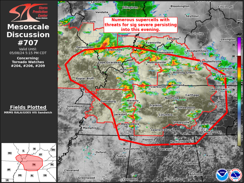
MD 0707 CONCERNING TORNADO WATCH 204...206...209... FOR MID-MS/LOWER OH AND TN VALLEYS
Mesoscale Discussion 0707 NWS Storm Prediction Center Norman OK 0341 PM CDT Wed May 08 2024 Areas affected...Mid-MS/Lower OH and TN Valleys Concerning...Tornado Watch 204...206...209... Valid 082041Z - 082215Z The severe weather threat for Tornado Watch 204, 206, 209 continues. SUMMARY...Numerous supercells are ongoing and will continue to pose threats for significant severe weather during the next several hours. Additional/expansion of tornado watches with south-southeast extent and replacement/extension of parts of WW 206 (which is scheduled to expire at 22Z) should be expected through early evening. DISCUSSION...An outbreak of supercells is underway from the Ozark Plateau across the Mid-MS and Lower OH into the TN Valleys. These storms will remain capable of producing tornadoes, large to very large hail, and damaging winds for the next several hours. Greatest tornado threat in the next few hours should be focused within three regimes. One along, the residual outflow that extends in a west/east-orientation across southern MO. The second with the long-lived supercell cluster along the tight buoyancy gradient over far southern IL into western KY. And the third area across middle TN into south-central KY, where the strongest low-level shear exists near/north of the modified convective outflow from earlier today. The southern/eastern extent of the supercell development in the TN Valley will likely necessitate additional tornado watches this evening. ..Grams.. 05/08/2024 ...Please see www.spc.noaa.gov for graphic product... ATTN...WFO...MRX...JKL...FFC...LMK...OHX...HUN...PAH...MEG... LSX... LAT...LON 37438528 36958428 35728427 34738553 34698752 34878855 35848891 36569004 36769057 37279082 37549053 37779005 37928822 37438528Read more -
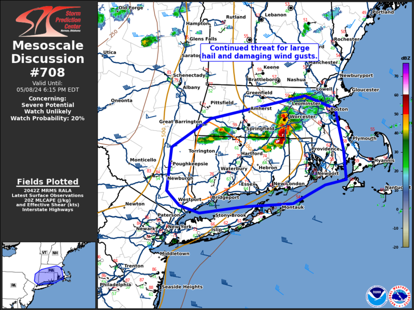
MD 0708 CONCERNING SEVERE POTENTIAL...WATCH UNLIKELY FOR SOUTHERN NEW ENGLAND
Mesoscale Discussion 0708 NWS Storm Prediction Center Norman OK 0344 PM CDT Wed May 08 2024 Areas affected...southern New England Concerning...Severe potential...Watch unlikely Valid 082044Z - 082215Z Probability of Watch Issuance...20 percent SUMMARY...The threat for large hail and damaging wind gusts continues across southern New England. DISCUSSION...A large supercell has developed in southern Massachusetts where temperatures have warmed into the mid 70s with dewpoints in the mid 60s. This has yielded 500 to 750 J/kg MLCAPE. Despite this relatively weak instability, storm organization due to 70 knots of 0-6km shear (per BOX VWP), has been sufficient for supercell maintenance. This intense storm will continue to pose a severe wind and large hail threat as it moves east and the downstream environment continues to destabilize ahead of it. In addition, some storms are starting to develop to the west of this supercell on the trailing outflow. Given a similarly warm and unstable environment, one or two more strong to severe storms may form and move along this outflow boundary this afternoon/evening. ..Bentley/Smith.. 05/08/2024 ...Please see www.spc.noaa.gov for graphic product... ATTN...WFO...BOX...OKX...ALY... LAT...LON 41887391 42287322 42597149 42417095 41847080 41447076 41387114 41127173 41087259 41007341 41097377 41297399 41887391Read more -
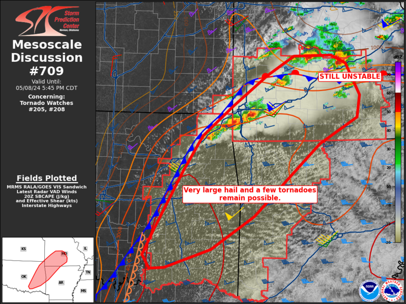
MD 0709 CONCERNING TORNADO WATCH 205...208... FOR MUCH OF SOUTHERN MISSOURI INTO EASTERN OKLAHOMA AND WESTERN ARKANSAS
Mesoscale Discussion 0709 NWS Storm Prediction Center Norman OK 0350 PM CDT Wed May 08 2024 Areas affected...much of southern Missouri into eastern Oklahoma and western Arkansas Concerning...Tornado Watch 205...208... Valid 082050Z - 082245Z The severe weather threat for Tornado Watch 205, 208 continues. SUMMARY...The threat of supercells producing very large hail, tornadoes and damaging gusts persists from southern Missouri into northeast Oklahoma, with additional storms anticipated farther south. DISCUSSION...Several supercells exist along a front from northeast OK into southwest MO, with addition activity just on the cool/north side of an east-west oriented outflow boundary from the earlier MCS. This boundary appears to be mixing out, as temperatures are recovering over south-central MO near the front. Given time of day, additional pockets of air mass recovery are possible with tornado potential remaining. Farther south, extreme instability persists over eastern OK into western AR, and convergence near the cold front in OK is expected to yield at least isolated supercells. These will have very large hail potential, along with periodic tornado threat as 0-1 SRH remains above 100 m2/s2. ..Jewell.. 05/08/2024 ...Please see www.spc.noaa.gov for graphic product... ATTN...WFO...LZK...SGF...TSA...OUN... LAT...LON 34399660 34849637 35949572 36599528 37149459 37709381 38069319 38079233 37919200 37339169 36919176 36439263 35949319 35119412 34509509 34159612 34149644 34399660Read more -
Special Weather Statement issued May 8 at 4:26PM EDT by NWS Greenville-Spartanburg SC
-
-
WW 210 TORNADO AR TX 082025Z - 090300Z
URGENT - IMMEDIATE BROADCAST REQUESTED Tornado Watch Number 210 NWS Storm Prediction Center Norman OK 325 PM CDT Wed May 8 2024 The NWS Storm Prediction Center has issued a * Tornado Watch for portions of Southwest Arkansas Central and North and Northeast Texas * Effective this Wednesday afternoon and evening from 325 PM until 1000 PM CDT. * Primary threats include... A couple tornadoes possible Scattered large hail and isolated very large hail events to 4 inches in diameter likely Scattered damaging wind gusts to 70 mph likely SUMMARY...Isolated supercells are forecast to develop southward along the dryline in north and central Texas this afternoon. A very moist and extremely unstable airmass will be favorable for giant hail with the more intense updrafts. The risk for a tornado may maximize with any mature supercell that can locally augment low-level shear later this afternoon into the evening. A cluster of severe storms may develop towards evening over northeast Texas and pose a risk for all severe hazards. The tornado watch area is approximately along and 80 statute miles east and west of a line from 20 miles north of Paris TX to 55 miles south southwest of Temple TX. For a complete depiction of the watch see the associated watch outline update (WOUS64 KWNS WOU0). PRECAUTIONARY/PREPAREDNESS ACTIONS... REMEMBER...A Tornado Watch means conditions are favorable for tornadoes and severe thunderstorms in and close to the watch area. Persons in these areas should be on the lookout for threatening weather conditions and listen for later statements and possible warnings. && OTHER WATCH INFORMATION...CONTINUE...WW 204...WW 205...WW 206...WW 207...WW 208...WW 209... AVIATION...Tornadoes and a few severe thunderstorms with hail surface and aloft to 4 inches. Extreme turbulence and surface wind gusts to 60 knots. A few cumulonimbi with maximum tops to 500. Mean storm motion vector 24025. ...SmithRead more -
WW 0204 Status Updates
STATUS REPORT ON WW 204 THE SEVERE WEATHER THREAT CONTINUES ACROSS THE ENTIRE WATCH AREA. ..BENTLEY..05/08/24 ATTN...WFO...PAH...LSX... STATUS REPORT FOR WT 204 SEVERE WEATHER THREAT CONTINUES FOR THE FOLLOWING AREAS ILC003-055-059-069-077-087-127-133-145-151-153-157-165-181-199- 082140- IL . ILLINOIS COUNTIES INCLUDED ARE ALEXANDER FRANKLIN GALLATIN HARDIN JACKSON JOHNSON MASSAC MONROE PERRY POPE PULASKI RANDOLPH SALINE UNION WILLIAMSON KYC007-033-035-039-055-075-083-105-139-143-145-157-221-082140- KY . KENTUCKY COUNTIES INCLUDED ARE BALLARD CALDWELL CALLOWAY CARLISLE CRITTENDEN FULTON GRAVES HICKMAN LIVINGSTON LYON MCCRACKEN MARSHALL TRIGG MOC017-031-055-071-073-093-099-123-133-143-157-179-186-187-201-
Read more


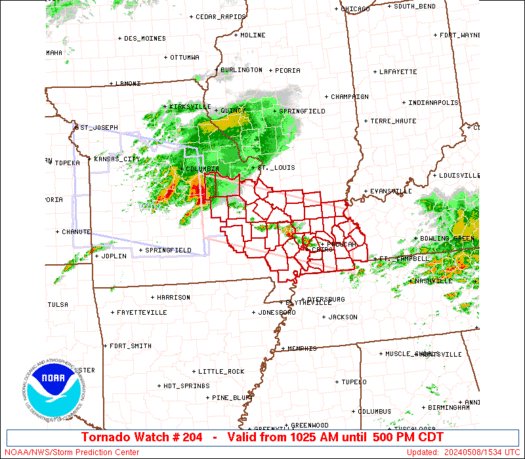
SPC Tornado Watch 212
in Storm Prediction Center RSS Feed
Posted
URGENT - IMMEDIATE BROADCAST REQUESTED
Tornado Watch Number 212
NWS Storm Prediction Center Norman OK
440 PM CDT Wed May 8 2024

The NWS Storm Prediction Center has issued a

* Tornado Watch for portions of
  Southern Illinois
  Western Kentucky
  Southern Missouri

* Effective this Wednesday afternoon from 440 PM until Midnight
  CDT.

* Primary threats include...
  A few tornadoes and a couple intense tornadoes likely
  Widespread large hail and scattered very large hail events to
    2.5 inches in diameter likely
  Widespread damaging winds and isolated significant gusts to 75
    mph likely

SUMMARY...Multiple rounds of severe thunderstorms will affect the
watch area through the afternoon and evening, posing a risk of large
hail and damaging winds.  A few tornadoes are also expected.

The tornado watch area is approximately along and 50 statute miles
north and south of a line from 20 miles west of Springfield MO to 40
miles north northeast of Fort Campbell KY. For a complete depiction
of the watch see the associated watch outline update (WOUS64 KWNS
WOU2).

PRECAUTIONARY/PREPAREDNESS ACTIONS...

REMEMBER...A Tornado Watch means conditions are favorable for
tornadoes and severe thunderstorms in and close to the watch
area. Persons in these areas should be on the lookout for
threatening weather conditions and listen for later statements
and possible warnings.

&&

OTHER WATCH INFORMATION...CONTINUE...WW 204...WW 205...WW
206...WW 207...WW 208...WW 209...WW 210...WW 211...

AVIATION...Tornadoes and a few severe thunderstorms with hail
surface and aloft to 2.5 inches. Extreme turbulence and surface wind
gusts to 65 knots. A few cumulonimbi with maximum tops to 500. Mean
storm motion vector 26035.

...Hart
Read moreView the full article