


NorthGeorgiaWX
-
Posts
34,537 -
Joined
-
Last visited
-
Days Won
1,499
Content Type
Profiles
Blogs
Forums
Gallery
Events
Store
Downloads
Posts posted by NorthGeorgiaWX
-
-
WW 0162 Status Updates

STATUS REPORT ON WW 162

SEVERE WEATHER THREAT CONTINUES RIGHT OF A LINE FROM 15 NNE HOU
TO 20 W LCH TO 25 ENE LCH TO 35 NNW LFT TO 30 SSW HEZ.

..LEITMAN..04/29/24

ATTN...WFO...LCH...LIX...HGX...


STATUS REPORT FOR WS 162

SEVERE WEATHER THREAT CONTINUES FOR THE FOLLOWING AREAS

LAC001-023-033-037-045-047-053-055-077-097-099-101-113-121-125-
291140-

LA
.    LOUISIANA PARISHES INCLUDED ARE

ACADIA               CAMERON             EAST BATON ROUGE
EAST FELICIANA       IBERIA              IBERVILLE
JEFFERSON DAVIS      LAFAYETTE           POINTE COUPEE
ST. LANDRY           ST. MARTIN          ST. MARY
VERMILION            WEST BATON ROUGE    WEST FELICIANA


MSC005-157-291140-

MS
.    MISSISSIPPI COUNTIES INCLUDED ARE

AMITE                WILKINSON


TXC071-245-291140-

TX
.    TEXAS COUNTIES INCLUDED ARE
Read more -
WW 162 SEVERE TSTM LA MS TX CW 290655Z - 291400Z
URGENT - IMMEDIATE BROADCAST REQUESTED
Severe Thunderstorm Watch Number 162
NWS Storm Prediction Center Norman OK
155 AM CDT Mon Apr 29 2024

The NWS Storm Prediction Center has issued a

* Severe Thunderstorm Watch for portions of
  South central and southwest Louisiana
  Extreme southwest Mississippi
  Southeast Texas
  Coastal Waters

* Effective this Monday morning from 155 AM until 900 AM CDT.

* Primary threats include...
  Scattered damaging wind gusts to 65 mph possible
  Isolated large hail events to 1 inch in diameter possible
  A tornado or two possible

SUMMARY...A large convective cluster will continue to develop slowly
southeastward through the early morning hours across southeast Texas
and southwest/south central Louisiana.  Embedded bowing segments
will pose the threat for occasional damaging winds up to 65 mph, and
the stronger embedded cells could produce isolated large hail near 1
inch in diameter.  An isolated tornado or two may also occur with
circulations embedded in the larger band of storms.

The severe thunderstorm watch area is approximately along and 55
statute miles north and south of a line from 60 miles west northwest
of Port Arthur TX to 50 miles east of Lafayette LA. For a complete
depiction of the watch see the associated watch outline update
(WOUS64 KWNS WOU2).

PRECAUTIONARY/PREPAREDNESS ACTIONS...

REMEMBER...A Severe Thunderstorm Watch means conditions are
favorable for severe thunderstorms in and close to the watch area.
Persons in these areas should be on the lookout for threatening
weather conditions and listen for later statements and possible
warnings. Severe thunderstorms can and occasionally do produce
tornadoes.

&&

OTHER WATCH INFORMATION...CONTINUE...WW 160...

AVIATION...A few severe thunderstorms with hail surface and aloft to
1 inch. Extreme turbulence and surface wind gusts to 55 knots. A few
cumulonimbi with maximum tops to 550. Mean storm motion vector
30015.

...Thompson
Read more -
WW 0162 Status Updates
STATUS REPORT ON WW 162

SEVERE WEATHER THREAT CONTINUES RIGHT OF A LINE FROM 15 NNE HOU
TO 20 W LCH TO 25 ENE LCH TO 35 NNW LFT TO 30 SSW HEZ.

..LEITMAN..04/29/24

ATTN...WFO...LCH...LIX...HGX...


STATUS REPORT FOR WS 162

SEVERE WEATHER THREAT CONTINUES FOR THE FOLLOWING AREAS

LAC001-023-033-037-045-047-053-055-077-097-099-101-113-121-125-
291140-

LA
.    LOUISIANA PARISHES INCLUDED ARE

ACADIA               CAMERON             EAST BATON ROUGE
EAST FELICIANA       IBERIA              IBERVILLE
JEFFERSON DAVIS      LAFAYETTE           POINTE COUPEE
ST. LANDRY           ST. MARTIN          ST. MARY
VERMILION            WEST BATON ROUGE    WEST FELICIANA


MSC005-157-291140-

MS
.    MISSISSIPPI COUNTIES INCLUDED ARE

AMITE                WILKINSON


TXC071-245-291140-

TX
.    TEXAS COUNTIES INCLUDED ARE
Read more -
WW 162 SEVERE TSTM LA MS TX CW 290655Z - 291400Z
URGENT - IMMEDIATE BROADCAST REQUESTED
Severe Thunderstorm Watch Number 162
NWS Storm Prediction Center Norman OK
155 AM CDT Mon Apr 29 2024

The NWS Storm Prediction Center has issued a

* Severe Thunderstorm Watch for portions of
  South central and southwest Louisiana
  Extreme southwest Mississippi
  Southeast Texas
  Coastal Waters

* Effective this Monday morning from 155 AM until 900 AM CDT.

* Primary threats include...
  Scattered damaging wind gusts to 65 mph possible
  Isolated large hail events to 1 inch in diameter possible
  A tornado or two possible

SUMMARY...A large convective cluster will continue to develop slowly
southeastward through the early morning hours across southeast Texas
and southwest/south central Louisiana.  Embedded bowing segments
will pose the threat for occasional damaging winds up to 65 mph, and
the stronger embedded cells could produce isolated large hail near 1
inch in diameter.  An isolated tornado or two may also occur with
circulations embedded in the larger band of storms.

The severe thunderstorm watch area is approximately along and 55
statute miles north and south of a line from 60 miles west northwest
of Port Arthur TX to 50 miles east of Lafayette LA. For a complete
depiction of the watch see the associated watch outline update
(WOUS64 KWNS WOU2).

PRECAUTIONARY/PREPAREDNESS ACTIONS...

REMEMBER...A Severe Thunderstorm Watch means conditions are
favorable for severe thunderstorms in and close to the watch area.
Persons in these areas should be on the lookout for threatening
weather conditions and listen for later statements and possible
warnings. Severe thunderstorms can and occasionally do produce
tornadoes.

&&

OTHER WATCH INFORMATION...CONTINUE...WW 160...

AVIATION...A few severe thunderstorms with hail surface and aloft to
1 inch. Extreme turbulence and surface wind gusts to 55 knots. A few
cumulonimbi with maximum tops to 550. Mean storm motion vector
30015.

...Thompson
Read more -
Day 4-8 Outlook
Day 4-8 Convective Outlook
NWS Storm Prediction Center Norman OK
0344 AM CDT Mon Apr 29 2024

Valid 021200Z - 071200Z

...DISCUSSION...
...D4/Thursday - Southern Plains into the mid/upper Mississippi
Valley...
Extensive convection appears likely from the southern Plains
northeastward into the mid/upper MS Valley on Thursday, as a
relatively deep upper trough continues to impinge upon a broad and
moist warm sector. Deep-layer shear will be sufficient to support
organized convection, and pockets of severe potential are likely to
evolve within this regime. However, most guidance suggests that one
or more MCSs will be ongoing Thursday morning, with widespread
cloudiness and precipitation possible across much of the warm
sector. Storm redevelopment will be possible as a cold front moves
into the region, but magnitude of instability and potential
influence of convective outflow remain too uncertain to delineate a
15% area.

...D5/Friday into D8/Monday...
Predictability regarding the synoptic pattern wanes rather quickly
by the weekend. In general, a cold front is expected to move
southeastward on D5/Friday and then stall from the southern Plains
into the lower MS Valley. Rich low-level moisture will support daily
destabilization along/south of the front. However, potential for
either storm development across TX or for moisture/instability to be
drawn northward into a larger portion of the Plains remains quite
uncertain into early next week.
Read more -
SPC 0730Z Day 3 Outlook
Day 3 Convective Outlook
NWS Storm Prediction Center Norman OK
0230 AM CDT Mon Apr 29 2024

Valid 011200Z - 021200Z

...THERE IS A SLIGHT RISK OF SEVERE THUNDERSTORMS FOR PARTS OF THE
CENTRAL/SOUTHERN GREAT PLAINS...

...SUMMARY...
Scattered severe thunderstorms will be possible across parts of the
central and southern Plains on Wednesday. A few tornadoes will be
possible (including potential for a strong tornado), in addition to
large to very large hail and damaging winds.

...Synopsis...
In the wake of a strong shortwave trough moving toward the upper
Great Lakes, a broad upper trough is forecast to move slowly
eastward toward the central CONUS on Wednesday. A surface low is
forecast to deepen across the south-central High Plains, with rich
low-level moisture expected to stream northward across the warm
sector. A dryline will extend south of the low during the afternoon,
while a warm front will move northward toward the KS/NE border.
Farther south, a secondary mid/upper-level jet maximum may
overspread parts of west/southwest TX.

...Parts of the central/southern Plains...
A favorable conditional environment for severe thunderstorms will
likely develop across parts of the warm sector on Wednesday, and
supercells capable of all severe hazards will be possible. Storm
coverage and evolution remain uncertain, however.

Steep midlevel lapse rates atop rich low-level moisture (with
dewpoints in the mid 60s to near 70 F) will support strong
destabilization along/east of the dryline and south of the warm
front by Wednesday afternoon. Mid/upper-level flow will remain
relatively modest across most of the warm sector, but veering wind
profiles will support effective shear generally above 40 kt,
sufficient for supercell development in the presence of strong
instability.

The primary uncertainty is the coverage and location of storm
diurnal storm development, with only subtle vorticity maxima
expected to overspread the warm sector. However, at least isolated
storm development will be possible near the dryline, with increasing
storm coverage expected near the warm front by afternoon/evening.
Any sustained supercells will pose a threat of very large hail and
tornadoes, with a strong tornado possible as the low-level jet
increases into the evening. MCS development will also be possible
Wednesday evening near/north of the warm front, aided by a strong
low-level jet.

Farther south, the subtle subtropical shortwave trough could support
a secondary maximum of storm coverage from southwest into central
TX, though this scenario is more uncertain. The Marginal Risk has
been expanded across much of TX, with some potential for initial
isolated supercells to evolve into one or more storm clusters into
Wednesday evening as they move eastward.

..Dean.. 04/29/2024
Read more -
SPC Day 1 Fire Weather Outlook
Day 1 Fire Weather Outlook
NWS Storm Prediction Center Norman OK
0153 AM CDT Mon Apr 29 2024

Valid 291200Z - 301200Z

...NO CRITICAL AREAS...

...Synopsis...
Fire weather concerns are expected to remain low across the CONUS
today. Weak lee surface troughing will continue to bring localized
breezes across portions of the southern High Plains. Height rises
and weakening flow aloft should keep coverage of this threat
limited, precluding the need to include any areas at this time.
Afternoon relative humidity will still drop as low as 15 percent
with localized periods of Elevated fire weather, main across eastern
New Mexico.

..Thornton.. 04/29/2024

...Please see www.spc.noaa.gov/fire for graphic product...
Read more -
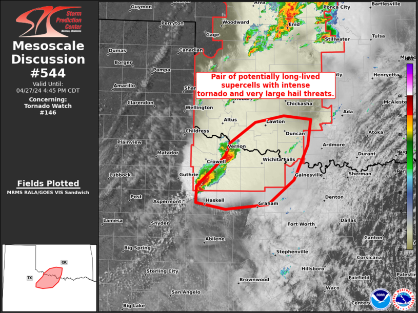
MD 0544 CONCERNING TORNADO WATCH 146... FOR WESTERN NORTH TX AND SOUTHWEST OK
Mesoscale Discussion 0544
NWS Storm Prediction Center Norman OK
0319 PM CDT Sat Apr 27 2024

Areas affected...Western north TX and southwest OK

Concerning...Tornado Watch 146...

Valid 272019Z - 272145Z

The severe weather threat for Tornado Watch 146 continues.

SUMMARY...Pair of potentially long-lived supercells within the
southern portion of WW 146 may evolve with an intense tornado and
very large hail threat.

DISCUSSION...A potentially long-lived, slow-moving discrete
supercell is centered over Knox County, TX. This supercell appears
to be anchored along the far southern portion of the broader
convective plume that extends north across OK/KS. With full
insolation in the warm-moist sector inflow to its southeast, its
plausible that a long-lived supercell will persist for the next 2-3
hours. Amid MLCAPE of 3000 J/kg and mid 60s surface dew points to
its southeast, a cyclic tornadic supercell could evolve beyond the
very large hail threat with up to baseballs reported thus far. The
supercell to its northeast in Wilbarger County, TX will also have
potential to further intensify as it spreads towards and northwest
of the Wichita Falls vicinity, given 0-1 km SRH of 100-200 m2/s2 per
FDR VWP data.

..Grams.. 04/27/2024

...Please see www.spc.noaa.gov for graphic product...

ATTN...WFO...FWD...OUN...SJT...

LAT...LON   34049929 34279919 34669862 34789799 34719739 34239746
            33609778 33159835 33059928 33179992 33479991 34049929
Read more -
MD 0545 CONCERNING TORNADO WATCH 145...147... FOR EASTERN KANSAS INTO NORTHERN MISSOURI AND SOUTHERN IOWA
Mesoscale Discussion 0545
NWS Storm Prediction Center Norman OK
0340 PM CDT Sat Apr 27 2024

Areas affected...eastern Kansas into northern Missouri and southern
Iowa

Concerning...Tornado Watch 145...147...

Valid 272040Z - 272215Z

The severe weather threat for Tornado Watch 145, 147 continues.

SUMMARY...The threat for brief tornadoes as well as damaging outflow
winds and hail continues within the watch areas, and may spread
east, necessitating additional watch areas.

DISCUSSION...Supercells formed along a retreating boundary/warm
front which now extends from northeast KS and northwest MO, and from
southwest IA into southern WI. Low-level shear is maximized near
this boundary with 0-1 SRH near 150 m2/s2 and weaker values into the
open warm sector.

Heating continues along the boundary, and the 18Z DVN sounding shows
ample instability and lapse rates to sustain strong to severe
storms, with generally unidirectional shear profiles. However, only
minimal low-level hodograph augmentation may be necessary for a
tornado risk with any supercells that move across northern MO/IA
through the afternoon. As such, the threat may eventually extend
beyond WW 147, and another watch and/or extension may become
necessary depending on trends.

Farther south into eastern KS and western MO, outflow from initial
activity extends from northeast KS into north-central OK, while an
unstable air mass remains just to the east. MLCAPE over 2500 J/kg as
well as ample deep-layer shear will support supercells and or
damaging bows this evening, with all modes of severe possible.

..Jewell.. 04/27/2024

...Please see www.spc.noaa.gov for graphic product...

ATTN...WFO...ILX...LSX...DVN...DMX...EAX...OAX...TOP...

LAT...LON   39769312 39559354 39019394 38299431 38129512 38169538
            38419551 38809553 39339566 39619617 39739625 39879618
            40969460 42199236 42309089 41789025 41039038 40319140
            39769312
Read more -
WW 0146 Status Updates
STATUS REPORT ON WW 146

THE SEVERE WEATHER THREAT CONTINUES ACROSS THE ENTIRE WATCH AREA.

FOR ADDITIONAL INFORMATION SEE MESOSCALE DISCUSSION 0544.

..GRAMS..04/27/24

ATTN...WFO...OUN...


STATUS REPORT FOR WT 146

SEVERE WEATHER THREAT CONTINUES FOR THE FOLLOWING AREAS

OKC003-009-011-015-017-027-031-033-039-043-047-049-051-053-055-
057-065-067-071-073-075-083-087-093-103-109-119-129-137-141-149-
151-153-272140-

OK
.    OKLAHOMA COUNTIES INCLUDED ARE

ALFALFA              BECKHAM             BLAINE
CADDO                CANADIAN            CLEVELAND
COMANCHE             COTTON              CUSTER
DEWEY                GARFIELD            GARVIN
GRADY                GRANT               GREER
HARMON               JACKSON             JEFFERSON
KAY                  KINGFISHER          KIOWA
LOGAN                MCCLAIN             MAJOR
NOBLE                OKLAHOMA            PAYNE
ROGER MILLS          STEPHENS            TILLMAN
WASHITA              WOODS               WOODWARD


TXC009-023-077-155-197-275-485-487-272140-

TX
.    TEXAS COUNTIES INCLUDED ARE
Read more -
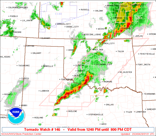
WW 146 TORNADO OK TX 271740Z - 280100Z
URGENT - IMMEDIATE BROADCAST REQUESTED
Tornado Watch Number 146
NWS Storm Prediction Center Norman OK
1240 PM CDT Sat Apr 27 2024

The NWS Storm Prediction Center has issued a

* Tornado Watch for portions of
  Western Oklahoma
  Northwest Texas

* Effective this Saturday afternoon and evening from 1240 PM
  until 800 PM CDT.

...THIS IS A PARTICULARLY DANGEROUS SITUATION...

* Primary threats include...
  Several tornadoes and a few intense tornadoes likely
  Widespread large hail and scattered very large hail events to 3
    inches in diameter likely
  Widespread damaging winds and isolated significant gusts to 75
    mph likely

SUMMARY...Intense thunderstorms are expected to develop this
afternoon along and east of a dryline over western Oklahoma and
northwest Texas.  Supercells are expected, capable of very large
hail and damaging winds.  The most intense cells may also produce
strong or potentially long-tracked tornadoes.

The tornado watch area is approximately along and 70 statute miles
east and west of a line from 35 miles east northeast of Alva OK to
45 miles southwest of Wichita Falls TX. For a complete depiction of
the watch see the associated watch outline update (WOUS64 KWNS
WOU6).

PRECAUTIONARY/PREPAREDNESS ACTIONS...

REMEMBER...A Tornado Watch means conditions are favorable for
tornadoes and severe thunderstorms in and close to the watch
area. Persons in these areas should be on the lookout for
threatening weather conditions and listen for later statements
and possible warnings.

&&

OTHER WATCH INFORMATION...CONTINUE...WW 144...WW 145...

AVIATION...Tornadoes and a few severe thunderstorms with hail
surface and aloft to 3 inches. Extreme turbulence and surface wind
gusts to 65 knots. A few cumulonimbi with maximum tops to 500. Mean
storm motion vector 24035.

...Hart
Read more -
-
-
WW 148 SEVERE TSTM KS 271955Z - 280200Z
URGENT - IMMEDIATE BROADCAST REQUESTED
Severe Thunderstorm Watch Number 148
NWS Storm Prediction Center Norman OK
255 PM CDT Sat Apr 27 2024

The NWS Storm Prediction Center has issued a

* Severe Thunderstorm Watch for portions of
  Western Kansas

* Effective this Saturday afternoon and evening from 255 PM until
  900 PM CDT.

* Primary threats include...
  Scattered large hail and isolated very large hail events to 2
    inches in diameter likely
  Scattered damaging wind gusts to 70 mph likely
  A tornado or two possible

SUMMARY...Thunderstorms will develop along a surface boundary across
western Kansas this afternoon.  The stronger cells will pose a risk
of large hail.

The severe thunderstorm watch area is approximately along and 55
statute miles north and south of a line from 70 miles west northwest
of Garden City KS to 55 miles northeast of Russell KS. For a
complete depiction of the watch see the associated watch outline
update (WOUS64 KWNS WOU8).

PRECAUTIONARY/PREPAREDNESS ACTIONS...

REMEMBER...A Severe Thunderstorm Watch means conditions are
favorable for severe thunderstorms in and close to the watch area.
Persons in these areas should be on the lookout for threatening
weather conditions and listen for later statements and possible
warnings. Severe thunderstorms can and occasionally do produce
tornadoes.

&&

OTHER WATCH INFORMATION...CONTINUE...WW 145...WW 146...WW 147...

AVIATION...A few severe thunderstorms with hail surface and aloft to
2 inches. Extreme turbulence and surface wind gusts to 60 knots. A
few cumulonimbi with maximum tops to 500. Mean storm motion vector
24035.

...Hart
Read more -
SPC Day 3-8 Fire Weather Outlook
Day 3-8 Fire Weather Outlook
NWS Storm Prediction Center Norman OK
0211 PM CDT Sat Apr 27 2024

Valid 291200Z - 051200Z

Zonal mid-level flow will become established across the CONUS, with
multiple embedded shortwave troughs expected to traverse the
northern half of the CONUS for the upcoming week. During the middle
into late week period, surface lee troughing will encourage dry and
occasionally breezy conditions across the southern High Plains as a
surface cold front sweeps across the northern Rockies into the
Plains.

Guidance consensus shows potential for at least Elevated equivalent
dry and breezy conditions along/behind the surface cold front across
the northern High Plains for Day 4 (Tuesday). However, fuels appear
modestly receptive to fire spread, precluding the addition of
Critical probabilities at this time. Similarly, Elevated equivalent
dry/windy conditions may also accompany the post-dryline environment
over eastern New Mexico into far western Texas. However, questions
remain this far in advance how strong the post-dryline winds will
become, with Critical probabilities withheld for now.

..Squitieri.. 04/27/2024

...Please see www.spc.noaa.gov/fire for graphic product...
Read more -
WW 0145 Status Updates
STATUS REPORT ON WW 145

THE SEVERE WEATHER THREAT CONTINUES ACROSS THE ENTIRE WATCH AREA.

..JEWELL..04/27/24

ATTN...WFO...DDC...ICT...TOP...OAX...


STATUS REPORT FOR WT 145

SEVERE WEATHER THREAT CONTINUES FOR THE FOLLOWING AREAS

KSC007-009-013-015-017-019-027-029-031-033-035-041-045-047-049-
053-061-073-077-079-085-087-095-097-105-111-113-115-117-127-131-
139-143-145-149-151-155-159-161-167-169-173-177-185-191-197-201-
272040-

KS
.    KANSAS COUNTIES INCLUDED ARE

BARBER               BARTON              BROWN
BUTLER               CHASE               CHAUTAUQUA
CLAY                 CLOUD               COFFEY
COMANCHE             COWLEY              DICKINSON
DOUGLAS              EDWARDS             ELK
ELLSWORTH            GEARY               GREENWOOD
HARPER               HARVEY              JACKSON
JEFFERSON            KINGMAN             KIOWA
LINCOLN              LYON                MCPHERSON
MARION               MARSHALL            MORRIS
NEMAHA               OSAGE               OTTAWA
PAWNEE               POTTAWATOMIE        PRATT
RENO                 RICE                RILEY
RUSSELL              SALINE              SEDGWICK
SHAWNEE              STAFFORD            SUMNER
WABAUNSEE            WASHINGTON
Read more -
WW 145 TORNADO KS NE 271650Z - 280000Z
URGENT - IMMEDIATE BROADCAST REQUESTED
Tornado Watch Number 145
NWS Storm Prediction Center Norman OK
1150 AM CDT Sat Apr 27 2024

The NWS Storm Prediction Center has issued a

* Tornado Watch for portions of
  Central and Northeast Kansas
  Southeast Nebraska

* Effective this Saturday morning and evening from 1150 AM until
  700 PM CDT.

* Primary threats include...
  A few tornadoes and a couple intense tornadoes likely
  Widespread large hail and scattered very large hail events to
    2.5 inches in diameter likely
  Scattered damaging winds likely with isolated significant gusts
    to 75 mph possible

SUMMARY...Thunderstorms will develop across parts of central and
northeast Kansas through the afternoon in a very moist and unstable
environment.  The strongest cells will be supercells capable of very
large hail and tornadoes.  A few strong tornadoes are possible.

The tornado watch area is approximately along and 80 statute miles
east and west of a line from 70 miles west northwest of Saint Joseph
MO to 25 miles southeast of Medicine Lodge KS. For a complete
depiction of the watch see the associated watch outline update
(WOUS64 KWNS WOU5).

PRECAUTIONARY/PREPAREDNESS ACTIONS...

REMEMBER...A Tornado Watch means conditions are favorable for
tornadoes and severe thunderstorms in and close to the watch
area. Persons in these areas should be on the lookout for
threatening weather conditions and listen for later statements
and possible warnings.

&&

OTHER WATCH INFORMATION...CONTINUE...WW 144...

AVIATION...Tornadoes and a few severe thunderstorms with hail
surface and aloft to 2.5 inches. Extreme turbulence and surface wind
gusts to 65 knots. A few cumulonimbi with maximum tops to 500. Mean
storm motion vector 25030.

...Hart
Read more -
-


SPC - No MDs are in effect as of Mon Apr 29 10:45:08 UTC 2024
in Storm Prediction Center RSS Feed
Posted
View the full article