


NorthGeorgiaWX
-
Posts
34,534 -
Joined
-
Last visited
-
Days Won
1,499
Content Type
Profiles
Blogs
Forums
Gallery
Events
Store
Downloads
Posts posted by NorthGeorgiaWX
-
-
SPC Day 1 Fire Weather Outlook

Day 1 Fire Weather Outlook
NWS Storm Prediction Center Norman OK
1120 AM CDT Thu Apr 25 2024

Valid 251700Z - 261200Z

...CRITICAL FIRE WEATHER AREA FOR THE SOUTHERN HIGH PLAINS AND
SOUTHERN NEW MEXICO...

Elevated to critical conditions have started to develop across
southeast New Mexico. Expect these conditions to expand/worsen
through the day as mid-level flow strengthens and lee cyclogenesis
continues. Expanded the Elevated delineation slightly farther north
based on current and expected position of the front and dryline.
Otherwise, no changes were necessary. See previous discussion below.

..Bentley.. 04/25/2024

.PREV DISCUSSION... /ISSUED 0114 AM CDT Thu Apr 25 2024/

...Synopsis...
A midlevel trough will track eastward across the Southwest, while an
accompanying 60-70-kt midlevel southwesterly jet overspreads
southern NM and the southern High Plains. This will promote rapid
deepening of a lee cyclone over eastern CO, while a
southward-extending dryline sharpens over west TX. This large-scale
pattern evolution will yield an expansive area of critical
fire-weather conditions across the aforementioned areas, with
high-end critical conditions expected over eastern NM.

...Southern New Mexico and the Southern High Plains...
Behind the sharpening dryline, strong downslope warming/drying and
diurnal heating will contribute to a deep/dry boundary layer,
characterized by surface temperatures in the mid/upper 80s and
single-digit to lower-teens RH. Here, a tightening surface pressure
gradient peripheral to the deepening lee cyclone, and mixing into
the strong flow aloft, will support 25-35 mph sustained
southwesterly surface winds (with gusts upwards of 45 mph). These
conditions will yield an expansive area of high-end critical
fire-weather conditions, given modestly receptive fuels.

The overlap of strongest winds and lowest relative humidity is
expected over eastern NM, where extremely critical meteorological
conditions are likely. However, a lack of abundant and very dry
fuels over the area precludes such highlights at this time.

...Please see www.spc.noaa.gov/fire for graphic product...
Read more -
SPC 1300Z Day 1 Outlook
Day 1 Convective Outlook
NWS Storm Prediction Center Norman OK
0731 AM CDT Thu Apr 25 2024

Valid 251300Z - 261200Z

...THERE IS AN ENHANCED RISK OF SEVERE THUNDERSTORMS THIS EVENING
ACROSS WESTERN KS AND TONIGHT ACROSS NORTHWEST TX INTO CENTRAL OK...

...SUMMARY...
Very large hail up to 3 inches in diameter and a strong tornado or
two will be possible this evening across western Kansas.  Large hail
up to 2.5 inches in diameter, damaging winds to 70 mph and a few
tornadoes will be possible tonight from northwest Texas into central
Oklahoma.

...Synopsis...
A midlevel shortwave trough and associated 70 kt jet will eject
northeastward toward western KS by late tonight and Friday morning.
An associated lee cyclone is expected to deepen this afternoon
across northeast CO, with a sharpening dryline arcing to its south
across western KS and the TX/OK Panhandles.  Farther east, a warm
front will continue to move northward from OK into KS, though
northward progress of the front will be slowed by elevated
convection (posing an isolated large hail threat) that will
reinforce the cool side of the boundary during the day.  A somewhat
bimodal threat distribution is expected - the warm sector in western
KS and a second corridor overnight from northwest TX into OK.

...Western KS this afternoon/evening...
An unstable warm sector will be present through this evening, with
boundary-layer dewpoints in the 60s beneath steep midlevel lapse
rates.  The base of the elevated mixed layer will be relatively
warm, suggesting the need for surface temperatures into the 80s on
the immediate moist side of the dryline.  The better potential for
storm development this afternoon will be across western KS, where
dryline parcel residence times will be longer and in closer
proximity to the left-exit region of the approaching mid-upper jet.
The initial dryline storms will likely become supercells capable of
producing very large hail of 2-3 inches in diameter, and these
storms could continue northeastward as elevated supercells atop the
warm front.  The potential for a strong tornado or two will increase
this evening as the storms encounter richer low-level moisture and
increasing low-level shear.  However, the window of opportunity will
not be particularly large given the presence of a rain-reinforced
front to the northeast and increasing convective inhibition by late
evening.

...Northwest TX into OK overnight...
A general consensus of most overnight forecast guidance suggests a
southern corridor of greater hail/wind threat starting early tonight
just off the Caprock and then spreading northeastward over northwest
TX into southwest/central OK early Friday morning.  Thunderstorm
initiation will become more probable by 03-06z in association with
cooling/moistening at the base of the elevated mixed layer,
coincident with the beginning of eastward movement of the
dryline/Pacific cold front along the trailing influence of the
ejecting midlevel trough.  Storm mode will likely trend to
clusters/line segments while spreading northeastward.
Boundary-layer dewpoints approaching the upper 60s beneath steep
midlevel lapse rates will contribute to MUCAPE in excess of 2000
J/kg through the overnight hours, which will favor the potential for
both large hail (especially with any embedded supercells) and
damaging winds of 60-70 mph.  A few tornadoes may also occur with
embedded circulations as low-level shear increases tonight.

...TX Panhandle/western OK this afternoon/evening...
A conditionally favorable environment for supercells with very large
hail and tornadoes will exist this afternoon/evening across the
eastern TX Panhandle into western OK.  The primary uncertainty here
will be lingering convective inhibition and substantial uncertainty
in storm coverage/location along the dryline.  For these reasons,
have lowered the overall severe threat, but maintained some
conditional significant severe potential.

..Thompson/Kerr.. 04/25/2024
Read more -
No Mesoscale Discussions are in effect as of Thu Apr 25 12:01:02 UTC 2024.
-
No watches are valid as of Wed Apr 24 03:02:01 UTC 2024.
-
-
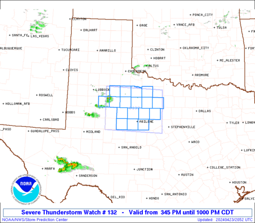
WW 132 SEVERE TSTM TX 232045Z - 240300Z
URGENT - IMMEDIATE BROADCAST REQUESTED
Severe Thunderstorm Watch Number 132
NWS Storm Prediction Center Norman OK
345 PM CDT Tue Apr 23 2024

The NWS Storm Prediction Center has issued a

* Severe Thunderstorm Watch for portions of
  Northwest Texas

* Effective this Tuesday afternoon and evening from 345 PM until
  1000 PM CDT.

* Primary threats include...
  Scattered large hail and isolated very large hail events to 2.5
    inches in diameter possible
  Scattered damaging wind gusts to 70 mph possible

SUMMARY...Isolated to scattered thunderstorms are forecast to
develop this afternoon into the evening.  A few of the stronger
storms will probably evolve into supercells and pose a risk for
large to very large hail and severe gusts.

The severe thunderstorm watch area is approximately along and 60
statute miles north and south of a line from 95 miles west northwest
of Abilene TX to 75 miles east northeast of Abilene TX. For a
complete depiction of the watch see the associated watch outline
update (WOUS64 KWNS WOU2).

PRECAUTIONARY/PREPAREDNESS ACTIONS...

REMEMBER...A Severe Thunderstorm Watch means conditions are
favorable for severe thunderstorms in and close to the watch area.
Persons in these areas should be on the lookout for threatening
weather conditions and listen for later statements and possible
warnings. Severe thunderstorms can and occasionally do produce
tornadoes.

&&

AVIATION...A few severe thunderstorms with hail surface and aloft to
2.5 inches. Extreme turbulence and surface wind gusts to 60 knots. A
few cumulonimbi with maximum tops to 450. Mean storm motion vector
27030.

...Smith
Read more -
SPC Day 3-8 Fire Weather Outlook
Day 3-8 Fire Weather Outlook
NWS Storm Prediction Center Norman OK
0324 PM CDT Tue Apr 23 2024

Valid 251200Z - 011200Z

An active fire weather pattern will become situated over the
southern High Plains late this week through the weekend. The passage
of multiple mid-level troughs will encourage surface cyclone
development and the eastward surge of a dryline each day
Thursday-Sunday along the southern High Plains. Critically dry and
windy conditions will become situated behind the dryline each day,
with 70% Critical probabilities maintained where very windy and dry
surface conditions will coincide for several hours during the
afternoon. Furthermore, locally Extremely Critical surface winds/RH
cannot be ruled out over portions of eastern New Mexico into far
western Texas for Day 3/Thursday or Day 5/Saturday, when the core
mid-level jet stream from both upper-level troughs overspread the
region. By early next week, the ejection of these mid-level troughs,
in favor of upper ridging, will encourage a more quiescent fire
weather pattern over the southern High Plains, though dry surface
conditions should persist.

..Squitieri.. 04/23/2024

...Please see www.spc.noaa.gov/fire for graphic product...
Read more -
SPC 2000Z Day 1 Outlook
Day 1 Convective Outlook
NWS Storm Prediction Center Norman OK
0256 PM CDT Tue Apr 23 2024

Valid 232000Z - 241200Z

...THERE IS A SLIGHT RISK OF SEVERE THUNDERSTORMS ACROSS NORTHWEST
TEXAS...

...SUMMARY...
Isolated severe thunderstorms capable of producing large hail
(potentially 2+ inch diameter) and gusts to 65 mph will be possible
this afternoon and evening across northwest Texas.

...20Z Update...
Overall forecast outlined in the previous discussion (appended
below) remains valid. As mentioned in recently issued MCD 506, a
supercell or two should develop across a portion of western North
Texas through late afternoon, with large hail of 1.5 to 2.5 inches
in diameter and localized severe gusts of 60-70 mph possible. An
isolated storm or two is also possible farther south in the Texas
Trans Pecos vicinity. Marginally severe hail (i.e. around 1" in
diameter) and damaging gusts are possible here as well.

Farther north, isolated thunderstorms are still anticipated from
northern IL into Lower MI ahead of an approaching shortwave trough
and associated cold front. A few strong to severe storms are
possible with small to marginally severe hail and damaging winds as
the primary hazards (as mentioned in recently issued MCD 507).

...Early tomorrow morning from TX Panhandle into
north-central/central OK...
Elevated thunderstorms may develop from the northeast TX/eastern OK
Panhandles into central/north-central OK within the warm-air
advection regime along the northeastern edge of the returning
low-level moisture. Steep mid-level lapse rates and favorable
cloud-bearing layer shear could support an isolated instance or two
of hail with initial development. However, severe coverage is
currently expected to remain less than 5%, precluding the
introduction of any outlook areas.

..Mosier.. 04/23/2024

.PREV DISCUSSION... /ISSUED 1123 AM CDT Tue Apr 23 2024/

...Northwest TX...
Visible satellite imagery and surface analysis this morning indicate
the initial stage of moisture return is occurring across the
southern Great Plains in the wake of a frontal intrusion into the
Gulf a few days ago.  A mid-level ridge will increasingly become
established across the central/southern Rockies and adjacent High
Plains as a Great Lakes disturbance gradually becomes more displaced
from the region.  An associated cold front will move southward
across KS/OK before eventually stalling tonight across southeast OK
and northwest TX.  Weak lee cyclogenesis will aid in maintaining a
southerly low-level fetch across central into west TX as strong
heating results in a sharpening dryline by late afternoon.  Isolated
thunderstorm development will be most probable near the triple point
20-22Z.  Steep lapse rates coupled with adequate moisture (1500-2000
J/kg MLCAPE) and veering flow beneath moderate westerlies, will
support an initial supercell mode.  Isolated very large hail of
2-2.5 inches in diameter will be the main threat, along with a few
55-65 mph gusts.

...Northern IL/southeast WI/Lower MI late this afternoon/evening...
Have not changed the existing outlook for this region due primarily
to consistency in model data and the forecast conceptual model not
deviating.  Water-vapor imagery this morning shows a mid-level
trough over the Upper Midwest and this will continue southeast into
the central Great Lakes by mid evening.  An associated surface
trough will likewise move southeastward, and this trough will be
preceded by a band of rain with minimal buoyancy.  Behind the rain
band, surface heating with steepening low-level lapse rates and
cooling midlevel temperatures will support weak surface-based
buoyancy just ahead of a secondary frontal surge.  Some low-topped
convection will be possible late this afternoon through late evening
from northern IL/southeast WI into Lower MI.  The stronger storms
could yield a localized marginal hail/damaging wind threat.
Read more -
SPC Day 2 Fire Weather Outlook
Day 2 Fire Weather Outlook
NWS Storm Prediction Center Norman OK
0213 PM CDT Tue Apr 23 2024

Valid 241200Z - 251200Z

...NO CRITICAL AREAS...

The previous forecast remains unchanged.

..Squitieri.. 04/23/2024

.PREV DISCUSSION... /ISSUED 0129 AM CDT Tue Apr 23 2024/

...Synopsis...
A low-latitude midlevel trough accompanied by strong southwesterly
flow aloft will impinge on the Southwest, where dry antecedent
conditions will be in place. This will promote a fairly expansive
area of dry/breezy conditions across the region; however, fuels are
generally not supportive of large-fire spread at this time.
Elsewhere, a limited overlap of warm/dry/breezy conditions will
temper fire-weather concerns.

...Please see www.spc.noaa.gov/fire for graphic product...
Read more -
SPC 0730Z Day 3 Outlook
Day 3 Convective Outlook AMEND 1
NWS Storm Prediction Center Norman OK
0131 PM CDT Tue Apr 23 2024

Valid 251200Z - 261200Z

...THERE IS AN ENHANCED RISK OF SEVERE THUNDERSTORMS FROM THE
EASTERN TX PANHANDLE AND WESTERN OK INTO SOUTHWEST/SOUTH-CENTRAL
KS...

AMENDED TO UPDATE FORECAST

...SUMMARY...
Severe thunderstorms are likely from late Thursday afternoon into
Thursday night across parts of the central and southern Great
Plains. Very large hail, severe wind gusts, and strong tornadoes
will all be possible.

Guidance continues to suggest strong buoyancy will be in place ahead
of a negatively tilted shortwave trough ejecting across the southern
High Plains. General forecast expressed in the previous outlook
remains valid, but confidence in an area of greater severe-weather
potential has become more apparent with the most recent guidance.
Late afternoon development is anticipated across the TX Panhandle,
with these storms quickly becoming severe and capable of large to
very large hail up to 3" in diameter. Low-level moisture may be
later to arrive in west-central/southwest KS, delaying convective
initiation to a few hours later than farther south. Large to very
large hail is anticipated with initial development across
west-central/southwest KS as well.

In both of these areas, storms are expected to move
east-northeastward off the dryline, encountering strengthening
low-level southerly flow and environment that is increasingly
favorable for tornadoes. Low-level shear will continue to
strengthening into the early evening, and the overall environment
supports the potential for strong to intense tornadoes if a discrete
mode can be maintained.

--- Previous Discussion issued at 0230 AM CDT Tue Apr 23 2024 ---

...Synopsis...
A shortwave trough initially over the Southwest is forecast to take
on an increasingly negative tilt as it moves eastward towards the
central/southern Plains by Thursday night into Friday morning. In
response, a surface low will consolidate and deepen across the
central High Plains through the day, before moving northeastward
toward northwest KS/southwest NE by Friday morning. An initially
stationary surface boundary will move northward as a warm front
across the central Plains through the day. Along/south of the warm
front, relatively rich low-level moisture will stream northward to
the east of a dryline that will become established from the eastern
TX Panhandle into western KS and eastern CO.

...Southern/central Great Plains...
Coverage of the severe-thunderstorm threat remains somewhat
uncertain, but a couple intense supercells are possible by Thursday
evening near the dryline from western KS into western OK and the
TX/OK Panhandles. Another round of overnight convection will
potentially bring the severe threat eastward into a larger portion
of the central/southern Plains.

The warm sector of the deepening cyclone will likely remain capped
for much of the day, though elevated convection may persist from
parts of central/eastern KS into eastern OK, to the north of the
effective warm front. Increasing moisture beneath steep midlevel
lapse rates will support MLCAPE in excess of 2000 J/kg along/east of
the dryline, as deep-layer shear strengthens across the region
through the day.

Ascent attendant to the approaching shortwave trough will begin to
impinge upon the warm sector by late afternoon, with isolated
supercell development possible near the surface low across southwest
KS and southward down the dryline into the TX Panhandle. Very large
hail (potentially 2-3 inches in diameter) will likely be the primary
initial hazard. A notable increase in low-level flow/shear near and
after 00Z will also support a tornado threat with any supercells
that can persist into the evening across parts of western KS/OK.

While any initial dryline storms may weaken by mid/late evening due
to increasing MLCINH with eastward extent, renewed storm development
is possible overnight along the Pacific cold front from southwest TX
into western/central KS/OK as stronger large-scale ascent
overspreads the region. Steep midlevel lapse rates, moderate
buoyancy, and strong low-level and deep-layer shear will
conditionally support a severe threat with overnight convection
across the warm sector, though storm mode may become complex and
tend toward a linear evolution with time. Severe wind gusts may
become an increasing threat with the nocturnal convection, though
hail and a couple tornadoes will also be possible if semi-discrete
or embedded supercells can be maintained.

...NE/WY border region into northeast CO...
Low-level southeasterly flow will support modest moisture return
into parts of northeast CO, southeast WY, and western NE, to the
north of the deepening cyclone. Thunderstorm development will be
possible near and to the cool side of the effective warm front
during the afternoon. While deep-layer shear will be weaker compared
to areas farther southeast, steep midlevel lapse rates will support
an isolated hail threat. A tornado also cannot be ruled out, if
surface-based storms can be maintained within this regime.

..Mosier.. 04/23/2024
Read more -
SPC 1730Z Day 2 Outlook
Day 2 Convective Outlook
NWS Storm Prediction Center Norman OK
1226 PM CDT Tue Apr 23 2024

Valid 241200Z - 251200Z

...THERE IS A MARGINAL RISK OF SEVERE THUNDERSTORMS FROM WEST TEXAS
INTO MUCH OF OKLAHOMA...

...SUMMARY...
Strong thunderstorms will be possible on Wednesday across parts of
Oklahoma and west Texas. Isolated hail and severe gusts will be the
primary hazards.

...Synopsis...
Upper pattern is expected to feature a shortwave trough from western
Quebec through western New York early Wednesday, with another
shortwave well off the southern CA Coast. Shortwave ridging is
anticipated between these two troughs. This entire
trough/ridge/trough pattern is forecast to move eastward during the
period, with the eastern shortwave trough moving off the
Northeast/New England coast by Wednesday evening, and the western
shortwave trough making steady eastward progress, likely extending
from southern NV into southwest AZ/far northwest Mexico by early
Thursday morning. Shortwave ridging will be maintained between these
troughs, ending the period over the Great Plains.

At the surface, a cold front associated with the Northeast shortwave
will progress quickly eastward, moving off the Northeast coast by
the late afternoon and off the Mid-Atlantic coast later during the
evening. Farther west, modest lee troughing is anticipated early
Wednesday, with a weak surface low likely over the Texas
Trans-Pecos. Lee troughing is expected to sharpen throughout the
day, with the surface low likely deepening as well. At the same
time, persistent low-level theta-e advection across TX will
contribute to the sharpening of a stalled frontal boundary from the
southeast TX Panhandle across southern OK. By late Wednesday
night/early Thursday morning, this front will likely begin pushing
northward across the eastern TX Panhandle and OK as a warm front.

...Eastern TX/OK Panhandles into central OK early Wednesday...
Elevated thunderstorms may be ongoing early Wednesday morning from
the northeast TX/eastern OK Panhandles into central/north-central OK
within the warm-air advection regime along the northeastern edge of
the returning low-level moisture. Gradually strengthening westerly
flow aloft will support enough vertical shear for organized updrafts
and the potential for some storms strong enough to produce large
hail. Background height rises cast some doubts for overall storm
severity, but thunderstorms will likely persist into the afternoon
as they move generally southeastward.

...TX Panhandle through Permian Basin Wednesday afternoon...
Low-level moisture is forecast to advect northwestward into the
southern High Plains throughout the day. As such, low 60s dewpoints
are expected from the TX Panhandle southward to the Big Bend by the
early afternoon. Even so, mid-level temperatures and associated
capping will likely preclude widespread deep convection. Some
isolated development does appear probable, particularly where
persistent low-level convergence favors multiple attempts at storm
development. Given strong buoyancy and deep-layer vertical shear,
any convection that is maintained and matures should become
supercellular with the potential to produce large to very large hail
and strong, damaging downdrafts.

...TX Panhandle into OK Wednesday night into Thursday morning...
Another round of elevated convection is possible from the southern
TX Panhandle into northwest TX into OK late Wednesday night into
Thursday morning, as low to mid-level moisture spreads northward in
advance of the approaching upper trough. Moderate elevated buoyancy
and sufficient effective shear could support an isolated hail threat
within any more established storms.

...Northern Mid-Atlantic into Southern New England...
Shallow convection is anticipated along and in the wake of the cold
front forecast to move quickly eastward/southeastward across the
region. Shallow nature to the convection should keep lightning
isolated, but a few damaging gusts are still possible as downdrafts
augment the moderate westerly low-level flow in place.

..Mosier.. 04/23/2024
Read more -
SPC 1630Z Day 1 Outlook
Day 1 Convective Outlook
NWS Storm Prediction Center Norman OK
1123 AM CDT Tue Apr 23 2024

Valid 231630Z - 241200Z

...THERE IS A SLIGHT RISK OF SEVERE THUNDERSTORMS FOR NORTHWEST
TEXAS...

...SUMMARY...
Isolated severe thunderstorms capable of producing large hail
(potentially 2+ inch diameter) and gusts to 65 mph will be possible
this afternoon and evening across northwest Texas.

...Northwest TX...
Visible satellite imagery and surface analysis this morning indicate
the initial stage of moisture return is occurring across the
southern Great Plains in the wake of a frontal intrusion into the
Gulf a few days ago.  A mid-level ridge will increasingly become
established across the central/southern Rockies and adjacent High
Plains as a Great Lakes disturbance gradually becomes more displaced
from the region.  An associated cold front will move southward
across KS/OK before eventually stalling tonight across southeast OK
and northwest TX.  Weak lee cyclogenesis will aid in maintaining a
southerly low-level fetch across central into west TX as strong
heating results in a sharpening dryline by late afternoon.  Isolated
thunderstorm development will be most probable near the triple point
20-22Z.  Steep lapse rates coupled with adequate moisture (1500-2000
J/kg MLCAPE) and veering flow beneath moderate westerlies, will
support an initial supercell mode.  Isolated very large hail of
2-2.5 inches in diameter will be the main threat, along with a few
55-65 mph gusts.

...Northern IL/southeast WI/Lower MI late this afternoon/evening...
Have not changed the existing outlook for this region due primarily
to consistency in model data and the forecast conceptual model not
deviating.  Water-vapor imagery this morning shows a mid-level
trough over the Upper Midwest and this will continue southeast into
the central Great Lakes by mid evening.  An associated surface
trough will likewise move southeastward, and this trough will be
preceded by a band of rain with minimal buoyancy.  Behind the rain
band, surface heating with steepening low-level lapse rates and
cooling midlevel temperatures will support weak surface-based
buoyancy just ahead of a secondary frontal surge.  Some low-topped
convection will be possible late this afternoon through late evening
from northern IL/southeast WI into Lower MI.  The stronger storms
could yield a localized marginal hail/damaging wind threat.

..Smith/Moore.. 04/23/2024
Read more -
SPC Day 1 Fire Weather Outlook
Day 1 Fire Weather Outlook
NWS Storm Prediction Center Norman OK
1107 AM CDT Tue Apr 23 2024

Valid 231700Z - 241200Z

...NO CRITICAL AREAS...

The previous forecast (see below) remains on track, with no changes
or additions made.

..Squitieri.. 04/23/2024

.PREV DISCUSSION... /ISSUED 0128 AM CDT Tue Apr 23 2024/

...Synopsis...
A midlevel trough will advance east-southeastward from the Midwest
toward the Northeast through the period, while an upper ridge
encompasses much of the West. On the backside of the midlevel
trough, a post-frontal air mass will infiltrate the northern and
central Plains, where breezy/gusty northerly surface winds are
expected. Over portions of southern NE and KS, these winds could
briefly overlap 20-30 percent afternoon RH, favoring locally
elevated fire-weather conditions -- given receptive fuels across the
area. However, these conditions appear too brief and marginal for
Elevated highlights at this time.

Farther west, dry/breezy conditions are expected across the
Southwest during the afternoon. However, fuels are generally not
supportive of large fires at this time.

...Please see www.spc.noaa.gov/fire for graphic product...
Read more -
SPC 1300Z Day 1 Outlook
Day 1 Convective Outlook
NWS Storm Prediction Center Norman OK
0726 AM CDT Tue Apr 23 2024

Valid 231300Z - 241200Z

...THERE IS A SLIGHT RISK OF SEVERE THUNDERSTORMS LATE THIS
AFTERNOON/EVENING ACROSS NORTHWEST TX...

...SUMMARY...
Isolated severe thunderstorms capable of producing large hail (2+
inch diameter) and gusts to 65 mph will be possible this afternoon
and evening across northwest Texas. Additional strong storms
producing hail up to 1 inch diameter and gusts up to 60 mph are
possible from southeast Wisconsin and northern Illinois into Lower
Michigan.

...Northwest TX area this afternoon/evening...
No appreciable changes to the prior outlook.  In the wake of a
midlevel trough crossing the Great Lakes, a surface cold front will
move southward across KS/OK today, eventually stalling by tonight
across southeast OK and northwest TX.  There will be sufficient
cross-Rockies flow aloft for lee cyclogenesis across eastern NM and
adjacent west central TX, which will maintain southerly low-level
flow and northward advection of a modifying western Gulf air mass
into the frontal zone by mid-late afternoon.  Strong surface heating
along the west edge of the returning moisture will result in a
sharpening dryline by late afternoon, with a dryline/front triple
point likely just off the Caprock.  Isolated thunderstorm
development will be most probable near the triple point after 21z,
and convection will subsequently move southeastward before weakening
by late evening.  The storm environment will be characterized by
moderate buoyancy (MLCAPE of 1500-2000 J/kg), steep midlevel lapse
rates near 9 C/km, and sufficient deep-layer shear for supercells.
Isolated very large hail of 2-2.5 inches in diameter will be the
main threat, along with a few 55-65 mph outflow gusts.

...Northern IL/southeast WI/Lower MI late this afternoon/evening...
Only minor changes to the MRGL risk area in lower MI.  A midlevel
trough over the upper MS Valley this morning will continue
east-southeastward over the Great Lakes by Wednesday morning.  An
associated surface trough will likewise move southeastward, and this
trough will be preceded by a band of rain with minimal buoyancy.
Behind the rain band, surface heating with steepening low-level
lapse rates and cooling midlevel temperatures will support weak
surface-based buoyancy just ahead of a secondary frontal surge.
Some low-topped convection will be possible in this zone late this
afternoon through late evening from northern IL/southeast WI into
lower MI.  The storms could pose a marginal hail/wind threat.

..Thompson/Kerr.. 04/23/2024
Read more -
Day 4-8 Outlook
Day 4-8 Convective Outlook
NWS Storm Prediction Center Norman OK
0359 AM CDT Tue Apr 23 2024

Valid 261200Z - 011200Z

...DISCUSSION...
A complex but active pattern is expected from D4/Friday through
D6/Sunday, as multiple mid/upper-level shortwave troughs impinge
upon a moist and unstable environment extending from the
southern/central Great Plains into parts of the Midwest and
Mississippi Valley.

...D4/Friday - Central/southern Plains into the mid MS Valley...
A negatively tilted shortwave trough is forecast to move
northeastward from the Great Plains toward the mid/upper MS Valley
on Friday. Most guidance suggests that convection developing late in
the D3/Thursday period will be ongoing Friday morning, potentially
posing an organized severe threat as it moves eastward. The
influence of early convection on warm sector evolution by Friday
afternoon/evening remains uncertain, but in general, moderate
destabilization will be possible along the Pacific front/dryline in
the wake of early convection, with some intensification of early
storms also possible farther east. Details regarding storm mode
remain uncertain at this forecast range, but in general, severe
storms capable of producing large hail, damaging winds, and a few
tornadoes will be possible across a broad region from the eastern
Great Plains into the mid MS Valley.

...D5/Saturday - Central/southern Plains into the Midwest/mid MS
Valley...
The negatively tilted shortwave trough and attendant occluding
surface cyclone are forecast to gradually weaken as they move across
the upper Great Lakes region on Saturday. Depending on timing of the
departing cyclone and magnitude of diurnal destabilization, some
severe-thunderstorm threat could evolve in advance of this system
through the afternoon across parts of WI/IL into MI, but confidence
remains too low to include 15% probabilities for this area.

Meanwhile, another strong shortwave trough is forecast to eject
across parts of the central/southern Plains Saturday afternoon and
evening, accompanied by strong surface cyclogenesis across the
central High Plains. Moderate to locally strong instability may
redevelop along/east of the dryline across central/western KS/OK
into north TX, as low-level and deep-layer shear strengthen through
the day. The synoptic pattern depicted by much of the extended-range
guidance is suggestive of an active severe thunderstorm episode
along/ahead of the dryline, though some guidance (notably recent
runs of the ECMWF) suggest potential for early development across
parts of OK/north TX, which could complicate the scenario by late
afternoon/evening. Some severe threat could spread toward parts of
the mid MS Valley late in the period.

...D6/Sunday - ArkLaTex into parts of the Midwest...
Predictability begins to decrease by late in the weekend, though in
general, a mid/upper-level trough and attendant surface low are
forecast to move from the central Plains toward the upper Great
Lakes region. A corridor of severe thunderstorm potential is
forecast to extend south-southwestward from the surface low, as a
trailing cold front moves through a moist, unstable, and favorably
sheared environment. A 15% area has been added where confidence is
currently greatest in severe-thunderstorm potential Sunday afternoon
and evening.
Read more -
Flood Warning issued April 22 at 9:19PM EDT until April 24 at 10:24AM EDT by NWS Jacksonville FL
-
Flood Warning issued April 22 at 9:17PM EDT by NWS Jacksonville FL
-
No Mesoscale Discussions are in effect as of Mon Apr 22 18:01:02 UTC 2024.
-
Frost Advisory issued April 22 at 2:00PM EDT until April 23 at 9:00AM EDT by NWS Peachtree City GA
-
SPC 0100Z Day 1 Outlook
Day 1 Convective Outlook
NWS Storm Prediction Center Norman OK
0740 PM CDT Sun Apr 21 2024

Valid 220100Z - 221200Z

...NO SEVERE THUNDERSTORM AREAS FORECAST...

...SUMMARY...
Severe thunderstorm potential will remain low through tonight.

...Southeast GA/North FL...

Severe probabilities have been removed from southeast GA/northern FL
with the 01z update. Weakening large-scale ascent, poor low-level
convergence, and a cooling/stabilizing boundary layer post-sunset
will suppress severe thunderstorm potential the remainder of the
evening. However, sufficient elevated instability may support
isolated non-severe thunderstorm near the southward sagging surface
front for a few more hours.

..Leitman.. 04/22/2024
Read more -
No Mesoscale Discussions are in effect as of Sun Apr 21 21:46:01 UTC 2024.
-
SPC Day 3-8 Fire Weather Outlook
Day 3-8 Fire Weather Outlook
NWS Storm Prediction Center Norman OK
0414 PM CDT Sun Apr 21 2024

Valid 231200Z - 291200Z

Upper-level ridging over the Plains will promote relatively
quiescent fire weather conditions during the middle of the week. By
Thursday into the weekend though, a series of mid-level troughs
will eject into the southern Plains, supporting the development of
multiple surface cyclones and accompanying eastward surges of a
dryline over the southern High Plains each day. In the post-dryline
environment, Critical overlapping surface westerly winds and RH are
expected, with guidance consensus showing the best chance at such
conditions occurring along the CO/KS/TX/NM border areas by
Thursday-Saturday afternoon peak heating. Here, 70 percent critical
probabilities have been introduced for Days 5-7 (Thursday-Saturday),
though Critical fire weather concerns may persist into early next
week. Higher Critical probabilities may be needed for Sunday and
perhaps beyond over the southern High Plains if guidance consensus
shows the continued critically dry and windy conditions with any
consistency.

..Squitieri.. 04/21/2024

...Please see www.spc.noaa.gov/fire for graphic product...
Read more -
SPC Day 2 Fire Weather Outlook
Day 2 Fire Weather Outlook
NWS Storm Prediction Center Norman OK
0251 PM CDT Sun Apr 21 2024

Valid 221200Z - 231200Z

...NO CRITICAL AREAS...

The previous forecast remains on track. Guidance consensus continues
to show solidly Elevated equivalent winds and RH to overspread
portions of the northern High Plains tomorrow afternoon. Still,
fuels appear too poorly receptive to support significant wildfire
spread, with fire weather highlights withheld this outlook. A dry
thunderstorm or two may also occur along portions of the central
High Plains tomorrow afternoon, where fuels are at least modestly
receptive to wildfire spread. However, confidence in storm coverage
to prompt more than a localized wildfire-spread threat via
lightning-induced ignitions is too low to introduce isolated dry
thunderstorm highlights at this time.

..Squitieri.. 04/21/2024

.PREV DISCUSSION... /ISSUED 0154 AM CDT Sun Apr 21 2024/

...Synopsis...
Along the southern periphery of a midlevel low tracking eastward
across southern Canada, a swath of strong deep-layer westerly flow
will overspread the northern/central Plains into the Upper MS
Valley. At the same time, a cold front will move eastward across the
region. Behind the front, 20-30 mph sustained west-northwesterly
surface winds (with higher gusts) will overlap the northern edge of
low boundary-layer RH across eastern MT into the Dakotas. While this
may lead to localized fire-weather concerns, preceding rainfall atop
already marginal fuels for some areas, and uncertainty regarding RH
reductions, limit confidence in the fire-weather threat --
precluding Elevated highlights at this time.

Ahead of the front from the southern Plains into the Midwest, a
tight pressure gradient beneath a strong low-level jet will yield
20-25 mph sustained southwesterly surface winds (with gusts upwards
of 35 mph). However, RH reductions generally appear marginal across
this corridor. Nevertheless, the strong/gusty winds may still
promote locally elevated fire-weather conditions where fuels are
receptive to fire spread.

...Please see www.spc.noaa.gov/fire for graphic product...
Read more -
Frost Advisory issued April 21 at 2:34PM EDT until April 22 at 9:00AM EDT by NWS Peachtree City GA


SPC Apr 25, 2024 1630 UTC Day 1 Convective Outlook
in Storm Prediction Center RSS Feed
Posted
View the full article