


NorthGeorgiaWX
-
Posts
34,542 -
Joined
-
Last visited
-
Days Won
1,499
Content Type
Profiles
Blogs
Forums
Gallery
Events
Store
Downloads
Posts posted by NorthGeorgiaWX
-
-
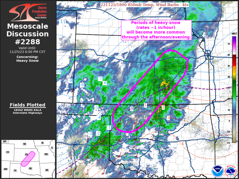
MD 2288 CONCERNING HEAVY SNOW FOR NORTHWEST OKLAHOMA TO CENTRAL KANSAS

Mesoscale Discussion 2288 NWS Storm Prediction Center Norman OK 1258 PM CST Sat Nov 25 2023 Areas affected...Northwest Oklahoma to central Kansas Concerning...Heavy snow Valid 251858Z - 260000Z SUMMARY...The potential for periods of heavy snow (snowfall rates exceeding 1 inch/hour) will steadily increase through the afternoon and early evening hours across northwest OK and southern to central KS. DISCUSSION...Over the past hour, a few surface observations across south-central KS have reported periods of visibility reductions down to 0.25 mile, indicative of heavy snowfall rates. Such conditions are expected to become more common through the remainder of the afternoon and early evening hours. Latest water-vapor imagery shows the exit region of the 500 mb jet overspreading the TX/OK Panhandles region; concurrently, regional VWP observations have sampled strengthening flow in the 1-2 km layer - likely a mass response associated with the approaching jet. Consequently, both synoptic and mesoscale ascent (isentropic and frontogenetical lift within a warm advection regime near 850 mb) appear to be increasing over the region. Upstream radar trends support this idea with a gradually expanding swath of stratiform precipitation noted over the eastern TX Panhandle. This lift/precipitation will shift east through the afternoon and evening hours, resulting in gradual change over to primarily snow across parts of northwest OK as well as a prolonged period of moderate snowfall rates across southern KS. Strong mesoscale ascent along the 850 mb baroclinic zone, coupled with weak (< 50 J/kg MUCAPE) buoyancy, should result in periods of heavy snowfall with rates approaching 1 inch/hour. ..Moore.. 11/25/2023 ...Please see www.spc.noaa.gov for graphic product... ATTN...WFO...TOP...ICT...OUN...DDC... LAT...LON 38279599 36179817 35939855 35819888 35839930 35939963 36249984 36529987 36809976 39229712 39379682 39329640 38939575 38619580 38279599Read more -
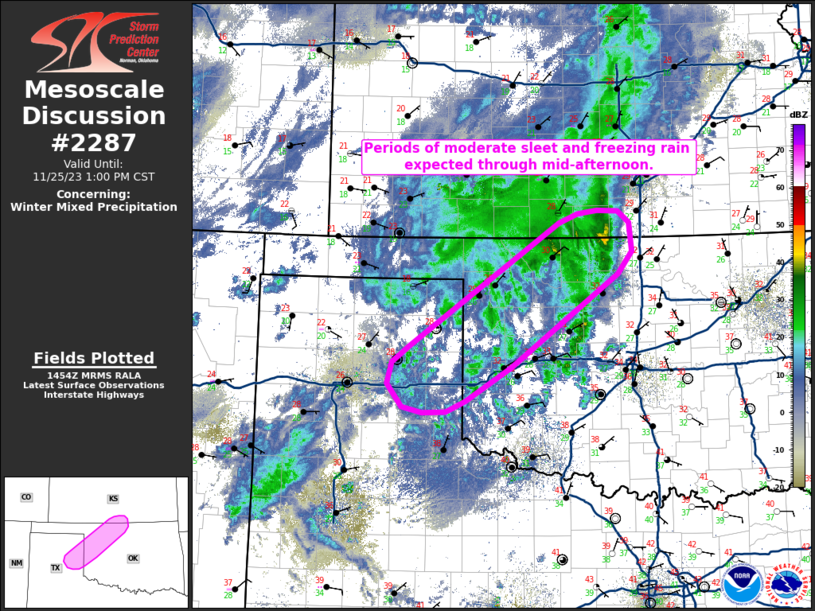
MD 2287 CONCERNING WINTER MIXED PRECIPITATION FOR EASTERN TEXAS PANHANDLE INTO NORTHWEST OKLAHOMA
Mesoscale Discussion 2287 NWS Storm Prediction Center Norman OK 0855 AM CST Sat Nov 25 2023 Areas affected...Eastern Texas Panhandle into northwest Oklahoma Concerning...Winter mixed precipitation Valid 251455Z - 251900Z SUMMARY...Periods of moderate sleet and freezing rain appear probable through mid-afternoon across the eastern Texas Panhandle and northwest Oklahoma. Freezing rain rates up to 0.1 in/hour are possible. DISCUSSION...Surface observations and mPING reports over the past hour are reporting a wintry mix of sleet and freezing rain ongoing from the I-40 corridor in the eastern TX Panhandle into northwest OK. Despite temperatures well below freezing across the region, correlation coefficient data from KVNX suggests a melting layer remains in place at around 4 kft, or roughly at the 800 mb level. These observations lend credence to recent RAP forecast soundings, which suggest that this 1-2 C warm layer will remain in place through mid-afternoon. Other 12z guidance also suggests a mix of sleet and freezing rain will persist through at least early afternoon with some solutions hinting at periods of freezing rain accumulations up to 0.1 in/hour (though this will be conditional on realizing freezing rain as the predominant precipitation type, which remains uncertain based on latest obs). Regardless, the approach of the main synoptic wave and attendant upper jet, coupled with a persistent warm advection regime at around 850-800 mb, should favor additional wintry precip through the afternoon. 700-500 mb lapse rates near 7 C/km could support weak (< 50 J/kg) MUCAPE, resulting in embedded areas of moderate freezing rain/sleet rates. ..Moore.. 11/25/2023 ...Please see www.spc.noaa.gov for graphic product... ATTN...WFO...ICT...OUN...DDC...AMA... LAT...LON 35490104 35680079 37189856 37289827 37329799 37319767 37179751 36829747 36559768 35439928 35029995 34890025 34870059 34950090 35230111 35490104Read more -
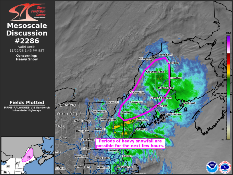
MD 2286 CONCERNING HEAVY SNOW FOR NORTHERN MAINE AND NORTHEASTERN NEW HAMPSHIRE
Mesoscale Discussion 2286 NWS Storm Prediction Center Norman OK 0850 AM CST Wed Nov 22 2023 Areas affected...northern Maine and northeastern New Hampshire Concerning...Heavy snow Valid 221450Z - 221845Z SUMMARY...Periods of heavy snowfall, with rates up to 1-1.5 inches per hour, are possible for the next few hours across northern Maine and northeastern New Hampshire. DISCUSSION...Heavy snowfall rates have been observed this morning across portions of northern Maine. This activity is associated with a surface cyclone currently analyzed along the southern New England coast. The cyclone should continue to gradually deepen throughout the morning due to differential cyclonic vorticity advection (ahead of a mid-level shortwave trough) and low-level coastal baroclinity as it moves east-northeastward. 12z GYX/CAR soundings exhibited strong veering in the lowest ~3 km AGL, indicative of widespread low-level warm-air advection. Temperatures aloft in the lowest 3 km AGL are nearly isothermal and below freezing, except nearer to the coast where surface temperatures rising into the 40s F are observed. Farther inland, the continued northward moisture flux atop colder surface conditions could contribute to periods of heavy snowfall (1-1.5 inches per hour) for the next few hours. ..Flournoy.. 11/22/2023 ...Please see www.spc.noaa.gov for graphic product... ATTN...WFO...CAR...GYX... LAT...LON 44307029 44606929 45106840 45656787 46916786 47196816 47096881 46596959 45767021 45257067 44887117 44427133 44177094 44307029Read more -
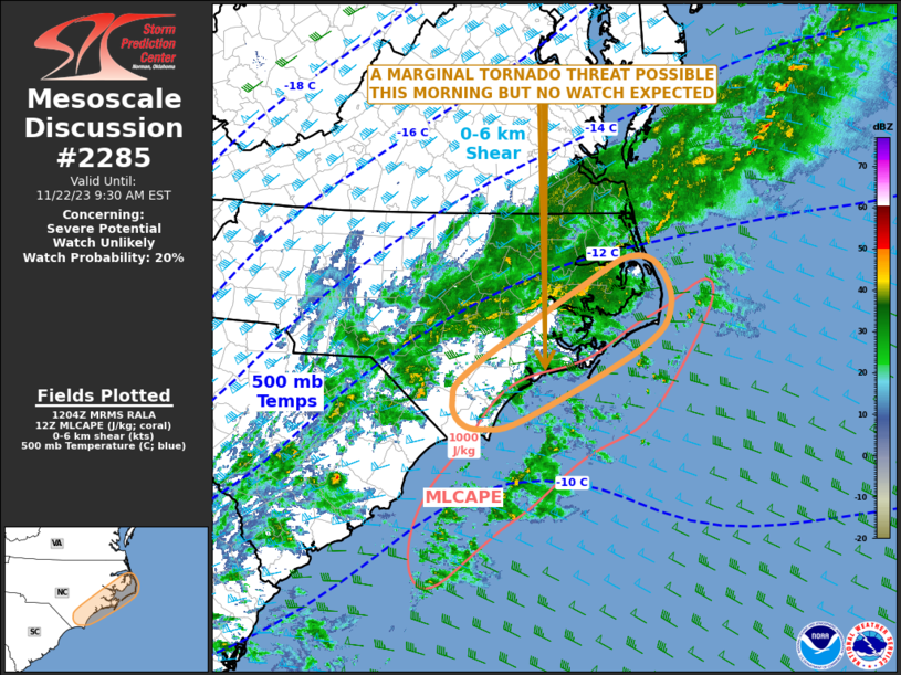
MD 2285 CONCERNING SEVERE POTENTIAL...WATCH UNLIKELY FOR EASTERN NORTH CAROLINA
Mesoscale Discussion 2285 NWS Storm Prediction Center Norman OK 0607 AM CST Wed Nov 22 2023 Areas affected...Eastern North Carolina Concerning...Severe potential...Watch unlikely Valid 221207Z - 221430Z Probability of Watch Issuance...20 percent SUMMARY...An isolated tornado threat is expected to develop across parts of eastern North Carolina this morning. The severe threat should remain marginal, and weather watch issuance is not expected. DISCUSSION...At mid-levels, a trough and an associated speed max, are located over the central Gulf Coast states. The 80 to 100 knot mid-level jet will continue to approach the Carolinas over the next few hours. As a result, large-scale ascent and deep-layer shear will gradually strengthen over the Carolinas this morning. At the surface, a mesoscale low is analyzed over northeastern South Carolina, with another in northeastern North Carolina. A weakly unstable airmass is present to the east of this surface trough. This airmass will slowly destabilize this morning, which will make conditions more favorable for rotating storms. In addition, the WSR-88D VWP near Wilmington, North Carolina currently has 0-3 km storm-relative helicity near 230 m2/s2. As the low-level shear strengthens ahead of the system, a marginal tornado threat is expected to develop. This threat should persist throughout the morning from near the coast of North Carolina inland about 50 statute miles. ..Broyles/Edwards.. 11/22/2023 ...Please see www.spc.noaa.gov for graphic product... ATTN...WFO...MHX...RAH...ILM... LAT...LON 34957572 34107744 33967803 34057837 34317849 34677823 35747652 36047591 35927550 35447533 34957572Read more -
MD 2283 CONCERNING SEVERE POTENTIAL...WATCH UNLIKELY FOR FAR SOUTHEAST ALABAMA...SOUTHWEST GEORGIA...FLORIDA PANHANDLE
Mesoscale Discussion 2283 NWS Storm Prediction Center Norman OK 0526 PM CST Tue Nov 21 2023 Areas affected...far southeast Alabama...southwest Georgia...Florida Panhandle Concerning...Severe potential...Watch unlikely Valid 212326Z - 220200Z Probability of Watch Issuance...20 percent SUMMARY...The risk for an isolated, brief tornado may persist for another 2 hours or so, from parts of southeast Alabama into southwest Georgia. Given the short time frame and areal extent of the threat, a watch is not expected. DISCUSSION...An isolated supercell is currently ongoing over far southeast AL, just ahead of a line of storms along a cold front. The air mass ahead of the front is reasonably unstable to support severe storms given the shear, but overall large-scale support is dwindling as the low-level jet shifts northeastward. In the short term, sufficient instability of 500-1000 J/kg and 0-1 SRH of 150-180 m2/s2 may sustain a localized supercell/tornado risk, with ongoing activity, with a relatively limited threat corridor along and east of the cold front. ..Jewell/Guyer.. 11/21/2023 ...Please see www.spc.noaa.gov for graphic product... ATTN...WFO...FFC...TAE...BMX... LAT...LON 30998608 31468575 32018514 32438451 32548387 32298346 31828348 31098405 30758473 30668533 30798587 30788604 30998608Read more -
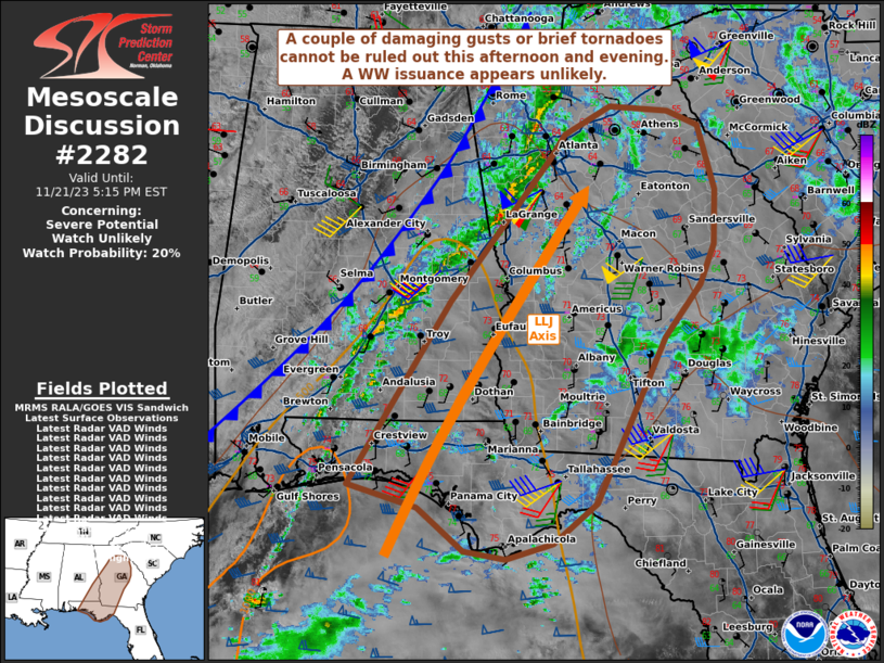
MD 2282 CONCERNING SEVERE POTENTIAL...WATCH UNLIKELY FOR PORTIONS OF EASTERN ALABAMA INTO WESTERN GEORGIA AND THE WESTERN FLORIDA PANHANDLE
Mesoscale Discussion 2282 NWS Storm Prediction Center Norman OK 0152 PM CST Tue Nov 21 2023 Areas affected...portions of eastern Alabama into western Georgia and the western Florida Panhandle Concerning...Severe potential...Watch unlikely Valid 211952Z - 212215Z Probability of Watch Issuance...20 percent SUMMARY...A couple of damaging gusts or brief tornadoes cannot be ruled out with any of the stronger storms that can materialize this afternoon into early evening. The severe threat will likely be isolated. DISCUSSION...Convection is slowly deepening along a line immediately ahead of a surface cold front that progressing eastward across central AL. Limited diurnal heating amid low-level warm-air advection has allowed for scant buoyancy to develop ahead of the aforementioned convective line. Surface temperatures warming into the low to mid 70s F amid mid 60s F dewpoints beneath poor tropospheric lapse rates supports narrow SBCAPE profiles (mainly below 500 J/kg), with evidence of embedded thin inversion layers (per latest RAP forecast soundings). While a strong low-level jet is in place (contributing to enlarged, curved hodographs), the surface low over the OH Valley should continue to drift northeastward with time, supporting an eastward shift of the low-level jet and resultant veering of flow in the surface-850 mb layer. When also considering the scant buoyancy, the severe threat appears limited. Nonetheless, there may be a window of opportunity for some of the stronger convective cells embedded in the line to overlap with locally higher CAPE before low-level flow veers and hodographs lose their curvature. For a few hours during the afternoon, some of these storms may acquire brief/transient low-level rotation. As such, a couple of damaging gusts or brief tornadoes cannot be completely ruled out. Nonetheless, the anticipated isolated nature of the severe threat suggests that a WW issuance will probably not be needed later today. ..Squitieri/Gleason.. 11/21/2023 ...Please see www.spc.noaa.gov for graphic product... ATTN...WFO...CAE...GSP...FFC...TAE...BMX...MOB... LAT...LON 30348686 32228565 33688445 33938428 34228372 34168303 34018266 33358246 32798247 32388265 31848308 30738362 30158390 29758442 29598498 29678548 30038594 30108602 30348686Read more -
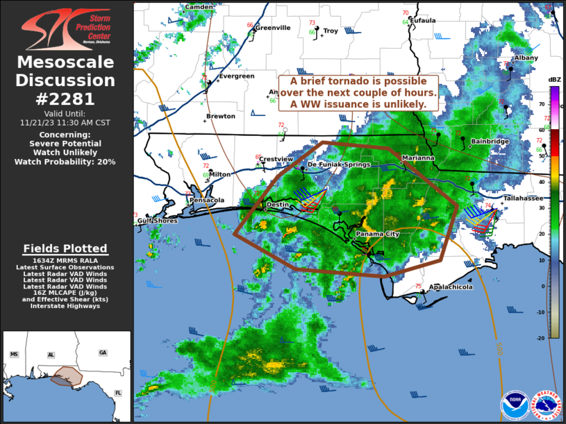
MD 2281 CONCERNING SEVERE POTENTIAL...WATCH UNLIKELY FOR PORTIONS OF THE FLORIDA PANHANDLE
Mesoscale Discussion 2281 NWS Storm Prediction Center Norman OK 1036 AM CST Tue Nov 21 2023 Areas affected...portions of the Florida Panhandle Concerning...Severe potential...Watch unlikely Valid 211636Z - 211730Z Probability of Watch Issuance...20 percent SUMMARY...A brief tornado or two may accompany low-topped supercells as they approach the FL Panhandle shoreline. The severe threat should stay isolated over the next couple of hours, so a WW issuance is not expected in the near-term. DISCUSSION...Low-topped supercells have developed within the low-level warm-air-advection axis and are approaching the western FL Panhandle. Along the coast, strong veering and strengthening of the low-level wind profile supports enlarged hodographs. While dewpoints are reaching 70 F along the coast, weak diurnal heating beneath poor tropospheric lapse rates are resulting in thin CAPE profiles (with SBCAPE struggling to exceed 500 J/kg). As such, the strong low-level shear may support a brief tornado across the western FL Panhandle, but the severe threat should remain sparse at best over the next couple of hours, and a WW issuance not anticipated. Should more appreciable surface heating occur through the afternoon ahead of an approaching cold front, a relatively more robust severe threat could materialize. The region will be monitored more carefully for such a scenario and the need for a WW issuance later today. ..Squitieri/Gleason.. 11/21/2023 ...Please see www.spc.noaa.gov for graphic product... ATTN...WFO...TAE...MOB... LAT...LON 30188678 30668638 30938595 30888533 30428470 29988485 29848538 29908620 30188678Read more -
MD 2280 CONCERNING SEVERE POTENTIAL...WATCH POSSIBLE FOR SOUTHERN MISSISSIPPI INTO PARTS OF EASTERN LOUISIANA
Mesoscale Discussion 2280 NWS Storm Prediction Center Norman OK 1153 PM CST Mon Nov 20 2023 Areas affected...southern Mississippi into parts of eastern Louisiana Concerning...Severe potential...Watch possible Valid 210553Z - 210730Z Probability of Watch Issuance...40 percent SUMMARY...A few strong may produce strong gusts or even a brief tornado, but the overall threat in the near term is not expected to warrant an additional watch. DISCUSSION...Storms have aggregated into a broken line from southern MS into southeast LA, with indications of gusts winds at times. Little rotation or supercell structures have been observed in the past hour, likely due to gradually veering low-level winds and decreasing ascent overall. Effective SRH around 300 m2/s2, a moist boundary layer and 500-1000 J/kg MLCAPE still may yield a supercell, but perhaps short lived, with brief tornado potential. However, the overall threat does not appear high enough for an additional tornado watch at this time. Given the moist air mass and 40-50 kt low-level jet, convective trends will continue to be monitored for any increase in intensity overnight. ..Jewell.. 11/21/2023 ...Please see www.spc.noaa.gov for graphic product... ATTN...WFO...MOB...JAN...LIX...LCH... LAT...LON 29729121 29909118 30809039 31518967 31848942 32058893 32018860 31778833 31338816 30998826 30558861 29958960 29759061 29739114 29729121Read more -
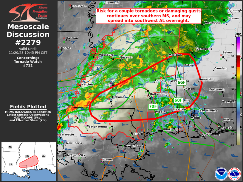
MD 2279 CONCERNING TORNADO WATCH 712... FOR SOUTHERN MISSISSIPPI INTO SOUTHWEST ALABAMA
Mesoscale Discussion 2279 NWS Storm Prediction Center Norman OK 0847 PM CST Mon Nov 20 2023 Areas affected...southern Mississippi into southwest Alabama Concerning...Tornado Watch 712... Valid 210247Z - 210445Z The severe weather threat for Tornado Watch 712 continues. SUMMARY...A tornado or two remains possible this evening over southern Mississippi, with a few damaging gusts possible as well. The severe risk may eventually spread into parts of southwest Alabama later tonight. DISCUSSION...A broken line of storms including a few supercells currently stretch east-central MS southwestward into southwest LA. Deep-layer shear remain favorable to sustain cells this evening, with effective SRH maximized over central MS currently. Persistent southerly winds in the lower 2 km will continue to aid moisture advection, with upper 60s F dewpoints spreading north across southwest AL ahead of the ongoing MS storms. A somewhat stable air mass exists east of a batch of warm advection showers now forming over southwest AL, and this general zone may be as far east as the main severe risk gets tonight. As cells continue east across MS and approach the AL state line, additional watches may be considered. ..Jewell.. 11/21/2023 ...Please see www.spc.noaa.gov for graphic product... ATTN...WFO...BMX...MOB...JAN...LIX... LAT...LON 31389080 31788989 32128918 32448848 32428803 32258787 31668765 31318778 31048803 30738909 30669006 30669082 30809105 30979112 31139108 31389080Read more -
MD 2278 CONCERNING TORNADO WATCH 712... FOR MUCH OF CENTRAL MISSISSIPPI
Mesoscale Discussion 2278 NWS Storm Prediction Center Norman OK 0603 PM CST Mon Nov 20 2023 Areas affected...much of central Mississippi Concerning...Tornado Watch 712... Valid 210003Z - 210130Z The severe weather threat for Tornado Watch 712 continues. SUMMARY...The risk for tornadoes appears highest over the next couple hours over south-central Mississippi. DISCUSSION...Large clusters of storms including supercells continue to rapidly move east into central MS, with the strongest supercell over southwest MS. This area has the most favorable environment for a strong tornado, with dewpoints rising to near 70 F, and 0-1 SRH > 200 m2/s2. Indeed, surface winds ahead of this particular supercell cluster remain backed with strong gusts, indicating increased pressure falls and potential strengthening with these storms. Gusting winds also indicate the boundary layer is favorably unstable, which will allow supercells to utilize the full low-level shear available. ..Jewell.. 11/21/2023 ...Please see www.spc.noaa.gov for graphic product... ATTN...WFO...MOB...JAN...LIX... LAT...LON 31438870 31338887 31268922 31188991 31229120 31469133 31609109 31889061 32099029 32348996 32778974 32748916 32528885 32038860 31528860 31438870Read more -
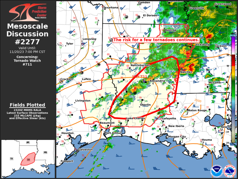
MD 2277 CONCERNING TORNADO WATCH 711... FOR PORTIONS OF CENTRAL AND EASTERN LOUISIANA
Mesoscale Discussion 2277 NWS Storm Prediction Center Norman OK 0523 PM CST Mon Nov 20 2023 Areas affected...portions of central and eastern Louisiana Concerning...Tornado Watch 711... Valid 202323Z - 210100Z The severe weather threat for Tornado Watch 711 continues. SUMMARY...Ongoing severe storms will continue to pose a risk for a few tornadoes across WW711 this evening. DISCUSSION...Across parts of central LA, a band of convection has shown slow maturation with a couple of supercells becoming established from the broader convection over the last couple of hour. Ongoing within a moist, and unstable environment, conditions look favorable for these storms to maintain intensity this evening. Strong mid and upper-level shear will continue to favor organized storms including supercells and short line segments. While surface winds have veered slightly this afternoon, low-level hodographs remain long and supportive of strong low-level mesocyclones. Low-level shear should increase to the east beneath a southwesterly low-level jet. As storms mature they should remain capable of a few tornadoes and damaging gusts across central and eastern LA this evening. ..Lyons.. 11/20/2023 ...Please see www.spc.noaa.gov for graphic product... ATTN...WFO...JAN...LIX...LCH...SHV... LAT...LON 30269317 30289358 30389379 30809361 31389301 31829247 32069165 31999149 31689140 30769158 30599187 30309274 30269317Read more -
MD 2276 CONCERNING SEVERE POTENTIAL...WATCH LIKELY FOR CENTRAL/SOUTHWEST MS...SOUTHEAST LA
Mesoscale Discussion 2276 NWS Storm Prediction Center Norman OK 0314 PM CST Mon Nov 20 2023 Areas affected...Central/Southwest MS...Southeast LA Concerning...Severe potential...Watch likely Valid 202114Z - 202315Z Probability of Watch Issuance...80 percent SUMMARY...Threat for severe thunderstorms capable of all severe hazards, including tornadoes, will continue eastward into central and southeast Mississippi and southeast Louisiana later this afternoon and evening. DISCUSSION...Thunderstorms, including several supercells, continue to evolve eastward over southeast TX and LA, ahead of an approaching upper-level trough and associated cold front. Modest destabilization has occurred within the downstream air mass from west-central MS into southeast LA. This region is displaced north and east of the better low-level moisture over southwest LA, but a large area of mid to upper 60s dewpoints exists across south-central and southeast LA. This should continue to advect northeastward ahead of the approaching upper trough, contributing to further destabilization over the next few hours. Low-level flow is also expected to increase ahead of this upper trough, with the resulting combination of buoyancy and shear contributing to a continued threat for severe thunderstorms this evening. Given the strong shear, primary severe risk is tornadoes, a few of which could be strong, with some threat for damaging gusts and/or isolated hail as well. A watch will likely be needed within the next hour or two to address this severe potential. ..Mosier/Gleason.. 11/20/2023 ...Please see www.spc.noaa.gov for graphic product... ATTN...WFO...MOB...JAN...LIX... LAT...LON 31989122 32789080 32969009 32868950 32648917 32308896 32018889 31728901 31068930 30578977 30379056 30429140 30809168 31989122Read more -
MD 2275 CONCERNING SEVERE POTENTIAL...WATCH UNLIKELY FOR SOUTHEAST OKLAHOMA AND FAR NORTHEAST TEXAS.
Mesoscale Discussion 2275 NWS Storm Prediction Center Norman OK 0258 PM CST Mon Nov 20 2023 Areas affected...southeast Oklahoma and far northeast Texas. Concerning...Severe potential...Watch unlikely Valid 202058Z - 202200Z Probability of Watch Issuance...5 percent SUMMARY...Isolated large hail possible this afternoon across southeast Oklahoma and far northeast Texas. DISCUSSION...A pocket of destabilization has occurred near a surface low in southeast Oklahoma where temperatures have warmed into the upper 70s with dewpoints in the mid to upper 50s. Low-level convergence associated with this surface low, combined with cool temperatures aloft and and the aforementioned instability has provided an environment favorable for scattered storm development this afternoon. Very strong mid-upper level flow is supporting rotating updrafts. Therefore, a few of these cells may be capable of isolated large hail for the next few hours. This threat will persist for a few hours and wane after sunset with the loss of daytime heating. ..Bentley/Gleason.. 11/20/2023 ...Please see www.spc.noaa.gov for graphic product... ATTN...WFO...LZK...SHV...TSA...FWD...OUN... LAT...LON 33679530 33869643 34069668 34209674 34659654 35029607 35109531 34849459 33939438 33639446 33599470 33679530Read more -
MD 2274 CONCERNING TORNADO WATCH 711... FOR SOUTHEAST TX...MUCH OF LA
Mesoscale Discussion 2274 NWS Storm Prediction Center Norman OK 0235 PM CST Mon Nov 20 2023 Areas affected...Southeast TX...Much of LA Concerning...Tornado Watch 711... Valid 202035Z - 202200Z The severe weather threat for Tornado Watch 711 continues. SUMMARY...Threat for supercells capable of all severe hazards, including strong tornadoes, continues. Greatest near-term tornado threat exists from far southeast Texas through west-central and central Louisiana. DISCUSSION...Recent surface analysis reveals a complex pattern with several different boundaries in place across far southeast TX and LA this afternoon. Thunderstorms have been increasing along an axis of pre-frontal convergence that exists just of ahead of the eastward-progressing cold front. This pre-frontal trough exists roughly from the central LA/TX border (about 40 miles southwest of SHV) south-southwestward through Liberty County TX. Environment ahead of this trough continues to destabilize amid low-level moisture advection, with 70 deg F dewpoints in place ahead of this axis across southeast TX and southwest LA. This area of greater low-level moisture is advecting northward, coincident with strengthening low-level flow. This strengthening low-level flow is contributing to longer low-level hodographs and greater storm-relative helicity. As such, an increase in tornadic supercells appears possible over the next hour or two, particularly from Jasper County TX northeastward into west-central/central LA. ..Mosier.. 11/20/2023 ...Please see www.spc.noaa.gov for graphic product... ATTN...WFO...LCH...SHV...HGX... LAT...LON 30059255 29829313 29789387 30049456 30529464 31499420 32119397 32519324 32469247 32279218 31889206 31399201 30509230 30059255Read more -
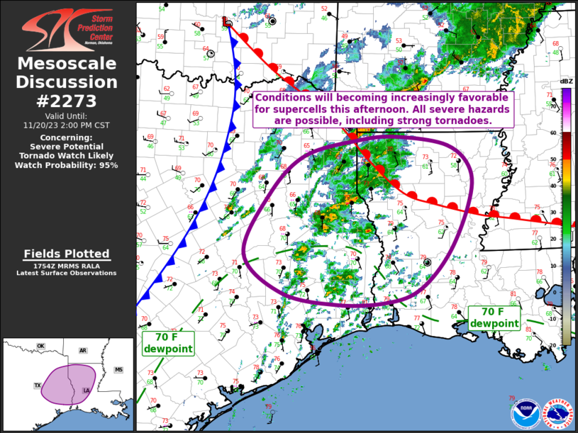
MD 2273 CONCERNING SEVERE POTENTIAL...TORNADO WATCH LIKELY FOR EAST/SOUTHEAST TX...MUCH OF LA
Mesoscale Discussion 2273 NWS Storm Prediction Center Norman OK 1156 AM CST Mon Nov 20 2023 Areas affected...East/Southeast TX...Much of LA Concerning...Severe potential...Tornado Watch likely Valid 201756Z - 202000Z Probability of Watch Issuance...95 percent SUMMARY...A Tornado Watch is expected this afternoon from east/southeast Texas into much of Louisiana, where the potential for tornadoes, some of which could be strong, exists. DISCUSSION...Recent surface analysis places a low over south-central OK, with a cold front extending southward through central TX and then more southwestward into the TX Hill Country. A warm front also extends southeastward from this low to SHV, stretching more east-southeastward from there across central LA into southwest MS. Showers and isolated thunderstorms are ongoing within the warm sector, supported by ample low-level moisture and warm-air advection within the warm conveyor. Several attempts at more sustained thunderstorm development have occurred farther west along the cold front, but none have been successful thus far. A somewhat complex convective scenario is expected to play out from east/southeast TX into central LA this afternoon. Favorable low-level moisture will continue to advect northward ahead of the approaching cold front (and parent upper-level trough), contributing to air mass destabilization. Southerly/southwesterly low-level flow will increase this afternoon as well, strengthening low-level shear within an environment that already has favorable deep-layer shear. The result will be an environment supportive of supercells whenever updrafts mature. This maturation may initially be stunted by limited buoyancy, but continued low-level moisture advection should allow for this limitation to be overcome by the late afternoon. A corridor of moderate buoyancy is expected from east-central TX into central LA. Supercells capable of all severe hazards, including tornadoes are anticipated. Shear profiles suggest the potential for a strong tornado exists, particularly near the warm front, if a more discrete mode can be maintained. Given this potential, a Tornado Watch will be needed across portions of the area this afternoon. ..Mosier/Gleason.. 11/20/2023 ...Please see www.spc.noaa.gov for graphic product... ATTN...WFO...JAN...LCH...SHV...HGX...FWD... LAT...LON 30949625 31959576 32609508 32889401 32939325 32789224 32379180 31789184 30949224 30359283 30149348 30119441 30299549 30949625Read more -
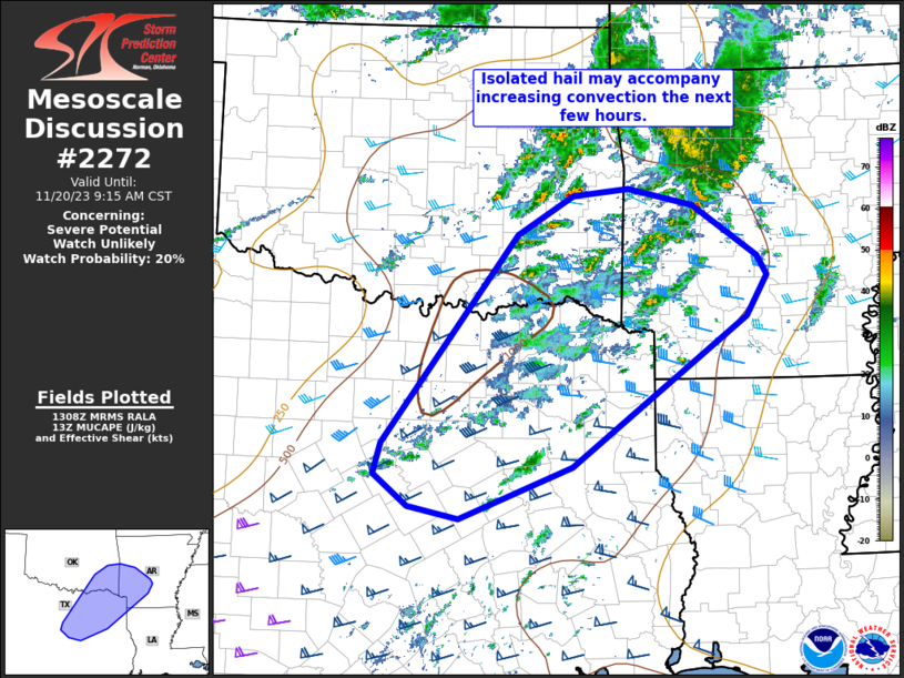
MD 2272 CONCERNING SEVERE POTENTIAL...WATCH UNLIKELY FOR PORTIONS OF NORTH TX...SOUTHEAST OK...AND SOUTHWEST AR
Mesoscale Discussion 2272 NWS Storm Prediction Center Norman OK 0711 AM CST Mon Nov 20 2023 Areas affected...portions of north TX...southeast OK...and southwest AR Concerning...Severe potential...Watch unlikely Valid 201311Z - 201515Z Probability of Watch Issuance...20 percent SUMMARY...Isolated hail around a half inch to near one inch in diameter is possible the next few hours. DISCUSSION...A deepening field of altocumulus is evident in IR imagery this morning across north TX. Based on 12z FWD RAOB, these clouds are likely rooted around 600 mb. This indicates increasing ascent associated with the approaching upper trough is spreading east, and aiding in modest growth over the past hour. Regional 12z RAOBs still indicate quite a bit of low-level inhibition, with layers of dry air above shallow boundary-layer moisture. Moistening and heating through mid to late morning will continue to improve the thermodynamic environment, while large-scale ascent erodes capping. In the short term, steepening midlevel lapse rates and favorable vertical shear may support transient strong cells capable of marginally severe hail through around 16z. A severe thunderstorm watch is not expected at this time, as initial convection is expected to only slowly increase in intensity the next few hours, but trends will be monitored closely. ..Leitman/Edwards.. 11/20/2023 ...Please see www.spc.noaa.gov for graphic product... ATTN...WFO...LZK...SHV...TSA...FWD...OUN... LAT...LON 34179250 33729279 32029513 31449665 31579733 31939779 32289768 34649587 35089512 35169438 34989351 34409263 34179250Read more -
No Mesoscale Discussions are in effect as of Mon Nov 20 08:31:01 UTC 2023.
-
Winter Weather Preparedness Week 2023
-
No Mesoscale Discussions are in effect as of Wed Nov 15 23:31:02 UTC 2023.
-
MD 2270 CONCERNING SEVERE POTENTIAL...WATCH UNLIKELY FOR THE FLORIDA KEYS
Mesoscale Discussion 2270 NWS Storm Prediction Center Norman OK 0302 PM CST Wed Nov 15 2023 Areas affected...the Florida Keys Concerning...Severe potential...Watch unlikely Valid 152102Z - 152330Z Probability of Watch Issuance...20 percent SUMMARY...An isolated tornado/tornadic waterspout threat continues across the Florida Keys area. Given the sparse and spatially confined nature of the severe threat, a WW issuance is not expected. DISCUSSION...Strong thunderstorms, with several showing brief bouts of low-level rotation, continue along and just south of the FL Keys in proximity to a quasi-stationary surface boundary. To the southwest of Key West, a small bow-echo signature continues to surge quickly to the southeast with strong gust potential, and may overturn the airmass/reduce instability along its way. Ahead of this bow-echo feature, an MCV has materialized along and just north of the aforementioned surface boundary and is likely benefiting from locally stronger low-level shear. Semi-discrete cells within and ahead of this MCV may encounter locally backed low-level winds/enlarged hodographs, and an isolated supercellular/tornadic waterspout remains possible with any of the stronger storms. ..Squitieri.. 11/15/2023 ...Please see www.spc.noaa.gov for graphic product... ATTN...WFO...MFL...KEY... LAT...LON 24458230 24958151 25228075 25427983 25307945 24877935 24417951 24108018 23998159 24028170 24458230Read more -
MD 2269 CONCERNING SEVERE POTENTIAL...WATCH UNLIKELY FOR PORTIONS OF THE FLORIDA KEYS
Mesoscale Discussion 2269 NWS Storm Prediction Center Norman OK 1151 AM CST Wed Nov 15 2023 Areas affected...portions of the Florida Keys Concerning...Severe potential...Watch unlikely Valid 151751Z - 152015Z Probability of Watch Issuance...5 percent SUMMARY...A brief tornado/waterspout is possible over the Florida Keys over the next few hours. A WW issuance is not expected. DISCUSSION...Thunderstorms have been percolating in intensity over the past few hours around the FL Keys, some of which have shown occasional instances of transient low-level rotation. Mid-level lapse rates remain poor over the region. However, the combination of surface heating amid mid 70s F surface dewpoints should support 500-1000 J/kg of tall and thin SBCAPE through the afternoon. Coinciding the buoyancy axis should be increasing 850 mb flow, which would support modestly curved low-level hodographs. As such, the stronger, more persistent thunderstorms should continue to exhibit at least brief periods of low-level rotation and a tornado (or tornadic waterspout) remains possible around the FL Keys through the afternoon hours. The tornado threat however is quite sparse, so a Tornado Watch issuance is not anticipated. ..Squitieri/Mosier.. 11/15/2023 ...Please see www.spc.noaa.gov for graphic product... ATTN...WFO...MFL...KEY... LAT...LON 24518228 24678194 25028114 25218054 25158027 24908019 24588039 24378086 24348145 24358194 24518228Read more -
No Mesoscale Discussions are in effect as of Thu Nov 9 12:01:02 UTC 2023.
-
No Mesoscale Discussions are in effect as of Sat Oct 28 18:16:02 UTC 2023.


SPC MD 2289
in Storm Prediction Center RSS Feed
Posted
Mesoscale Discussion 2289
NWS Storm Prediction Center Norman OK
0116 AM CST Tue Nov 28 2023

Areas affected...Western NY...Extreme Northwest PA...Far Northeast
OH

Concerning...Heavy snow

Valid 280716Z - 281115Z

SUMMARY...Heavy snowfall, with rates over 2" per hour, are possible
across the Tug Hill Plateau over the next several hours. Moderate to
occasionally heavy snowfall is also anticipated farther south in the
immediate lee of Lake Erie.

DISCUSSION...Recent radar imagery continues to show a loosely
organized band of heavy snowfall extending from eastern portions of
Lake Ontario eastward through Oswego, southern Jefferson, and Lewis
Counties. Overall organization of this band is expected to improve
over the next several hours as broad westerly flow across the lake
persists, and local convergence increases due to strengthening and
veering of the winds south of the lake. Some strengthening is
possible with the winds over the lake as well as the more
west-northwesterly winds north of the lake. Snowfall rates from 1"
to 2" per hour will continue for the next several hours, likely
maximizing in the 08Z-10Z time frame, when rates of 2" per hour are
most likely.

Farther south, a shorter lake fetch is contributing to a broad areas
of moderate snowfall in the lee of Lake Erie. Less low-level
convergence and weaker band organization should keep snowfall rates
a bit lower here than areas farther north, with rates generally
expected to maximize around 1" per hour.

..Mosier.. 11/28/2023

...Please see www.spc.noaa.gov for graphic product...

ATTN...WFO...BGM...BUF...CTP...CLE...

LAT...LON   43587694 43987619 44157546 43557530 42217781 41548055
            41388156 41968137 42697907 43587694
Read moreView the full article