


NorthGeorgiaWX
-
Posts
34,600 -
Joined
-
Last visited
-
Days Won
1,500
Content Type
Profiles
Blogs
Forums
Gallery
Events
Store
Downloads
Posts posted by NorthGeorgiaWX
-
-
No watches are valid as of Mon Dec 11 02:09:02 UTC 2023.
-
Special Weather Statement issued December 10 at 9:08PM EST by NWS
-
Special Weather Statement issued December 10 at 9:01PM EST by NWS
-
SPC 0100Z Day 1 Outlook

Day 1 Convective Outlook
NWS Storm Prediction Center Norman OK
0654 PM CST Sun Dec 10 2023

Valid 110100Z - 111200Z

...THERE IS A MARGINAL RISK OF SEVERE THUNDERSTORMS ACROSS FAR
EASTERN NORTH CAROLINA...

...SUMMARY...
A marginal tornado threat is expected to continue this evening near
Cape Hatteras. Elsewhere across the continental United States, a
severe threat is not expected.

...Far Eastern North Carolina...
At the surface, a cold front is currently located in western North
Carolina, in the vicinity of Greensboro and Charlotte. Thunderstorms
are ongoing well to the east of the front across eastern North
Carolina, where surface dewpoints are in the mid 60s F. In addition,
the Morehead City WSR-88D VWP has 0-3 km storm-relative helicity
near 400 m2/s2. This suggests that a marginal tornado threat should
continue this evening, as storms move northeastward across the Outer
Banks. The tornado potential will be minimal, and is expected to
gradually diminish as the cold front approaches the coast later
tonight.

..Broyles.. 12/11/2023
Read more -
Special Weather Statement issued December 10 at 7:56PM EST by NWS
-
WW 0721 Status Updates
STATUS REPORT ON WW 721

SEVERE WEATHER THREAT CONTINUES RIGHT OF A LINE FROM 15 S EWN TO
35 SSW ECG TO 30 ENE RZZ TO 30 ESE RIC.

..SPC..12/10/23

ATTN...WFO...MHX...AKQ...RAH...


STATUS REPORT FOR WT 721

SEVERE WEATHER THREAT CONTINUES FOR THE FOLLOWING AREAS

NCC029-031-041-053-055-073-095-139-143-110040-

NC
.    NORTH CAROLINA COUNTIES INCLUDED ARE

CAMDEN               CARTERET            CHOWAN
CURRITUCK            DARE                GATES
HYDE                 PASQUOTANK          PERQUIMANS


VAC073-093-095-175-181-199-550-620-650-700-710-735-740-800-810-
830-110040-

VA
.    VIRGINIA COUNTIES INCLUDED ARE

GLOUCESTER           ISLE OF WIGHT       JAMES CITY
SOUTHAMPTON          SURRY               YORK


VIRGINIA INDEPENDENT CITIES INCLUDED ARE

CHESAPEAKE           FRANKLIN            HAMPTON
Read more -
WW 721 TORNADO NC VA CW 101830Z - 110100Z
URGENT - IMMEDIATE BROADCAST REQUESTED
Tornado Watch Number 721
NWS Storm Prediction Center Norman OK
130 PM EST Sun Dec 10 2023

The NWS Storm Prediction Center has issued a

* Tornado Watch for portions of
  Central and Eastern North Carolina
  Southeast Virginia
  Coastal Waters

* Effective this Sunday afternoon and evening from 130 PM until
  800 PM EST.

* Primary threats include...
  A couple tornadoes possible
  Isolated damaging wind gusts to 65 mph possible

SUMMARY...A moist environment and stronger deep-layer/low-level
winds will support a long duration (into this evening) of at least
isolated severe storm potential, including a risk for tornadoes and
damaging winds.

The tornado watch area is approximately along and 80 statute miles
east and west of a line from 45 miles northwest of Norfolk VA to 20
miles west of Jacksonville NC. For a complete depiction of the watch
see the associated watch outline update (WOUS64 KWNS WOU1).

PRECAUTIONARY/PREPAREDNESS ACTIONS...

REMEMBER...A Tornado Watch means conditions are favorable for
tornadoes and severe thunderstorms in and close to the watch
area. Persons in these areas should be on the lookout for
threatening weather conditions and listen for later statements
and possible warnings.

&&

OTHER WATCH INFORMATION...CONTINUE...WW 720...

AVIATION...Tornadoes and a few severe thunderstorms with hail
surface and aloft to 1 inch. Extreme turbulence and surface wind
gusts to 55 knots. A few cumulonimbi with maximum tops to 500. Mean
storm motion vector 22040.

...Guyer
Read more -
Special Weather Statement issued December 10 at 6:59PM EST by NWS
-
Lake Wind Advisory issued December 10 at 5:45PM EST until December 11 at 1:00AM EST by NWS
-
Special Weather Statement issued December 10 at 5:44PM EST by NWS
-
Special Weather Statement issued December 10 at 5:44PM EST by NWS
-
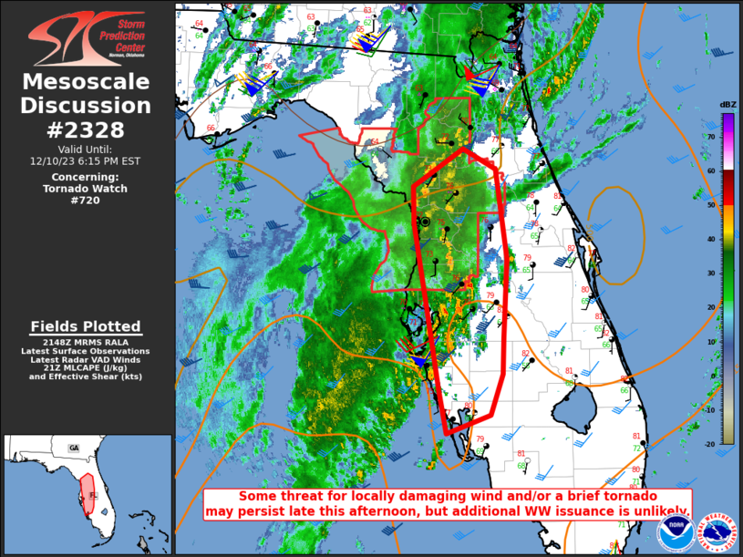
MD 2328 CONCERNING TORNADO WATCH 720... FOR PARTS OF NORTH INTO WEST-CENTRAL FL
Mesoscale Discussion 2328
NWS Storm Prediction Center Norman OK
0351 PM CST Sun Dec 10 2023

Areas affected...Parts of north into west-central FL

Concerning...Tornado Watch 720...

Valid 102151Z - 102315Z

The severe weather threat for Tornado Watch 720 continues.

SUMMARY...Some threat for locally damaging wind and/or a brief
tornado may persist through the remainder of the afternoon, but
additional watch issuance is considered unlikely.

DISCUSSION...An extensive band of convection has moved through north
into west-central Florida this afternoon. Storms have largely
remained subsevere thus far, with maximum wind gusts generally in
the 40-45 mph range. Deep-layer shear remains strong across the
region, and short-term guidance and the recent VWPs from KTBW
suggest there has been some increase in southwesterly low-level
flow. However, satellite and lightning trends indicate a general
decrease in storm intensity over the last hour. With stronger
large-scale ascent expected generally remain west and north of the
region, and limited potential for any additional destabilization,
substantial reintensification appears unlikely.

The strongest storms may pose a threat of isolated damaging wind and
perhaps a brief tornado through the remainder of the afternoon, but
with the threat expected to remain generally marginal and isolated,
additional watch issuance is unlikely after the 22 UTC expiration of
WW 720.

..Dean/Guyer.. 12/10/2023

...Please see www.spc.noaa.gov for graphic product...

ATTN...WFO...MLB...TBW...JAX...

LAT...LON   29228271 29618212 29408174 28488161 27688165 27308167
            26898180 26708232 27158240 27648249 28058256 28848270
            29228271
Read more -
MD 2329 CONCERNING TORNADO WATCH 721... FOR PORTIONS OF SOUTHEASTERN VIRGINIA AND EASTERN NORTH CAROLINA
Mesoscale Discussion 2329
NWS Storm Prediction Center Norman OK
0353 PM CST Sun Dec 10 2023

Areas affected...Portions of southeastern Virginia and eastern North
Carolina

Concerning...Tornado Watch 721...

Valid 102153Z - 102330Z

The severe weather threat for Tornado Watch 721 continues.

SUMMARY...A localized severe threat continues across portions of
Tornado Watch 721.

DISCUSSION...Latest observational data suggests two main corridors
that remain at least locally favorable for severe thunderstorms
across Tornado Watch 721. Off the Carolinas coast, a band of showers
and thunderstorms driven by low/midlevel warm advection are
streaming northward toward coastal NC, and some of these storms have
exhibited transient organization given ample low/deep-layer shear.
While instability over land is marginal, there is still some
potential that this activity could affect immediate coast areas and
pose a brief tornado risk and/or damaging-wind threat.

Farther north from north-central NC into southeast VA, the AKQ VWP
is sampling 50 kt near 1 km AGL, which is yielding strong low-level
shear with ample low-level hodograph curvature. Similarly, weak
instability has generally limited updraft strength, though subtle
backing of the low-level flow and substantial pressure falls may
provide some focus for thunderstorms into the evening. If any storms
can root at the surface, a tornado cannot be ruled out.

..Weinman.. 12/10/2023

...Please see www.spc.noaa.gov for graphic product...

ATTN...WFO...AKQ...MHX...RAH...ILM...

LAT...LON   34417734 34547787 34797820 35577832 37237781 37697742
            37737707 37617653 37047598 36137576 35397598 34897616
            34597655 34417734
Read more -
Severe Weather Statement issued December 10 at 4:31PM EST by NWS
-
WW 0720 Status Updates
STATUS REPORT ON WW 720

SEVERE WEATHER THREAT CONTINUES RIGHT OF A LINE FROM 50 WSW OCF
TO 30 SSE CTY TO 10 W GNV TO 25 E GNV.

WW 720 WILL BE ALLOWED TO EXPIRE AT 102200Z.

..SQUITIERI..12/10/23

ATTN...WFO...JAX...TBW...TAE...


STATUS REPORT FOR WT 720

SEVERE WEATHER THREAT CONTINUES FOR THE FOLLOWING AREAS

FLC001-017-053-083-101-119-102200-

FL
.    FLORIDA COUNTIES INCLUDED ARE

ALACHUA              CITRUS              HERNANDO
MARION               PASCO               SUMTER


GMZ850-102200-

CW

.    ADJACENT COASTAL WATERS INCLUDED ARE

COASTAL WATERS FROM TARPON SPRINGS TO SUWANNEE RIVER FL OUT 20 NM

THE WATCH STATUS MESSAGE IS FOR GUIDANCE PURPOSES ONLY.  PLEASE
REFER TO WATCH COUNTY NOTIFICATION STATEMENTS FOR OFFICIAL
INFORMATION ON COUNTIES...INDEPENDENT CITIES AND MARINE ZONES
CLEARED FROM SEVERE THUNDERSTORM AND TORNADO WATCHES.
Read more -
SPC Day 3-8 Fire Weather Outlook
Day 3-8 Fire Weather Outlook
NWS Storm Prediction Center Norman OK
0244 PM CST Sun Dec 10 2023

Valid 121200Z - 181200Z

Fire weather potential appears low through the extended period.
Long-range ensemble guidance continues to show a strong signal for
the development and maintenance of an unseasonably strong surface
high across the eastern two-thirds of the country for much of the
upcoming work week and into next weekend. This will favor cool
conditions and weak gradient winds with low probability for
widespread sustained winds over 20 mph. An upper disturbance
approaching the Southwest/southern High Plains may support areas of
breezy conditions around mid-week, but increasing rain chances
should limit fire weather concerns.

An offshore flow regime is likely late D3/Tuesday into D5/Thursday
along the southern CA coast as the aforementioned upper wave shifts
into the Southwest. However, long-range ensembles continue to show
only a modest signal for strong low to mid-level winds, which limits
confidence in the magnitude of the offshore flow regime. While
localized fire weather concerns are possible, confidence remains too
low to introduce highlights.

..Moore.. 12/10/2023

...Please see www.spc.noaa.gov/fire for graphic product...
Read more -
WW 0720 Status Updates
STATUS REPORT ON WW 720

SEVERE WEATHER THREAT CONTINUES RIGHT OF A LINE FROM 65 SSW CTY
TO 15 SSE CTY TO 15 WSW JAX.

..SQUITIERI..12/10/23

ATTN...WFO...JAX...TBW...TAE...


STATUS REPORT FOR WT 720

SEVERE WEATHER THREAT CONTINUES FOR THE FOLLOWING AREAS

FLC001-007-017-053-075-083-101-119-125-102140-

FL
.    FLORIDA COUNTIES INCLUDED ARE

ALACHUA              BRADFORD            CITRUS
HERNANDO             LEVY                MARION
PASCO                SUMTER              UNION


GMZ850-102140-

CW

.    ADJACENT COASTAL WATERS INCLUDED ARE

COASTAL WATERS FROM TARPON SPRINGS TO SUWANNEE RIVER FL OUT 20 NM

THE WATCH STATUS MESSAGE IS FOR GUIDANCE PURPOSES ONLY.  PLEASE
REFER TO WATCH COUNTY NOTIFICATION STATEMENTS FOR OFFICIAL
INFORMATION ON COUNTIES...INDEPENDENT CITIES AND MARINE ZONES
CLEARED FROM SEVERE THUNDERSTORM AND TORNADO WATCHES.
Read more


SPC - No watches are valid as of Mon Dec 11 02:09:02 UTC 2023
in Storm Prediction Center RSS Feed
Posted
View the full article